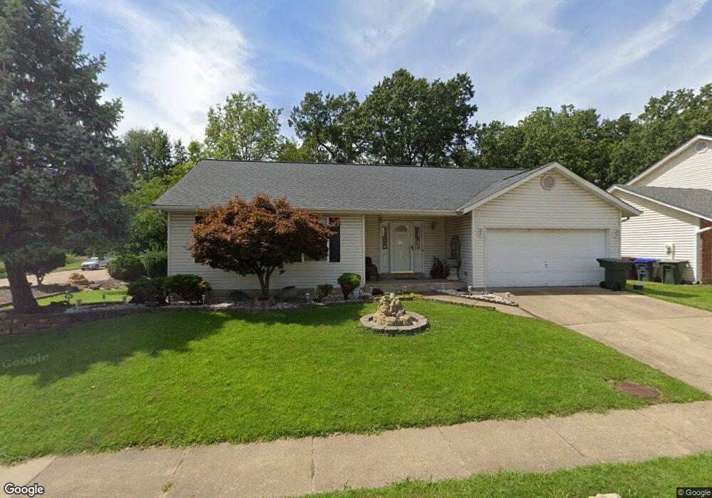
1169 Carrington Dr Saint Peters, MO 63376
Estimated Value: $328,446 - $352,000
3
Beds
2
Baths
1,421
Sq Ft
$238/Sq Ft
Est. Value
About This Home
This home is located at 1169 Carrington Dr, Saint Peters, MO 63376 and is currently estimated at $338,112, approximately $237 per square foot. 1169 Carrington Dr is a home located in St. Charles County with nearby schools including Lewis & Clark Elementary School, Dr. Bernard J. Dubray Middle School, and Fort Zumwalt East High School.
Ownership History
Date
Name
Owned For
Owner Type
Purchase Details
Closed on
May 11, 2007
Sold by
Finkelstein Jason and Finkelstein Natalie
Bought by
Finkelstein Jason and Clark Jack
Current Estimated Value
Purchase Details
Closed on
May 15, 2000
Sold by
Amlong James M and Haley Kathleen R
Bought by
Finkelstein Natalie and Finkelstein Jason
Purchase Details
Closed on
Mar 6, 1998
Sold by
Schmidt James H Laure A
Bought by
Amlong James M and Haley Kathleen R
Home Financials for this Owner
Home Financials are based on the most recent Mortgage that was taken out on this home.
Original Mortgage
$86,800
Interest Rate
7.08%
Create a Home Valuation Report for This Property
The Home Valuation Report is an in-depth analysis detailing your home's value as well as a comparison with similar homes in the area
Home Values in the Area
Average Home Value in this Area
Purchase History
| Date | Buyer | Sale Price | Title Company |
|---|---|---|---|
| Finkelstein Jason | -- | None Available | |
| Finkelstein Natalie | -- | -- | |
| Amlong James M | -- | -- |
Source: Public Records
Mortgage History
| Date | Status | Borrower | Loan Amount |
|---|---|---|---|
| Previous Owner | Amlong James M | $86,800 |
Source: Public Records
Tax History Compared to Growth
Tax History
| Year | Tax Paid | Tax Assessment Tax Assessment Total Assessment is a certain percentage of the fair market value that is determined by local assessors to be the total taxable value of land and additions on the property. | Land | Improvement |
|---|---|---|---|---|
| 2025 | $3,809 | $57,244 | -- | -- |
| 2023 | $3,806 | $53,415 | $0 | $0 |
| 2022 | $3,313 | $43,527 | $0 | $0 |
| 2021 | $3,308 | $43,527 | $0 | $0 |
| 2020 | $3,196 | $40,764 | $0 | $0 |
| 2019 | $3,188 | $40,764 | $0 | $0 |
| 2018 | $2,948 | $36,197 | $0 | $0 |
| 2017 | $2,935 | $36,197 | $0 | $0 |
| 2016 | $2,606 | $32,043 | $0 | $0 |
| 2015 | $2,440 | $32,043 | $0 | $0 |
| 2014 | $2,258 | $29,034 | $0 | $0 |
Source: Public Records
Map
Nearby Homes
- 1196 Colby Ct
- 537 Ryehill Dr
- 17 Forrel Tree Ct
- 5 Victoria Square
- 10 Eagles Glen Ct
- 22 Shadow Creek Dr
- 26 Jane Dr
- 1309 Whispering Ridge Ln
- 114 Long And Winding Rd
- 99 Long And Winding Rd
- 404 Kaliedoscope Ln
- 1 Marianne Dr
- 31 Carriage Way W
- 1126 Spencer Rd
- 19 Galaxy Dr
- 47 Dogwood Ln
- Brookmont Plan at Ryehill Manor
- Parker Plan at Ryehill Manor
- Whitehall Plan at Ryehill Manor
- Lansford Plan at Ryehill Manor
- 1167 Carrington Dr
- 2437 Carrington Dr
- 1168 Carrington Dr
- 1166 Carrington Dr
- 1163 Carrington Dr
- 1164 Carrington Dr
- 1162 Carrington Dr
- 8 Lisa Ct
- 1151 Colby Dr
- 1161 Carrington Dr
- 6 Lisa Ct
- 1150 Colby Dr
- 1 Carrington Ct
- 1159 Carrington Dr
- 1153 Colby Dr
- 3 Carrington Ct
- 5 Cavendish Square
- 4 Lisa Ct
- 10 Lisa Ct
- 3 Cavendish Square