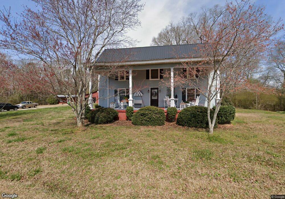
1169 Robertson Bridge Rd Statham, GA 30666
Estimated Value: $286,954 - $549,000
2
Beds
1
Bath
1,664
Sq Ft
$223/Sq Ft
Est. Value
About This Home
This home is located at 1169 Robertson Bridge Rd, Statham, GA 30666 and is currently estimated at $371,739, approximately $223 per square foot. 1169 Robertson Bridge Rd is a home located in Barrow County with nearby schools including Bethlehem Elementary School, Haymon-Morris Middle School, and Apalachee High School.
Ownership History
Date
Name
Owned For
Owner Type
Purchase Details
Closed on
Jan 11, 2002
Sold by
Mclocklin John R
Bought by
Mclocklin Patsy K
Current Estimated Value
Home Financials for this Owner
Home Financials are based on the most recent Mortgage that was taken out on this home.
Original Mortgage
$58,000
Interest Rate
6.85%
Mortgage Type
New Conventional
Purchase Details
Closed on
Jun 29, 2000
Bought by
Mclocklin James Est
Create a Home Valuation Report for This Property
The Home Valuation Report is an in-depth analysis detailing your home's value as well as a comparison with similar homes in the area
Home Values in the Area
Average Home Value in this Area
Purchase History
| Date | Buyer | Sale Price | Title Company |
|---|---|---|---|
| Mclocklin Patsy K | -- | -- | |
| Mclocklin James Est | -- | -- |
Source: Public Records
Mortgage History
| Date | Status | Borrower | Loan Amount |
|---|---|---|---|
| Closed | Mclocklin Patsy K | $58,000 |
Source: Public Records
Tax History Compared to Growth
Tax History
| Year | Tax Paid | Tax Assessment Tax Assessment Total Assessment is a certain percentage of the fair market value that is determined by local assessors to be the total taxable value of land and additions on the property. | Land | Improvement |
|---|---|---|---|---|
| 2024 | $621 | $78,626 | $50,038 | $28,588 |
| 2023 | $491 | $78,626 | $50,038 | $28,588 |
| 2022 | $601 | $68,472 | $50,038 | $18,434 |
| 2021 | $464 | $52,197 | $35,225 | $16,972 |
| 2020 | $1,833 | $60,171 | $44,660 | $15,511 |
| 2019 | $1,866 | $60,171 | $44,660 | $15,511 |
| 2018 | $1,844 | $60,171 | $44,660 | $15,511 |
| 2017 | $1,685 | $57,867 | $44,660 | $13,207 |
| 2016 | $1,763 | $57,867 | $44,660 | $13,207 |
| 2015 | $1,771 | $57,867 | $44,660 | $13,207 |
| 2014 | $1,118 | $35,091 | $21,884 | $13,207 |
| 2013 | -- | $34,475 | $21,883 | $12,592 |
Source: Public Records
Map
Nearby Homes
- 173 Annie Ln
- 151 Annie Ln
- 141 Annie Ln
- 127 Annie Ln
- 195 Annie Ln
- 115 Annie Ln
- 81 Purackal Ln
- 95 Purackal Ln
- 107 Purackal Ln
- 119 Purackal Ln
- 123 Purackal Ln
- 122 Purackal Ln
- 130 Purackal Ln
- 1006 Trichur Rd
- Packard Plan at Preserve at Dove Creek
- Galen Plan at Preserve at Dove Creek
- Cairn Plan at Preserve at Dove Creek
- 318 Abbott Rd
- Denton Plan at Preserve at Dove Creek
- Elle Plan at Preserve at Dove Creek
- 1181 Robertson Bridge Rd
- 3371 Kottayam Ct
- 3373 Kottayam Ct
- 3376 Kottayam Ct
- 3370 Kottayam Ct Unit 5C
- 3370 Kottayam Ct
- 1011 Alleppy Rd
- 1011 Alleppy Rd
- 1011 Alleppy Rd Unit 1011
- 1011 Alleppy Rd Unit 1001
- 3375 Kottayam Ct
- 3033 Kerala Pkwy
- 1009 Alleppy Rd
- 1586 Hog Mountain Rd
- 1010 Trichur Rd
- 1010 Trichur Rd Unit 1010
- 1010 Trichur Rd Unit 1001
- 3025 Kerala Pkwy
- 3027 Kerala Pkwy
- 3029 Kerala Pkwy