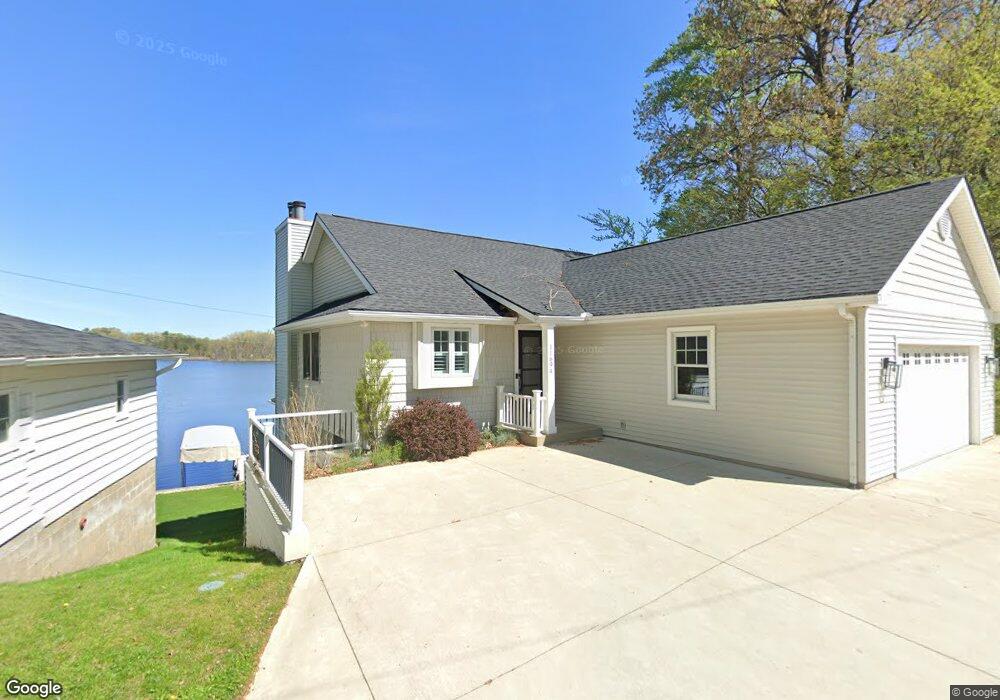
11694 Fords Point Dr Plainwell, MI 49080
Estimated Value: $673,000 - $741,000
--
Bed
--
Bath
1,240
Sq Ft
$573/Sq Ft
Est. Value
About This Home
This home is located at 11694 Fords Point Dr, Plainwell, MI 49080 and is currently estimated at $711,086, approximately $573 per square foot. 11694 Fords Point Dr is a home located in Barry County with nearby schools including Delton Kellogg Elementary School, Delton-Kellogg Middle School, and Delton-Kellogg High School.
Ownership History
Date
Name
Owned For
Owner Type
Purchase Details
Closed on
Jun 16, 2023
Sold by
Blaesing-Miller Erin Kathryn and Blaesing-Miller Lance Rob
Bought by
Mcquesten Joseph and Mcquesten Jaci
Current Estimated Value
Purchase Details
Closed on
Apr 28, 2023
Sold by
Kraft James A
Bought by
Blaesing-Miller Erin Kathryn
Purchase Details
Closed on
Jun 27, 2019
Sold by
Kraft James A and Graff Steven W
Bought by
Kraft James A and Graff Steven W
Home Financials for this Owner
Home Financials are based on the most recent Mortgage that was taken out on this home.
Original Mortgage
$130,000
Interest Rate
3.9%
Mortgage Type
New Conventional
Purchase Details
Closed on
Apr 1, 1994
Bought by
Kraft James
Create a Home Valuation Report for This Property
The Home Valuation Report is an in-depth analysis detailing your home's value as well as a comparison with similar homes in the area
Home Values in the Area
Average Home Value in this Area
Purchase History
| Date | Buyer | Sale Price | Title Company |
|---|---|---|---|
| Mcquesten Joseph | $650,000 | None Listed On Document | |
| Blaesing-Miller Erin Kathryn | $650,000 | Chicago Title | |
| Kraft James A | -- | None Available | |
| Kraft James | $24,900 | -- |
Source: Public Records
Mortgage History
| Date | Status | Borrower | Loan Amount |
|---|---|---|---|
| Previous Owner | Kraft James A | $130,000 |
Source: Public Records
Tax History Compared to Growth
Tax History
| Year | Tax Paid | Tax Assessment Tax Assessment Total Assessment is a certain percentage of the fair market value that is determined by local assessors to be the total taxable value of land and additions on the property. | Land | Improvement |
|---|---|---|---|---|
| 2025 | $3,071 | $274,500 | $0 | $0 |
| 2024 | $3,071 | $240,300 | $0 | $0 |
| 2023 | $2,888 | $189,000 | $0 | $0 |
| 2022 | $2,888 | $189,000 | $0 | $0 |
| 2021 | $2,841 | $177,200 | $0 | $0 |
| 2020 | $2,865 | $183,200 | $0 | $0 |
| 2019 | $2,845 | $171,200 | $0 | $0 |
| 2018 | $0 | $149,700 | $57,700 | $92,000 |
| 2017 | $0 | $149,700 | $0 | $0 |
| 2016 | -- | $128,800 | $0 | $0 |
| 2015 | -- | $120,500 | $0 | $0 |
| 2014 | -- | $120,500 | $0 | $0 |
Source: Public Records
Map
Nearby Homes
- 11625 Spring Point Dr
- 12651 Pine Lake Rd
- 12391 Sunset Dr
- 9700 Lindsey Rd
- 12387 Sunset Point Dr
- 12167 Southgate Dr
- 1217 Marsh Rd
- 8897 Cory Dr
- 11322 3 Mile Rd
- 8494 Marsh Rd
- VL Cory Dr
- 11463 Snowshoe Dr
- 0 Doster Rd Unit 22855337
- 24 Heron Ct
- 185 Hestia Dr Unit 7
- 667 Pierce Rd
- 7805 Cougar Dr
- 414 Midlakes Blvd
- 9308 W Guernsey Lake Rd
- 282 Doster Rd
- 11694 Ford Point Dr
- 11720 Fords Point Dr
- 11687 Ford Point Dr
- 11687 Fords Point Dr
- 11687 Fords Point Dr
- 11687 Fords Point Dr
- 11687 Fords Point Dr
- 11668 Fords Point Dr
- 11713 Ford Point Dr
- 11740 Fords Point Dr
- 11713 Fords Point Dr
- 11721 Fords Point Dr
- 11653 Ford Point Dr
- 11727 Fords Point Dr
- 11646 Fords Point Dr Unit 11646
- 11671 Ramseyer Dr
- 11650 Ramseyer Dr
- 11651 Fords Point Dr
- 11766 Fords Point Dr
- 11766 Fords Point Dr