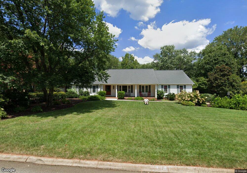
117 Coventry Rd Greenville, SC 29615
Eastside NeighborhoodEstimated Value: $576,493 - $658,000
4
Beds
3
Baths
2,800
Sq Ft
$223/Sq Ft
Est. Value
About This Home
This home is located at 117 Coventry Rd, Greenville, SC 29615 and is currently estimated at $625,373, approximately $223 per square foot. 117 Coventry Rd is a home located in Greenville County with nearby schools including Mitchell Road Elementary, Greenville Middle Academy, and Eastside High School.
Ownership History
Date
Name
Owned For
Owner Type
Purchase Details
Closed on
Dec 2, 2016
Sold by
Warren Jerel and Warren Sarah B
Bought by
Warren Jerel and Warren Sarah B
Current Estimated Value
Purchase Details
Closed on
May 13, 2009
Sold by
Youngblood James W and Youngblood Joy Dyer
Bought by
Warren Jerel and Warren Sarah B
Home Financials for this Owner
Home Financials are based on the most recent Mortgage that was taken out on this home.
Original Mortgage
$229,960
Outstanding Balance
$145,607
Interest Rate
4.89%
Mortgage Type
New Conventional
Estimated Equity
$479,766
Create a Home Valuation Report for This Property
The Home Valuation Report is an in-depth analysis detailing your home's value as well as a comparison with similar homes in the area
Home Values in the Area
Average Home Value in this Area
Purchase History
| Date | Buyer | Sale Price | Title Company |
|---|---|---|---|
| Warren Jerel | -- | None Available | |
| Warren Jerel | $287,450 | -- |
Source: Public Records
Mortgage History
| Date | Status | Borrower | Loan Amount |
|---|---|---|---|
| Open | Warren Jerel | $229,960 |
Source: Public Records
Tax History Compared to Growth
Tax History
| Year | Tax Paid | Tax Assessment Tax Assessment Total Assessment is a certain percentage of the fair market value that is determined by local assessors to be the total taxable value of land and additions on the property. | Land | Improvement |
|---|---|---|---|---|
| 2024 | $2,153 | $12,340 | $2,040 | $10,300 |
| 2023 | $2,153 | $12,340 | $2,040 | $10,300 |
| 2022 | $2,096 | $12,340 | $2,040 | $10,300 |
| 2021 | $2,061 | $12,340 | $2,040 | $10,300 |
| 2020 | $2,481 | $12,930 | $2,240 | $10,690 |
| 2019 | $2,454 | $12,930 | $2,240 | $10,690 |
| 2018 | $2,416 | $12,930 | $2,240 | $10,690 |
| 2017 | $2,388 | $12,930 | $2,240 | $10,690 |
| 2016 | $2,291 | $323,300 | $56,000 | $267,300 |
| 2015 | $2,277 | $323,300 | $56,000 | $267,300 |
| 2014 | $1,960 | $282,460 | $56,000 | $226,460 |
Source: Public Records
Map
Nearby Homes
- 2 Pilgrims Point Rd
- 604 Hudson Rd
- 102 Graystone Rd
- 4 Port Royal Dr
- 17 Seabury Dr
- 217 Redland Way Unit Homesite 09
- 724 Hudson Rd
- 205 Redland Way Unit Homesite 003
- Fairburn Elite Plan at Hudson Pointe
- Latimore Plan at Hudson Pointe
- Latimore with Basement Plan at Hudson Pointe
- Mossgrove with Basement Plan at Hudson Pointe
- Woodburn with Basement Plan at Hudson Pointe
- Mossgrove Plan at Hudson Pointe
- Woodburn Plan at Hudson Pointe
- 627 Pelham Rd
- 207 Redland Way
- 208 Redland Way
- 202 Redland Way
- 209 Redland Way Unit Homesite 05
- 113 Coventry Rd
- 121 Coventry Rd
- 415 Hudson Rd
- 508 Providence Square
- 128 Coventry Rd
- 109 Coventry Rd
- 512 Providence Square
- 124 Coventry Rd
- 504 Providence Square
- 132 Coventry Rd
- 125 Coventry Rd
- 120 Coventry Rd
- 500 Providence Square
- 136 Coventry Rd
- 105 Coventry Rd
- 116 Coventry Rd
- 101 Coventry Rd
- 121 Saint Augustine Dr
- 119 Saint Augustine Dr
- 140 Coventry Rd