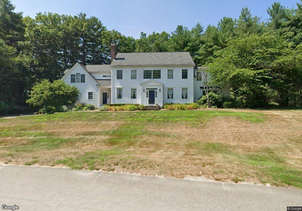
117 Davis Rd Carlisle, MA 01741
Estimated Value: $1,955,769 - $2,777,000
5
Beds
4
Baths
5,532
Sq Ft
$408/Sq Ft
Est. Value
About This Home
This home is located at 117 Davis Rd, Carlisle, MA 01741 and is currently estimated at $2,258,692, approximately $408 per square foot. 117 Davis Rd is a home located in Middlesex County with nearby schools including Carlisle School.
Ownership History
Date
Name
Owned For
Owner Type
Purchase Details
Closed on
Aug 19, 2014
Sold by
Soto Daniel E and Thakore Kosha S
Bought by
Kosha S Thakore Ret and Thakore Kosha S
Current Estimated Value
Purchase Details
Closed on
Sep 13, 2010
Sold by
Fosnight William J and Fosnight Terri S
Bought by
Soto Daniel E and Thakore Kosha S
Home Financials for this Owner
Home Financials are based on the most recent Mortgage that was taken out on this home.
Original Mortgage
$836,000
Interest Rate
4.55%
Mortgage Type
Purchase Money Mortgage
Purchase Details
Closed on
Apr 16, 2002
Sold by
Gantz Jordan M and Gantz Vicki R
Bought by
Fosnight William J and Fosnight Terri S
Home Financials for this Owner
Home Financials are based on the most recent Mortgage that was taken out on this home.
Original Mortgage
$650,000
Interest Rate
6.84%
Mortgage Type
Purchase Money Mortgage
Create a Home Valuation Report for This Property
The Home Valuation Report is an in-depth analysis detailing your home's value as well as a comparison with similar homes in the area
Home Values in the Area
Average Home Value in this Area
Purchase History
| Date | Buyer | Sale Price | Title Company |
|---|---|---|---|
| Kosha S Thakore Ret | -- | -- | |
| Soto Daniel E | $1,045,000 | -- | |
| Fosnight William J | $1,080,000 | -- |
Source: Public Records
Mortgage History
| Date | Status | Borrower | Loan Amount |
|---|---|---|---|
| Previous Owner | Soto Daniel E | $836,000 | |
| Previous Owner | Fosnight William J | $650,000 | |
| Previous Owner | Fosnight William J | $75,000 |
Source: Public Records
Tax History Compared to Growth
Tax History
| Year | Tax Paid | Tax Assessment Tax Assessment Total Assessment is a certain percentage of the fair market value that is determined by local assessors to be the total taxable value of land and additions on the property. | Land | Improvement |
|---|---|---|---|---|
| 2025 | $24,544 | $1,862,200 | $588,400 | $1,273,800 |
| 2024 | $23,995 | $1,800,100 | $544,800 | $1,255,300 |
| 2023 | $24,339 | $1,720,100 | $522,900 | $1,197,200 |
| 2022 | $21,203 | $1,285,000 | $435,700 | $849,300 |
| 2021 | $20,920 | $1,285,000 | $435,700 | $849,300 |
| 2020 | $22,441 | $1,222,300 | $370,400 | $851,900 |
| 2019 | $21,943 | $1,199,700 | $370,400 | $829,300 |
| 2018 | $21,799 | $1,199,700 | $370,400 | $829,300 |
| 2017 | $20,378 | $1,156,500 | $370,400 | $786,100 |
| 2016 | $19,751 | $1,148,300 | $370,400 | $777,900 |
| 2015 | $18,998 | $999,900 | $352,900 | $647,000 |
| 2014 | $18,638 | $999,900 | $352,900 | $647,000 |
Source: Public Records
Map
Nearby Homes
- 125 Maple St
- 282 Brook St
- 11 Kay's Walk
- 373 E Riding Dr
- 383 E Riding Dr
- 232 Baldwin Rd
- 6 Edgehill Rd
- 63 Outlook Rd
- 43 Outlook Rd
- 4 Dove Ln
- 225 Lowell St
- 7 Alder Way Unit 159
- 5 Chestnut Ln Unit 120
- 3 Kay's Walk
- 15 Kay's Walk
- 1 Kay's Walk Unit 1
- 1 Kay's Walk
- 13 Kay's Walk
- 15 Kay's Walk Unit 4
- 3 Kay's Walk Unit 3