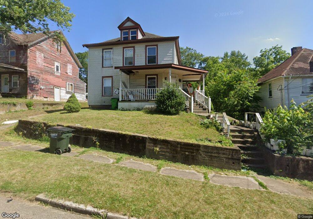
117 Dwight Ave SE Massillon, OH 44646
Downtown Massillon NeighborhoodEstimated Value: $114,000 - $133,000
3
Beds
2
Baths
1,642
Sq Ft
$73/Sq Ft
Est. Value
About This Home
This home is located at 117 Dwight Ave SE, Massillon, OH 44646 and is currently estimated at $119,730, approximately $72 per square foot. 117 Dwight Ave SE is a home located in Stark County with nearby schools including Massillon Intermediate School, Massillon Junior High School, and Washington High School.
Ownership History
Date
Name
Owned For
Owner Type
Purchase Details
Closed on
Jun 7, 2021
Sold by
Gracak Milan and Zumbar Alexander A
Bought by
Hartman Chad M
Current Estimated Value
Purchase Details
Closed on
Aug 31, 2005
Sold by
Gracak Milan and Gracak Terri L
Bought by
Gracak Milan and Gracak Terri L
Purchase Details
Closed on
Dec 1, 2000
Sold by
Mcmullen Zorka
Bought by
Gracak Milan
Create a Home Valuation Report for This Property
The Home Valuation Report is an in-depth analysis detailing your home's value as well as a comparison with similar homes in the area
Home Values in the Area
Average Home Value in this Area
Purchase History
| Date | Buyer | Sale Price | Title Company |
|---|---|---|---|
| Hartman Chad M | $15,000 | None Available | |
| Gracak Milan | -- | Patriot Land Title Agency Lt | |
| Gracak Milan | $48,600 | -- |
Source: Public Records
Tax History Compared to Growth
Tax History
| Year | Tax Paid | Tax Assessment Tax Assessment Total Assessment is a certain percentage of the fair market value that is determined by local assessors to be the total taxable value of land and additions on the property. | Land | Improvement |
|---|---|---|---|---|
| 2025 | -- | $30,490 | $5,810 | $24,680 |
| 2024 | -- | $30,490 | $5,810 | $24,680 |
| 2023 | $888 | $16,880 | $3,960 | $12,920 |
| 2022 | $1,236 | $16,880 | $3,960 | $12,920 |
| 2021 | $536 | $16,880 | $3,960 | $12,920 |
| 2020 | $1,100 | $13,720 | $3,220 | $10,500 |
| 2019 | $949 | $13,720 | $3,220 | $10,500 |
| 2018 | $604 | $13,720 | $3,220 | $10,500 |
| 2017 | $5,423 | $10,580 | $1,790 | $8,790 |
| 2016 | $4,735 | $10,230 | $1,440 | $8,790 |
| 2015 | $440 | $10,230 | $1,440 | $8,790 |
| 2014 | $665 | $10,500 | $1,470 | $9,030 |
| 2013 | $334 | $10,500 | $1,470 | $9,030 |
Source: Public Records
Map
Nearby Homes
- 233 Edwin Ave SE
- 17 Maple Ave SE
- 804 Erie St S
- 1225 Erie St S
- 652 Young St SE
- 1319 Walnut Rd SE
- 1274 13th St SE
- 0 Pearl SE Unit 5155028
- 1117 Cleveland St SW
- 505 Neale Ave SW
- 202 Rose Ave SE
- 20 Forest Ave SE
- 22 Forest Ave SE
- 1738 Erie St S
- 25 Forest Ave SE
- 21 Forest Ave SE
- 532 4th St SW
- 509 Tremont Ave SE
- 824 Oak Ave SE
- 512 6th St SW
- 111 Dwight Ave SE
- 123 Dwight Ave SE
- 105 Dwight Ave SE
- 129 Dwight Ave SE
- 1017 2nd St SE
- 114 Arch Ave SE
- 133 Dwight Ave SE
- 1023 2nd St SE
- 112 Dwight Ave SE
- 122 Dwight Ave SE
- 108 Dwight Ave SE
- 35 Dwight Ave SE
- 104 Arch Ave SE
- 126 Dwight Ave SE
- 104 Dwight Ave SE
- 33 Dwight Ave SE
- 130 Dwight Ave SE
- 36 Arch Ave SE
- 34 Dwight Ave SE
- 117 Edwin Ave SE