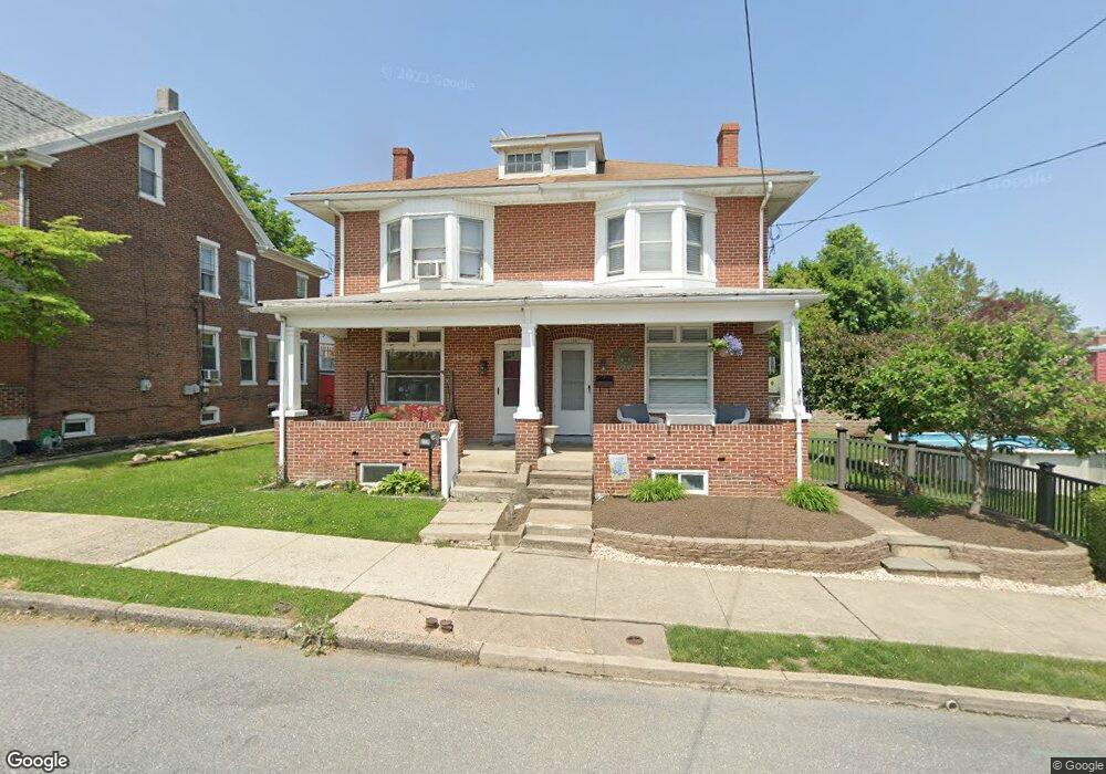
117 E Race St Pottstown, PA 19464
Estimated Value: $219,000 - $274,000
3
Beds
1
Bath
1,216
Sq Ft
$202/Sq Ft
Est. Value
About This Home
This home is located at 117 E Race St, Pottstown, PA 19464 and is currently estimated at $246,003, approximately $202 per square foot. 117 E Race St is a home located in Montgomery County with nearby schools including Lower Pottsgrove Elementary School, Pottsgrove Middle School, and Pottsgrove Senior High School.
Ownership History
Date
Name
Owned For
Owner Type
Purchase Details
Closed on
Mar 10, 2010
Sold by
Wooten Tony and Wooten Laurie
Bought by
Wooten Laurie
Current Estimated Value
Purchase Details
Closed on
Apr 28, 2004
Sold by
Miller Adrien S and Miller Tracy L
Bought by
Wooten Tony and Wooten Laurie
Purchase Details
Closed on
Apr 22, 1999
Sold by
Miller Adrien S and Miller Tracy L
Bought by
Miller Adrien S and Miller Tracy L
Purchase Details
Closed on
Apr 30, 1996
Sold by
Whitney Shirley A
Bought by
Miller Adrien S and Shantz Tracy L
Create a Home Valuation Report for This Property
The Home Valuation Report is an in-depth analysis detailing your home's value as well as a comparison with similar homes in the area
Home Values in the Area
Average Home Value in this Area
Purchase History
| Date | Buyer | Sale Price | Title Company |
|---|---|---|---|
| Wooten Laurie | -- | None Available | |
| Wooten Tony | $100,000 | -- | |
| Miller Adrien S | -- | -- | |
| Miller Adrien S | $79,500 | -- |
Source: Public Records
Tax History
| Year | Tax Paid | Tax Assessment Tax Assessment Total Assessment is a certain percentage of the fair market value that is determined by local assessors to be the total taxable value of land and additions on the property. | Land | Improvement |
|---|---|---|---|---|
| 2025 | $3,614 | $75,240 | $33,270 | $41,970 |
| 2024 | $3,614 | $75,240 | $33,270 | $41,970 |
| 2023 | $3,500 | $75,240 | $33,270 | $41,970 |
| 2022 | $3,446 | $75,240 | $33,270 | $41,970 |
| 2021 | $3,395 | $75,240 | $33,270 | $41,970 |
| 2020 | $3,345 | $75,240 | $33,270 | $41,970 |
| 2019 | $3,327 | $75,240 | $33,270 | $41,970 |
| 2018 | $3,326 | $75,240 | $33,270 | $41,970 |
| 2017 | $3,315 | $75,240 | $33,270 | $41,970 |
| 2016 | $3,286 | $75,240 | $33,270 | $41,970 |
| 2015 | $3,172 | $75,240 | $33,270 | $41,970 |
| 2014 | $3,172 | $75,240 | $33,270 | $41,970 |
Source: Public Records
Map
Nearby Homes
- 203 Lemon St
- 20 E Howard St
- 601 W High St
- 1001 W High St
- 511 E Vine St Unit 73
- 536 & 538 W Vine St
- 703 Holly Dr
- 801 Glasgow St
- 14 Kristen Cir
- 225 Potts Dr
- 50 Middlemarch Rd
- 25 Middlemarch Rd
- 77 Random Rd
- 66 Random Rd
- 145 Random Rd
- 313 W Walnut St
- 86 Westin Rd
- 241 W King St
- 0 Squirrel Hollow Rd
- 2 Walnut St
Your Personal Tour Guide
Ask me questions while you tour the home.