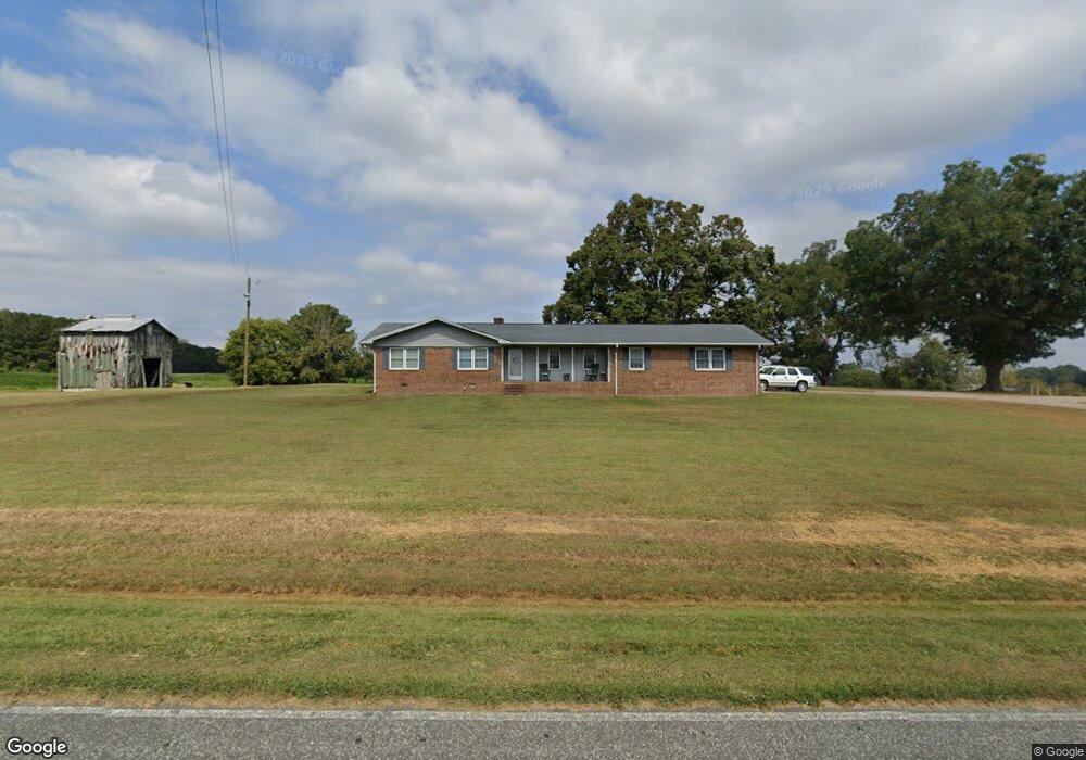
117 Egypt Church Rd Louisburg, NC 27549
Estimated Value: $357,000 - $2,589,434
4
Beds
2
Baths
1,904
Sq Ft
$774/Sq Ft
Est. Value
About This Home
This home is located at 117 Egypt Church Rd, Louisburg, NC 27549 and is currently estimated at $1,473,217, approximately $773 per square foot. 117 Egypt Church Rd is a home located in Franklin County with nearby schools including Louisburg Elementary School, Terrell Lane Middle School, and Louisburg High School.
Ownership History
Date
Name
Owned For
Owner Type
Purchase Details
Closed on
Apr 15, 2024
Sold by
Holmes Elmar Newton
Bought by
Elmar Newton Holmes Revocable Trust and Holmes
Current Estimated Value
Purchase Details
Closed on
Oct 29, 2019
Sold by
Newton C H C and Newton Sara C
Bought by
Averett Timothy J
Purchase Details
Closed on
Jul 10, 2019
Sold by
Batton David Carlton and Batton Julie A
Bought by
Averette Timothy J
Create a Home Valuation Report for This Property
The Home Valuation Report is an in-depth analysis detailing your home's value as well as a comparison with similar homes in the area
Home Values in the Area
Average Home Value in this Area
Purchase History
| Date | Buyer | Sale Price | Title Company |
|---|---|---|---|
| Elmar Newton Holmes Revocable Trust | -- | None Listed On Document | |
| Averett Timothy J | $1,500 | None Available | |
| Averette Timothy J | -- | None Available |
Source: Public Records
Tax History Compared to Growth
Tax History
| Year | Tax Paid | Tax Assessment Tax Assessment Total Assessment is a certain percentage of the fair market value that is determined by local assessors to be the total taxable value of land and additions on the property. | Land | Improvement |
|---|---|---|---|---|
| 2025 | $2,192 | $2,172,790 | $2,023,030 | $149,760 |
| 2024 | $2,192 | $2,172,790 | $2,023,030 | $149,760 |
| 2023 | $2,255 | $834,630 | $716,160 | $118,470 |
| 2022 | $2,245 | $834,630 | $716,160 | $118,470 |
| 2021 | $2,269 | $834,630 | $716,160 | $118,470 |
| 2020 | $2,266 | $835,560 | $717,090 | $118,470 |
| 2019 | $2,243 | $835,560 | $717,090 | $118,470 |
| 2018 | $2,927 | $834,350 | $715,880 | $118,470 |
| 2017 | $2,904 | $715,790 | $623,590 | $92,200 |
| 2016 | $3,005 | $715,790 | $623,590 | $92,200 |
| 2015 | $2,990 | $715,790 | $623,590 | $92,200 |
| 2014 | $2,814 | $715,790 | $623,590 | $92,200 |
Source: Public Records
Map
Nearby Homes
- 114 Fox Park Rd
- 631 N Carolina 39
- 560 S N C 39 Hwy
- 1213 U S 401
- Glimmer Plan at Green Hill
- Radiance Plan at Green Hill
- Solstice Plan at Green Hill
- Beacon Plan at Green Hill
- Luna Plan at Green Hill
- Falcon Plan at Green Hill
- Hubble Plan at Green Hill
- 23 Rolling Banks Dr
- 0 Us 401 Hwy S
- 3004 Us 401 Hwy S
- 65 Hillside Village Dr
- 25 Hillside Village Dr
- 928 N Main St
- 403 Ridley St
- 405 Ridley St
- 202 Cooper St
- 117 Egypt Church Rd
- 119 Egypt Church Rd
- 193 Egypt Church Rd
- 1573 Nc 39 Hwy S
- 1573 Nc 39 Hwy S
- 197 Egypt Church Rd
- 5 Egypt Church Rd
- 194 Egypt Church Rd
- 1596 Nc 39 Hwy S
- 251 Egypt Church Rd
- 1720 Nc 39 Hwy S
- 1720 N Carolina 39
- 1490 Nc 39 Hwy S
- 1490 N Carolina 39
- 320 Egypt Church Rd
- 1769 Nc 39 Hwy S
- 1769 Nc 39 Hwy S
- 1769 Nc 39 Hwy S
- 323 Egypt Church Rd
- 1472 Nc 39 Hwy S