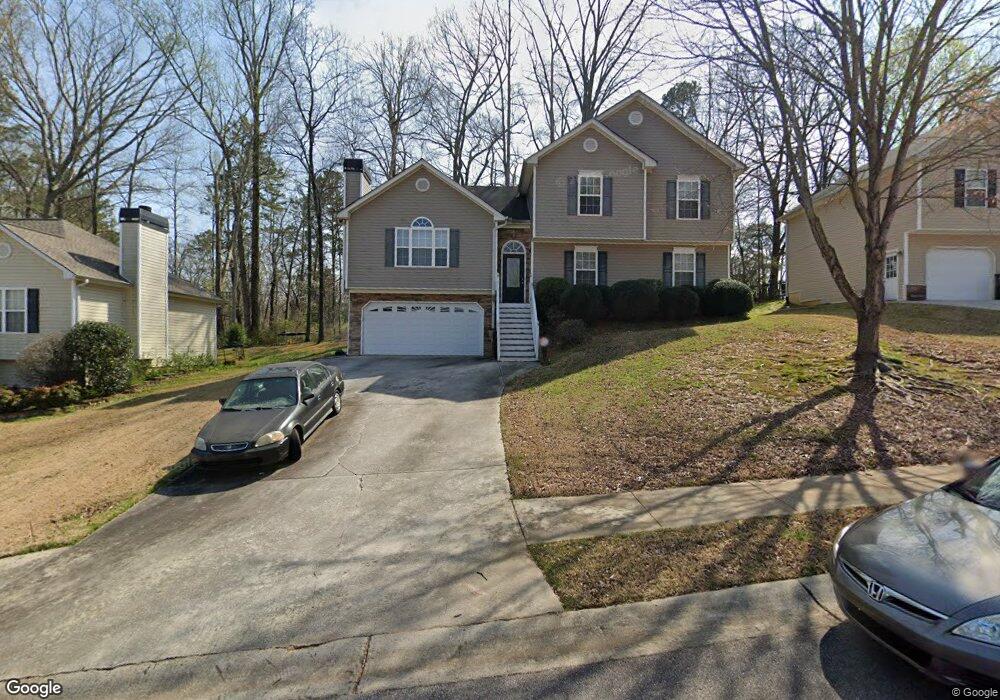
117 Jake Taylor Dr Acworth, GA 30102
Oak Grove NeighborhoodEstimated Value: $352,000 - $396,432
4
Beds
3
Baths
2,084
Sq Ft
$180/Sq Ft
Est. Value
About This Home
This home is located at 117 Jake Taylor Dr, Acworth, GA 30102 and is currently estimated at $374,216, approximately $179 per square foot. 117 Jake Taylor Dr is a home located in Cherokee County with nearby schools including Oak Grove Elementary School, E. T. Booth Middle School, and Etowah High School.
Ownership History
Date
Name
Owned For
Owner Type
Purchase Details
Closed on
Sep 30, 2004
Sold by
Riverstone Homes Inc
Bought by
Byrd Detrianne W
Current Estimated Value
Home Financials for this Owner
Home Financials are based on the most recent Mortgage that was taken out on this home.
Original Mortgage
$176,100
Outstanding Balance
$85,640
Interest Rate
5.71%
Mortgage Type
VA
Estimated Equity
$288,576
Create a Home Valuation Report for This Property
The Home Valuation Report is an in-depth analysis detailing your home's value as well as a comparison with similar homes in the area
Home Values in the Area
Average Home Value in this Area
Purchase History
| Date | Buyer | Sale Price | Title Company |
|---|---|---|---|
| Byrd Detrianne W | $178,900 | -- |
Source: Public Records
Mortgage History
| Date | Status | Borrower | Loan Amount |
|---|---|---|---|
| Open | Byrd Detrianne W | $176,100 |
Source: Public Records
Tax History Compared to Growth
Tax History
| Year | Tax Paid | Tax Assessment Tax Assessment Total Assessment is a certain percentage of the fair market value that is determined by local assessors to be the total taxable value of land and additions on the property. | Land | Improvement |
|---|---|---|---|---|
| 2025 | $3,468 | $150,040 | $28,000 | $122,040 |
| 2024 | $3,461 | $150,840 | $28,000 | $122,840 |
| 2023 | $3,183 | $158,280 | $28,000 | $130,280 |
| 2022 | $2,792 | $117,480 | $20,800 | $96,680 |
| 2021 | $2,644 | $101,080 | $20,800 | $80,280 |
| 2020 | $2,423 | $91,440 | $16,000 | $75,440 |
| 2019 | $2,275 | $85,080 | $16,000 | $69,080 |
| 2018 | $2,061 | $75,400 | $12,800 | $62,600 |
| 2017 | $1,818 | $172,600 | $12,800 | $56,240 |
| 2016 | $1,818 | $161,900 | $12,800 | $51,960 |
| 2015 | $1,696 | $150,000 | $12,000 | $48,000 |
| 2014 | $1,694 | $149,500 | $11,200 | $48,600 |
Source: Public Records
Map
Nearby Homes
- 302 Seth Way
- 6312 Woodstock Rd
- 6390 Woodstock Rd
- 6375 Caladium Dr
- 206 Cameron Ct
- 307 Queensbury Walk
- 313 Maltibie Dr
- 145 Winner St
- 626 Spanish Oak Dr
- 271 Oak Grove Way
- 577 Oakside Place
- 400 Sable Trace Cove
- 148 Sable Trace Trail
- 402 Royal Oak Dr
- 423 Royal Oak Dr
- 222 Gallant Fox Way
- 6147 Little Ridge Rd
- 6155 Little Ridge Rd
- 119 Jake Taylor Dr
- 115 Jake Taylor Dr
- 0 Jake Taylor Dr Unit 8179665
- 0 Jake Taylor Dr Unit 7571035
- 0 Jake Taylor Dr Unit 8066601
- 0 Jake Taylor Dr Unit 7311165
- 0 Jake Taylor Dr Unit 7212872
- 0 Jake Taylor Dr Unit 8850649
- 0 Jake Taylor Dr Unit 8867567
- 0 Jake Taylor Dr Unit 8920229
- 0 Jake Taylor Dr Unit 3251964
- 0 Jake Taylor Dr
- 201 Julia Lynn Ln
- 121 Jake Taylor Dr
- 113 Jake Taylor Dr
- 116 Jake Taylor Dr
- 123 Jake Taylor Dr
- 111 Jake Taylor Dr
- 118 Jake Taylor Dr
- 200 Julia Lynn Ln