
Seller's Agent in 2025
Brian Allen
Inc Realty, PLLC
(580) 217-7435
159 Total Sales
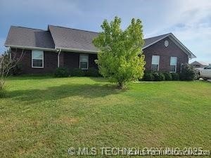
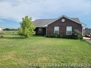
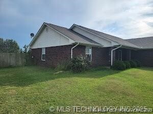
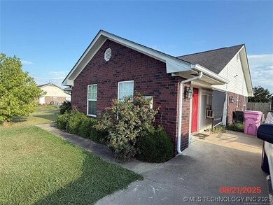
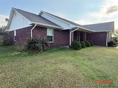
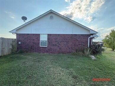
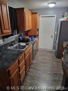
Investor Special! This 3-bedroom, 2-bath, single-story home offers 1,977 sq. ft. (County Assessor) of living space and sits on an oversized 0.53-acre lot (County Assessor) in the desirable Cedar Ridge Estates subdivision. Built in 2011 with a traditional brick exterior, slab foundation, and gable roof, this property has solid bones and endless potential. With a little work, you could save thousands while creating a wonderful family home or rental investment. Inside, the layout features a spacious living area, three generous bedrooms, and two full bathrooms. The home is equipped with a heat pump for efficient heating and cooling, along with an open front porch that adds welcoming curb appeal. While cosmetic updates and repairs are needed, this fixer-upper is priced for a quick sale, a rare opportunity in today’s market. Seller will review any and all offers, making this an investor’s dream. Location is everything, and this property offers convenience as well as potential. Situated just 10 minutes from downtown Durant, you’ll have quick access to major employers such as the Choctaw Nation Headquarters, Choctaw Casino & Resort, AllianceHealth Durant, and Southeastern Oklahoma State University. For commuters, Sherman/Denison, TX, is only 25 minutes south via Hwy 69/75, with major employers like Texas Instruments, Kaiser Aluminum, and Tyson Foods. Local amenities include nearby schools within the Durant ISD, shopping and dining in Durant and Calera, and easy access to outdoor recreation. Lake Texoma is just 15 minutes away, offering world-class fishing, boating, and camping. Residents also enjoy proximity to Choctaw Casino’s restaurants and entertainment venues, as well as Durant’s growing retail centers. This property is priced below market to allow for updates and repairs, allowing you to build instant equity. Whether you’re an investor looking for your next project or a buyer ready to put in sweat equity, 117 Michael Ave is a fantastic opportunity. Don’t miss it!
| Date | Type | Sale Price | Title Company |
|---|---|---|---|
| Warranty Deed | $186,500 | Fidelity National Title | |
| Quit Claim Deed | -- | None Listed On Document | |
| Warranty Deed | $10,000 | None Available |
| Date | Status | Loan Amount | Loan Type |
|---|---|---|---|
| Open | $165,000 | Construction | |
| Previous Owner | $95,000 | Purchase Money Mortgage |
| Date | Event | Price | List to Sale | Price per Sq Ft |
|---|---|---|---|---|
| 12/10/2025 12/10/25 | Sold | $186,500 | -4.3% | $94 / Sq Ft |
| 10/13/2025 10/13/25 | Pending | -- | -- | -- |
| 10/03/2025 10/03/25 | For Sale | $194,900 | -- | $99 / Sq Ft |
| Year | Tax Paid | Tax Assessment Tax Assessment Total Assessment is a certain percentage of the fair market value that is determined by local assessors to be the total taxable value of land and additions on the property. | Land | Improvement |
|---|---|---|---|---|
| 2025 | $1,646 | $18,433 | $990 | $17,443 |
| 2024 | $1,646 | $17,896 | $990 | $16,906 |
| 2023 | $1,646 | $17,375 | $990 | $16,385 |
| 2022 | $1,490 | $16,869 | $990 | $15,879 |
| 2021 | $1,526 | $16,869 | $990 | $15,879 |
| 2020 | $1,524 | $16,869 | $990 | $15,879 |
| 2019 | $1,478 | $17,306 | $990 | $16,316 |
| 2018 | $1,125 | $13,523 | $990 | $12,533 |
| 2017 | $1,083 | $13,128 | $990 | $12,138 |
| 2016 | $1,104 | $13,255 | $990 | $12,265 |
| 2015 | $1,099 | $13,255 | $990 | $12,265 |
| 2014 | $1,098 | $13,255 | $1,100 | $12,155 |
Seller's Agent in 2025
Brian Allen
Inc Realty, PLLC
(580) 217-7435
159 Total Sales
Source: MLS Technology
MLS Number: 2542108
APN: 0154-00-003-004-0-000-00
Disclaimer: Certain information contained herein is derived from information provided by parties other than Homes.com. All information provided is deemed reliable, but is not guaranteed to be accurate and should be independently verified.
![]() IDX information is provided exclusively for personal, non-commercial use, and may not be used for any purpose other than to identify prospective properties consumers may be interested in purchasing.
IDX information is provided exclusively for personal, non-commercial use, and may not be used for any purpose other than to identify prospective properties consumers may be interested in purchasing.
Information is deemed reliable but not guaranteed.
Ask me questions while you tour the home.