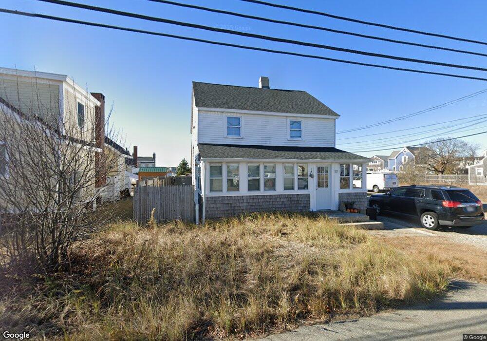
117 Northern Blvd Newbury, MA 01951
Estimated Value: $783,000 - $931,000
1
Bed
2
Baths
1,152
Sq Ft
$723/Sq Ft
Est. Value
About This Home
This home is located at 117 Northern Blvd, Newbury, MA 01951 and is currently estimated at $833,119, approximately $723 per square foot. 117 Northern Blvd is a home located in Essex County with nearby schools including Triton Regional High School and Immaculate Conception School.
Ownership History
Date
Name
Owned For
Owner Type
Purchase Details
Closed on
Aug 9, 2011
Sold by
Martha Keville Nt and Keville
Bought by
Gagne Joel and Gagne Patina
Current Estimated Value
Home Financials for this Owner
Home Financials are based on the most recent Mortgage that was taken out on this home.
Original Mortgage
$221,600
Outstanding Balance
$152,454
Interest Rate
4.51%
Mortgage Type
Purchase Money Mortgage
Estimated Equity
$680,665
Create a Home Valuation Report for This Property
The Home Valuation Report is an in-depth analysis detailing your home's value as well as a comparison with similar homes in the area
Home Values in the Area
Average Home Value in this Area
Purchase History
| Date | Buyer | Sale Price | Title Company |
|---|---|---|---|
| Gagne Joel | $277,000 | -- | |
| Gagne Joel | $277,000 | -- |
Source: Public Records
Mortgage History
| Date | Status | Borrower | Loan Amount |
|---|---|---|---|
| Open | Gagne Joel | $30,000 | |
| Open | Gagne Joel | $221,600 | |
| Closed | Gagne Joel | $221,600 |
Source: Public Records
Tax History Compared to Growth
Tax History
| Year | Tax Paid | Tax Assessment Tax Assessment Total Assessment is a certain percentage of the fair market value that is determined by local assessors to be the total taxable value of land and additions on the property. | Land | Improvement |
|---|---|---|---|---|
| 2025 | $6,176 | $829,000 | $596,300 | $232,700 |
| 2024 | $5,924 | $771,400 | $556,500 | $214,900 |
| 2023 | $4,833 | $557,400 | $362,700 | $194,700 |
| 2022 | $4,631 | $475,900 | $308,100 | $167,800 |
| 2021 | $4,472 | $419,500 | $258,400 | $161,100 |
| 2020 | $4,114 | $374,300 | $218,600 | $155,700 |
| 2019 | $4,046 | $374,300 | $218,600 | $155,700 |
| 2018 | $3,904 | $358,200 | $218,600 | $139,600 |
| 2017 | $3,743 | $352,800 | $218,600 | $134,200 |
| 2016 | $3,569 | $313,100 | $218,600 | $94,500 |
| 2015 | $3,379 | $293,300 | $198,800 | $94,500 |
| 2014 | $3,320 | $293,300 | $198,800 | $94,500 |
Source: Public Records
Map
Nearby Homes
- 4 54th St
- 12 53rd St
- 44 Old Point Rd
- 5 Helena St
- 5 Northern Blvd
- 2 Plum Island Blvd
- 11 Harbor St
- 12 Barker St
- 11 Sunset Dr
- 2 Sunset Dr
- 28 & 30 Plum Island Turnpike
- 65 Plum Island Turnpike
- 10 Meadowview Ln Unit B
- 141 Atlantic Ave
- 116 Railroad Ave
- 114 Railroad Ave
- 52 Brissette Ave
- 103 Railroad Ave
- 101 Cable Ave
- 33 Union St
- 3 38th St
- 2 40th St
- 3 42nd St
- 4 40th St
- 6 42nd St
- 123 Northern Blvd
- 122 Northern Blvd
- 120 Northern Blvd
- 0 39th St
- 8 40th St
- 111 Northern Blvd
- 111 Northern Blvd Unit 1
- 2 Basin Front Dr
- 4 Basin Front Dr
- 124 Northern Blvd Unit 124
- 124 Northern Blvd Unit WINTER
- 125 Northern Blvd
- 3 44th St
- 3 37th St
- 3 37th St Unit Winter