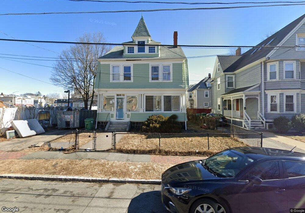
117 Otis St Medford, MA 02155
Glenwood NeighborhoodEstimated Value: $1,083,000 - $1,347,000
6
Beds
3
Baths
3,302
Sq Ft
$376/Sq Ft
Est. Value
About This Home
This home is located at 117 Otis St, Medford, MA 02155 and is currently estimated at $1,242,990, approximately $376 per square foot. 117 Otis St is a home located in Middlesex County with nearby schools including Medford High School, Mystic Valley Regional Charter School, and St. Joseph School.
Ownership History
Date
Name
Owned For
Owner Type
Purchase Details
Closed on
Jan 7, 1988
Sold by
Miraglia Robert V
Bought by
Richardson Thomas C
Current Estimated Value
Home Financials for this Owner
Home Financials are based on the most recent Mortgage that was taken out on this home.
Original Mortgage
$100,000
Interest Rate
10.52%
Mortgage Type
Purchase Money Mortgage
Create a Home Valuation Report for This Property
The Home Valuation Report is an in-depth analysis detailing your home's value as well as a comparison with similar homes in the area
Home Values in the Area
Average Home Value in this Area
Purchase History
| Date | Buyer | Sale Price | Title Company |
|---|---|---|---|
| Richardson Thomas C | $200,000 | -- |
Source: Public Records
Mortgage History
| Date | Status | Borrower | Loan Amount |
|---|---|---|---|
| Closed | Richardson Thomas C | $118,000 | |
| Closed | Richardson Thomas C | $19,607 | |
| Closed | Richardson Thomas C | $100,000 |
Source: Public Records
Tax History Compared to Growth
Tax History
| Year | Tax Paid | Tax Assessment Tax Assessment Total Assessment is a certain percentage of the fair market value that is determined by local assessors to be the total taxable value of land and additions on the property. | Land | Improvement |
|---|---|---|---|---|
| 2025 | $10,131 | $1,151,300 | $345,000 | $806,300 |
| 2024 | $9,268 | $1,087,800 | $328,500 | $759,300 |
| 2023 | $6,866 | $793,700 | $307,000 | $486,700 |
| 2022 | $6,371 | $707,100 | $279,100 | $428,000 |
| 2021 | $6,333 | $673,000 | $265,800 | $407,200 |
| 2020 | $6,247 | $680,500 | $265,800 | $414,700 |
| 2019 | $6,028 | $627,900 | $241,600 | $386,300 |
| 2018 | $5,623 | $549,100 | $219,600 | $329,500 |
| 2017 | $5,455 | $516,600 | $205,300 | $311,300 |
| 2016 | $5,247 | $468,900 | $186,600 | $282,300 |
| 2015 | $4,866 | $415,900 | $177,800 | $238,100 |
Source: Public Records
Map
Nearby Homes
- 19 Paris St Unit 302
- 179 Park St Unit 201
- 70 Tainter St
- 70 Tainter St Unit 1
- 32 Almont St Unit 32-1
- 16 Walker St Unit 16
- 124 Grant Ave
- 38 Tainter St
- 83 Court St
- 45 Grant Ave
- 10 Lewis St Unit PH
- 10 Lewis St Unit 1
- 17 Raymond St
- 500 Salem St Unit 304
- 500 Salem St Unit 708
- 50 Water St Unit 24
- 59-65 Valley St Unit 4G
- 59-65 Valley St Unit 5F
- 55 Surrey St
- 14 Park St
- 113 Otis St Unit 115
- 115 Otis St
- 113 Otis St
- 113 Otis St Unit 113
- 52 Garfield Ave
- 52 Garfield Ave Unit 1
- 52 Garfield Ave Unit 3
- 52 Garfield Ave Unit 2
- 48 Garfield Ave
- 109 Otis St
- 347 Salem St
- 349 Salem St
- 349 Salem St Unit 349
- 46 Garfield Ave
- 46 Garfield Ave Unit 1
- 343 Salem St
- 343 Salem St Unit 1
- 105 Otis St
- 112 Otis St
- 42 Garfield Ave