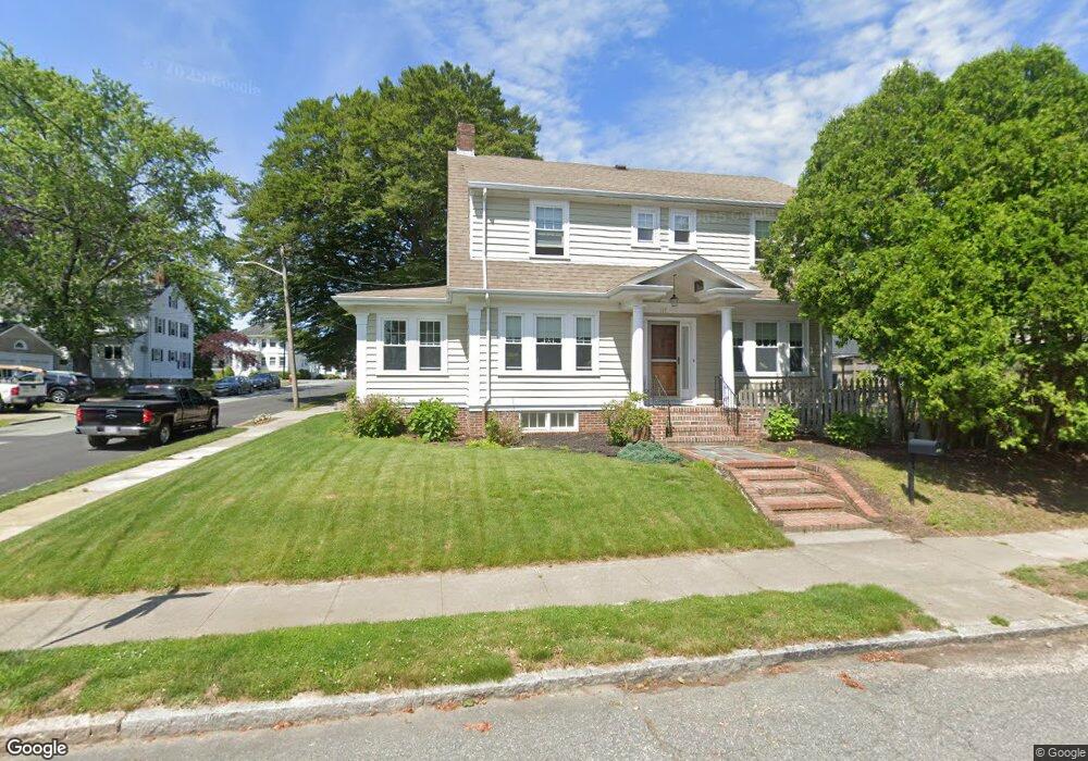
117 Reed St New Bedford, MA 02740
Downtown New Bedford NeighborhoodEstimated Value: $512,000 - $553,000
3
Beds
3
Baths
2,134
Sq Ft
$250/Sq Ft
Est. Value
About This Home
This home is located at 117 Reed St, New Bedford, MA 02740 and is currently estimated at $532,635, approximately $249 per square foot. 117 Reed St is a home located in Bristol County with nearby schools including Betsey B. Winslow Elementary School, Keith Middle School, and New Bedford High School.
Ownership History
Date
Name
Owned For
Owner Type
Purchase Details
Closed on
Jan 4, 2022
Sold by
Taylor Deborah L
Bought by
Deborah L Taylor Ret
Current Estimated Value
Purchase Details
Closed on
Jan 2, 1992
Sold by
Gartzman Rae
Bought by
Taylor Michael A and Taylor Deborah L
Create a Home Valuation Report for This Property
The Home Valuation Report is an in-depth analysis detailing your home's value as well as a comparison with similar homes in the area
Home Values in the Area
Average Home Value in this Area
Purchase History
| Date | Buyer | Sale Price | Title Company |
|---|---|---|---|
| Deborah L Taylor Ret | -- | None Available | |
| Deborah L Taylor Ret | -- | None Available | |
| Taylor Michael A | $163,000 | -- | |
| Taylor Michael A | $163,000 | -- |
Source: Public Records
Mortgage History
| Date | Status | Borrower | Loan Amount |
|---|---|---|---|
| Previous Owner | Taylor Michael A | $41,249 | |
| Previous Owner | Taylor Michael A | $54,000 | |
| Previous Owner | Taylor Michael A | $11,500 |
Source: Public Records
Tax History Compared to Growth
Tax History
| Year | Tax Paid | Tax Assessment Tax Assessment Total Assessment is a certain percentage of the fair market value that is determined by local assessors to be the total taxable value of land and additions on the property. | Land | Improvement |
|---|---|---|---|---|
| 2025 | $5,730 | $506,600 | $117,900 | $388,700 |
| 2024 | $5,724 | $477,000 | $112,300 | $364,700 |
| 2023 | $6,106 | $427,300 | $100,600 | $326,700 |
| 2022 | $5,537 | $356,300 | $95,800 | $260,500 |
| 2021 | $5,308 | $340,500 | $95,800 | $244,700 |
| 2020 | $5,140 | $318,100 | $99,400 | $218,700 |
| 2019 | $4,956 | $300,900 | $101,300 | $199,600 |
| 2018 | $4,590 | $276,000 | $101,300 | $174,700 |
| 2017 | $4,413 | $264,400 | $101,300 | $163,100 |
| 2016 | $4,167 | $252,700 | $95,800 | $156,900 |
| 2015 | $3,977 | $252,800 | $99,400 | $153,400 |
| 2014 | $3,831 | $252,700 | $101,300 | $151,400 |
Source: Public Records
Map
Nearby Homes
- 125 Reed St
- 107 Reed St
- 572 Rockdale Ave
- 161 Carroll St Unit 163
- 161 Carroll St Unit 2
- 80 Plymouth St Unit 82
- 560 Rockdale Ave
- 157 Carroll St Unit 159
- 78 Plymouth St
- 104 Reed St
- 99 Reed St
- 87 Plymouth St
- 95 Plymouth St
- 76 Plymouth St
- 134 Reed St
- 154 Carroll St
- 554 Rockdale Ave
- 151 Carroll St Unit 153
- 584 Rockdale Ave
- 77 Plymouth St