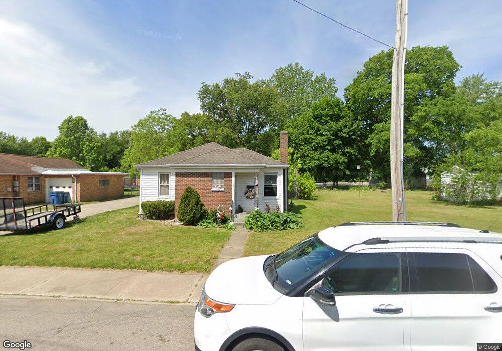
117 S Charles St Mishawaka, IN 46544
Estimated Value: $119,000 - $157,000
2
Beds
2
Baths
800
Sq Ft
$171/Sq Ft
Est. Value
About This Home
This home is located at 117 S Charles St, Mishawaka, IN 46544 and is currently estimated at $136,762, approximately $170 per square foot. 117 S Charles St is a home located in St. Joseph County with nearby schools including Twin Branch Elementary School, John J. Young Middle School, and Mishawaka High School.
Ownership History
Date
Name
Owned For
Owner Type
Purchase Details
Closed on
Mar 25, 2013
Sold by
Mcgovern Katrina
Bought by
Katom Llc
Current Estimated Value
Purchase Details
Closed on
Jul 30, 2004
Sold by
Bonney Kathryn E
Bought by
Bonney Kathryn E and Mcdavid Patricia
Purchase Details
Closed on
May 3, 2004
Sold by
Mcdavid Patricia and Reed Tina
Bought by
Wells Fargo Bank Na
Create a Home Valuation Report for This Property
The Home Valuation Report is an in-depth analysis detailing your home's value as well as a comparison with similar homes in the area
Home Values in the Area
Average Home Value in this Area
Purchase History
| Date | Buyer | Sale Price | Title Company |
|---|---|---|---|
| Katom Llc | -- | None Available | |
| Bonney Kathryn E | -- | None Available | |
| Wells Fargo Bank Na | $43,145 | None Available |
Source: Public Records
Tax History Compared to Growth
Tax History
| Year | Tax Paid | Tax Assessment Tax Assessment Total Assessment is a certain percentage of the fair market value that is determined by local assessors to be the total taxable value of land and additions on the property. | Land | Improvement |
|---|---|---|---|---|
| 2024 | $1,089 | $44,700 | $9,900 | $34,800 |
| 2023 | $1,175 | $46,400 | $9,900 | $36,500 |
| 2022 | $1,175 | $50,100 | $9,900 | $40,200 |
| 2021 | $1,104 | $58,300 | $10,900 | $47,400 |
| 2020 | $1,041 | $43,400 | $11,200 | $32,200 |
| 2019 | $985 | $47,900 | $10,500 | $37,400 |
| 2018 | $1,398 | $46,500 | $10,100 | $36,400 |
| 2017 | $1,569 | $48,400 | $10,100 | $38,300 |
| 2016 | $1,487 | $48,600 | $10,100 | $38,500 |
| 2014 | $1,209 | $44,700 | $8,700 | $36,000 |
Source: Public Records
Map
Nearby Homes
- 4207 Lincolnway E
- 12340 Lincoln Way E
- 135 Ray St
- 123 Oakside Ave
- 3623 Vistula Rd
- 3751 Terry Ln
- 318 Terry Ln
- 507 N Oakland Ave
- 3820 Cottage Ave
- 4326 Cassell Ave
- 157 Manor Dr
- 3362 York St
- 4607 Rivers Edge Dr
- 5116 Bankside Ct
- 705 Vistula Terrace Unit 1
- 2828 Lincolnway E
- 514 Ventura Dr
- 1101 Wellsley Ct
- 1119 Warrington Ct
- 4020 Stonegate Dr
- 125 S Charles St
- 131 S Charles St
- 3941 Lincoln Way E
- 3941 Lincolnway E
- 3947 Lincolnway E
- 133 S Charles St
- 139 S Charles St
- 3935 Lincolnway E
- 3930 Norton Ct
- 3939 Norton Ct
- 3919 Lincolnway Way E
- 3919 Lincolnway E
- 3937 Norton Ct
- 3941 Norton Ct
- 3945 Norton Ct
- 3935 Norton Ct
- 4001 Norton Ct
- 3936 E 3rd St
- 4013 Norton Ct
- 4019 Norton Ct