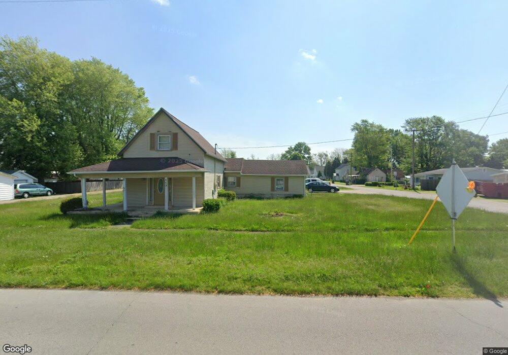
117 S Main St Sweetser, IN 46987
Estimated Value: $153,967 - $218,000
4
Beds
1
Bath
1,485
Sq Ft
$131/Sq Ft
Est. Value
About This Home
This home is located at 117 S Main St, Sweetser, IN 46987 and is currently estimated at $194,656, approximately $131 per square foot. 117 S Main St is a home located in Grant County with nearby schools including Converse Elementary School, Sweetser Elementary School, and Oak Hill Junior High School.
Ownership History
Date
Name
Owned For
Owner Type
Purchase Details
Closed on
Sep 8, 2009
Sold by
Dugo Building Corp
Bought by
Davis Phillip D and Davis Laura L
Current Estimated Value
Purchase Details
Closed on
Jan 3, 2008
Sold by
Wells Fargo Bank N A
Bought by
Diugo Building Corp
Purchase Details
Closed on
Jun 12, 2007
Sold by
Gerstorff Earl and Gerstorff Katherine
Bought by
Wells Fargo Bank Minnesota
Create a Home Valuation Report for This Property
The Home Valuation Report is an in-depth analysis detailing your home's value as well as a comparison with similar homes in the area
Purchase History
| Date | Buyer | Sale Price | Title Company |
|---|---|---|---|
| Davis Phillip D | $87,900 | Spitzer Herriman Stephenson | |
| Diugo Building Corp | -- | None Available | |
| Wells Fargo Bank Minnesota | $63,750 | None Available |
Source: Public Records
Mortgage History
| Date | Status | Borrower | Loan Amount |
|---|---|---|---|
| Closed | Davis Phillip D | $0 |
Source: Public Records
Tax History
| Year | Tax Paid | Tax Assessment Tax Assessment Total Assessment is a certain percentage of the fair market value that is determined by local assessors to be the total taxable value of land and additions on the property. | Land | Improvement |
|---|---|---|---|---|
| 2025 | $713 | $47,700 | $33,500 | $14,200 |
| 2024 | $713 | $47,700 | $33,500 | $14,200 |
| 2023 | $721 | $47,700 | $33,500 | $14,200 |
| 2022 | $863 | $47,700 | $23,800 | $23,900 |
| 2021 | $887 | $47,700 | $23,800 | $23,900 |
| 2020 | $833 | $47,700 | $23,800 | $23,900 |
| 2019 | $801 | $47,700 | $23,800 | $23,900 |
| 2018 | $782 | $47,700 | $23,800 | $23,900 |
| 2017 | $743 | $47,700 | $23,800 | $23,900 |
| 2016 | $716 | $47,900 | $23,800 | $24,100 |
| 2014 | $666 | $50,700 | $23,300 | $27,400 |
| 2013 | $666 | $59,200 | $23,300 | $35,900 |
Source: Public Records
Map
Nearby Homes
- 218 Greenberry St
- 203 Eagle Dr
- 514 Allen Dr
- 5292 W Delphi Pike
- 509 Nancy Dr
- 716 Allen Dr
- 1252 S 600 W
- 316 N Miller Ave
- 2111 W Euclid Ave
- 2151 W Woodview Dr
- 2112 W 6th St
- 304 N Norton Ave
- 303 S Lenfesty Ave
- 2107 W 8th St
- 3576 W 505 N
- 1501 W Forest Ln
- 0 W Kem Rd Unit 202548894
- 1807 W Wenlock Dr
- 1101 W Riga Ave
- 102 S Bradner Ave
- 111 E Franklin St
- 111 S Main St
- 105 S Main St
- 112 E Franklin St
- 100 E Franklin St
- 103 S Main St
- 103 S Main St
- 116 E Franklin St
- 118 E Pennsylvania St
- 121 E Franklin St
- 118 E Franklin St
- 102 S Main St
- 113 Walnut St
- 118 Bragg St
- 124 E Franklin St
- 123 Walnut St
- 214 S Main St
- 216 S Main St
- 219 S Main St
- 116 Pennsylvania St
Your Personal Tour Guide
Ask me questions while you tour the home.