
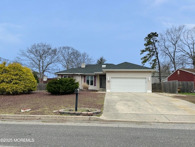
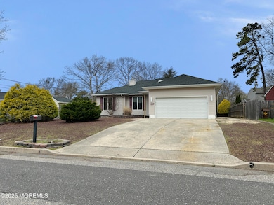
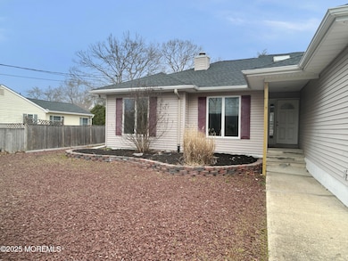
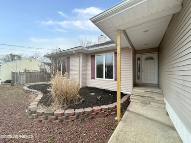
117 Topside Rd Manahawkin, NJ 08050
Stafford NeighborhoodEstimated payment $3,044/month
Highlights
- Deck
- No HOA
- Tankless Water Heater
- 1 Fireplace
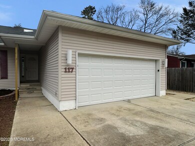
- 2 Car Attached Garage
- Central Air
About This Home
Welcome to this beautifully maintained 3-bedroom, 2-bathroom home located in one of the area's most sought-after neighborhoods. Offering comfort, space, and close to everyday amenities.
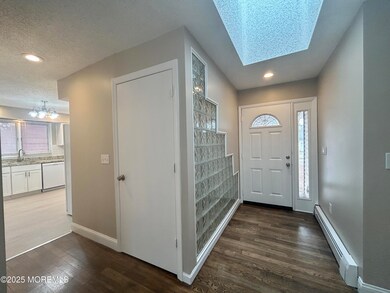
Living room features a cozy fireplace—ideal for relaxing evenings. The modern kitchen boasts sleek finishes and ample cabinet space.
The home includes two full bathrooms and three bedrooms that provide plenty of room to unwind.
An unfinished basement offers endless possibilities for future expansion, whether you're dreaming of a home gym, media room, or additional storage space.
Outside, enjoy your private backyard oasis with a large deck—perfect for entertaining or enjoying quiet mornings. Mature trees surround the yard, providing privacy and a serene natural setting. Additional features include a spacious two-car garage and close proximity to local stores, dining, and the hospitaleverything you need is just minutes away.
Don't miss your chance to own this move-in-ready gem in a prime location.
Home Details
Home Type
- Single Family
Est. Annual Taxes
- $5,612
Year Built
- Built in 1992
Parking
- 2 Car Attached Garage
Home Design
- Shingle Roof
Interior Spaces
- 1-Story Property
- 1 Fireplace
- Unfinished Basement
Kitchen
- Stove
- Microwave
- Dishwasher
Bedrooms and Bathrooms
- 3 Bedrooms
- 2 Full Bathrooms
Schools
- Ocean Acres Elementary School
- Southern Reg Middle School
- Southern Reg High School
Utilities
- Central Air
- Baseboard Heating
- Well
- Tankless Water Heater
Additional Features
- Deck
- Lot Dimensions are 75 x 120
Community Details
- No Home Owners Association
- Ocean Acres Subdivision
Listing and Financial Details
- Assessor Parcel Number 31-00044-154-00032
Map
Home Values in the Area
Average Home Value in this Area
Tax History
| Year | Tax Paid | Tax Assessment Tax Assessment Total Assessment is a certain percentage of the fair market value that is determined by local assessors to be the total taxable value of land and additions on the property. | Land | Improvement |
|---|---|---|---|---|
| 2025 | $5,612 | $226,000 | $61,600 | $164,400 |
| 2024 | $5,557 | $226,000 | $61,600 | $164,400 |
| 2023 | $5,320 | $226,000 | $61,600 | $164,400 |
| 2022 | $5,320 | $226,000 | $61,600 | $164,400 |
| 2021 | $5,248 | $226,000 | $61,600 | $164,400 |
| 2020 | $5,255 | $226,000 | $61,600 | $164,400 |
| 2019 | $5,180 | $226,000 | $61,600 | $164,400 |
| 2018 | $5,148 | $226,000 | $61,600 | $164,400 |
| 2017 | $4,850 | $206,100 | $61,600 | $144,500 |
| 2016 | $4,550 | $206,100 | $61,600 | $144,500 |
| 2015 | $4,381 | $206,100 | $61,600 | $144,500 |
| 2014 | $4,314 | $200,600 | $60,800 | $139,800 |
Property History
| Date | Event | Price | List to Sale | Price per Sq Ft |
|---|---|---|---|---|
| 10/03/2025 10/03/25 | Pending | -- | -- | -- |
| 09/05/2025 09/05/25 | Price Changed | $489,900 | -3.0% | -- |
| 08/07/2025 08/07/25 | For Sale | $504,900 | -- | -- |
Purchase History
| Date | Type | Sale Price | Title Company |
|---|---|---|---|
| Deed | $205,000 | None Available | |
| Deed | $130,000 | -- |
Mortgage History
| Date | Status | Loan Amount | Loan Type |
|---|---|---|---|
| Previous Owner | $55,000 | No Value Available |
Source: MOREMLS (Monmouth Ocean Regional REALTORS®)
MLS Number: 22523805
APN: 31-00044-154-00032
Disclaimer: Certain information contained herein is derived from information provided by parties other than Homes.com. All information provided is deemed reliable, but is not guaranteed to be accurate and should be independently verified.
![]() IDX information is provided exclusively for personal, non-commercial use, and may not be used for any purpose other than to identify prospective properties consumers may be interested in purchasing.
IDX information is provided exclusively for personal, non-commercial use, and may not be used for any purpose other than to identify prospective properties consumers may be interested in purchasing.
Information is deemed reliable but not guaranteed.
- 225 Yeoman Rd
- 246 Atlantis Ave
- 309 Neptune Dr
- 182 Atlantis Ave
- 296 Neptune Dr
- 181 Bowline Rd
- 100 Marlin Rd
- 137 Skipper Rd
- 101 Topsail Ln
- 248 Mizzen Ave
- 112 Castaway Rd
- 113 Toggle Rd
- 139 Mermaid Dr
- 223 Serpent Ln
- 169 Stowaway Rd
- 220 Middie Ln
- 1186 Galley Ave
- 217 Middie Ln
- 1034 Buccaneer Ln
- 164 Nautilus Dr
