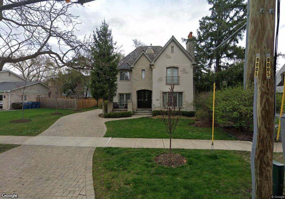
117 W North St Hinsdale, IL 60521
North Hinsdale NeighborhoodEstimated Value: $1,704,000 - $2,217,000
5
Beds
6
Baths
3,177
Sq Ft
$615/Sq Ft
Est. Value
About This Home
This home is located at 117 W North St, Hinsdale, IL 60521 and is currently estimated at $1,953,584, approximately $614 per square foot. 117 W North St is a home located in DuPage County with nearby schools including Monroe Elementary School, Clarendon Hills Middle School, and Hinsdale Central High School.
Ownership History
Date
Name
Owned For
Owner Type
Purchase Details
Closed on
Mar 1, 2021
Sold by
Harnois Beatriz and Harnois Peter T
Bought by
Harnois Beatriz
Current Estimated Value
Home Financials for this Owner
Home Financials are based on the most recent Mortgage that was taken out on this home.
Original Mortgage
$703,000
Outstanding Balance
$631,990
Interest Rate
2.87%
Mortgage Type
New Conventional
Estimated Equity
$1,321,594
Purchase Details
Closed on
Jun 15, 2012
Sold by
Dst Management Llc
Bought by
Harnois Peter T
Home Financials for this Owner
Home Financials are based on the most recent Mortgage that was taken out on this home.
Original Mortgage
$840,000
Interest Rate
3.87%
Mortgage Type
New Conventional
Purchase Details
Closed on
May 13, 2009
Sold by
Catarama Veronica
Bought by
Dst Management Llc
Purchase Details
Closed on
Aug 23, 2005
Sold by
Western Springs National Bank & Trust
Bought by
Catarama Veronica
Home Financials for this Owner
Home Financials are based on the most recent Mortgage that was taken out on this home.
Original Mortgage
$990,000
Interest Rate
5.25%
Mortgage Type
Construction
Purchase Details
Closed on
Feb 21, 2005
Sold by
Pop Mioara
Bought by
Western Springs National Bank & Trust and Trust #4062
Home Financials for this Owner
Home Financials are based on the most recent Mortgage that was taken out on this home.
Original Mortgage
$441,000
Interest Rate
7.55%
Mortgage Type
Purchase Money Mortgage
Purchase Details
Closed on
Dec 30, 2004
Sold by
Timson Dean and Timson Bridget
Bought by
Pop Mioara
Home Financials for this Owner
Home Financials are based on the most recent Mortgage that was taken out on this home.
Original Mortgage
$441,000
Interest Rate
7.55%
Mortgage Type
Purchase Money Mortgage
Purchase Details
Closed on
Sep 24, 2001
Sold by
Timson Eldred
Bought by
Timson Dean and Timson Bridget
Home Financials for this Owner
Home Financials are based on the most recent Mortgage that was taken out on this home.
Original Mortgage
$237,511
Interest Rate
5.99%
Mortgage Type
Seller Take Back
Purchase Details
Closed on
Jul 15, 2001
Sold by
Timson Eldred
Bought by
Timson Dean and Timson Bridget
Create a Home Valuation Report for This Property
The Home Valuation Report is an in-depth analysis detailing your home's value as well as a comparison with similar homes in the area
Home Values in the Area
Average Home Value in this Area
Purchase History
| Date | Buyer | Sale Price | Title Company |
|---|---|---|---|
| Harnois Beatriz | -- | Ravenswood Title Company Llc | |
| Harnois Peter T | $1,050,000 | Success Title Services Inc | |
| Dst Management Llc | $950,000 | First American Title | |
| Catarama Veronica | $630,000 | First American Title | |
| Western Springs National Bank & Trust | -- | -- | |
| Pop Mioara | $490,000 | First American Title | |
| Timson Dean | $400,000 | -- | |
| Timson Dean | $400,000 | -- |
Source: Public Records
Mortgage History
| Date | Status | Borrower | Loan Amount |
|---|---|---|---|
| Open | Harnois Beatriz | $703,000 | |
| Closed | Harnois Peter T | $840,000 | |
| Previous Owner | Catarama Veronica | $990,000 | |
| Previous Owner | Pop Mioara | $441,000 | |
| Previous Owner | Timson Dean | $237,511 | |
| Closed | Timson Dean | -- |
Source: Public Records
Tax History Compared to Growth
Tax History
| Year | Tax Paid | Tax Assessment Tax Assessment Total Assessment is a certain percentage of the fair market value that is determined by local assessors to be the total taxable value of land and additions on the property. | Land | Improvement |
|---|---|---|---|---|
| 2024 | $25,836 | $498,375 | $101,818 | $396,557 |
| 2023 | $24,606 | $458,150 | $93,600 | $364,550 |
| 2022 | $24,362 | $464,660 | $94,930 | $369,730 |
| 2021 | $23,479 | $459,380 | $93,850 | $365,530 |
| 2020 | $22,954 | $450,280 | $91,990 | $358,290 |
| 2019 | $22,984 | $432,040 | $88,260 | $343,780 |
| 2018 | $22,459 | $437,620 | $87,790 | $349,830 |
| 2017 | $21,660 | $421,110 | $84,480 | $336,630 |
| 2016 | $21,263 | $401,900 | $80,630 | $321,270 |
| 2015 | $21,195 | $378,120 | $75,860 | $302,260 |
| 2014 | $20,093 | $345,870 | $73,760 | $272,110 |
| 2013 | $19,703 | $344,250 | $73,410 | $270,840 |
Source: Public Records
Map
Nearby Homes
- 210 W Hickory St
- 123 N Vine St
- 118 N Grant St
- 216 Bonnie Brae Rd
- 539 Kensington Ct
- 527 Kensington Ct
- 531 N York Rd
- 117 N Monroe St
- 415 N Adams St
- 28 S Clay St
- 14 S Thurlow St
- 317 E Walnut St
- 401 Birchwood Rd
- 11S110 LOT Madison St
- 6 S Elm St
- 125 S Madison St
- 719 N Elm St
- 13 S Elm St
- 401 Glendale Ave
- 329 N Oak St
- 123 W North St
- 404 N Lincoln St
- 411 N Grant St
- 411 N Grant St
- 416 N Lincoln St
- 122 W North St
- 417 N Grant St
- 330 N Lincoln St
- 323 N Grant St
- 420 N Lincoln St
- 421 N Grant St
- 326 N Lincoln St
- 203 W North St
- 414 N Grant St
- 120 W Ayres St
- 428 N Lincoln St
- 319 N Grant St
- 318 N Lincoln St
- 330 N Grant St
- 326 N Grant St