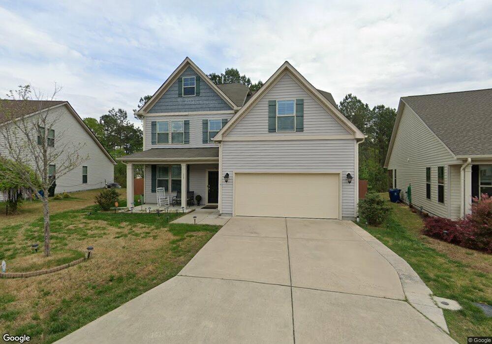
117 Waxwing Dr Durham, NC 27704
Eastern Durham NeighborhoodEstimated Value: $399,000 - $462,000
3
Beds
3
Baths
2,464
Sq Ft
$171/Sq Ft
Est. Value
About This Home
This home is located at 117 Waxwing Dr, Durham, NC 27704 and is currently estimated at $420,269, approximately $170 per square foot. 117 Waxwing Dr is a home with nearby schools including Glenn Elementary, John W Neal Middle School, and Southern School of Energy & Sustainability.
Ownership History
Date
Name
Owned For
Owner Type
Purchase Details
Closed on
Aug 28, 2017
Sold by
Level Carolina Homes Llc
Bought by
Blackmon Edward R and Blackmon Vergia Kemp
Current Estimated Value
Home Financials for this Owner
Home Financials are based on the most recent Mortgage that was taken out on this home.
Original Mortgage
$164,800
Outstanding Balance
$138,098
Interest Rate
4.03%
Mortgage Type
New Conventional
Estimated Equity
$282,171
Purchase Details
Closed on
Mar 30, 2017
Sold by
Not Provided
Bought by
Level Carolina Homes Llc
Create a Home Valuation Report for This Property
The Home Valuation Report is an in-depth analysis detailing your home's value as well as a comparison with similar homes in the area
Home Values in the Area
Average Home Value in this Area
Purchase History
| Date | Buyer | Sale Price | Title Company |
|---|---|---|---|
| Blackmon Edward R | $241,500 | None Available | |
| Level Carolina Homes Llc | $216,000 | -- |
Source: Public Records
Mortgage History
| Date | Status | Borrower | Loan Amount |
|---|---|---|---|
| Open | Blackmon Edward R | $164,800 |
Source: Public Records
Tax History
| Year | Tax Paid | Tax Assessment Tax Assessment Total Assessment is a certain percentage of the fair market value that is determined by local assessors to be the total taxable value of land and additions on the property. | Land | Improvement |
|---|---|---|---|---|
| 2025 | $4,653 | $469,409 | $72,500 | $396,909 |
| 2024 | $3,469 | $248,685 | $34,860 | $213,825 |
| 2023 | $3,258 | $248,685 | $34,860 | $213,825 |
| 2022 | $3,183 | $248,685 | $34,860 | $213,825 |
| 2021 | $3,168 | $248,685 | $34,860 | $213,825 |
| 2020 | $3,093 | $248,685 | $34,860 | $213,825 |
| 2019 | $3,093 | $248,685 | $34,860 | $213,825 |
| 2018 | $3,444 | $253,887 | $43,575 | $210,312 |
| 2017 | $587 | $43,575 | $43,575 | $0 |
Source: Public Records
Map
Nearby Homes
- 3515 Cheek Rd
- 3513 Cheek Rd
- 1213 Opal Ln
- 4300-4304 Cheek Rd
- 1201 Opal Ln
- 3515 Mountain Brook Cir
- 603 Timber Terrace Dr
- 3034 Hammer Creek Rd
- 4144 Rustic Ridge Dr
- 3022 Hammer Creek Rd
- 1135 Sawmill Grove Dr
- 1136 Sawmill Grove Dr
- 1127 Sawmill Grove Dr
- 1206 Sawmill Grove Dr
- 1113 Sawmill Grove Dr
- 3721 Mountain Brook Cir
- 3719 Mountain Brook Cir
- 3032 Hammer Creek Rd
- 20 Hidden Meadow Ct
- 1215 Carpenter Falls Ave
- 113 Waxwing Dr
- 119 Waxwing Dr
- 111 Waxwing Dr
- 114 Waxwing Dr
- 203 Snowy Egret Ct
- 205 Snowy Egret Ct
- 109 Waxwing Dr
- 207 Snowy Egret Ct
- 117 Snowy Egret Ct
- 108 Waxwing Dr
- 209 Snowy Egret Ct
- 107 Waxwing Dr
- 113 Snowy Egret Ct
- 106 Waxwing Dr
- 310 Kinnakeet Dr
- 308 Kinnakeet Dr
- 109 Snowy Egret Ct
- 211 Snowy Egret Ct
- 314 Kinnakeet Dr
- 105 Waxwing Dr
Your Personal Tour Guide
Ask me questions while you tour the home.