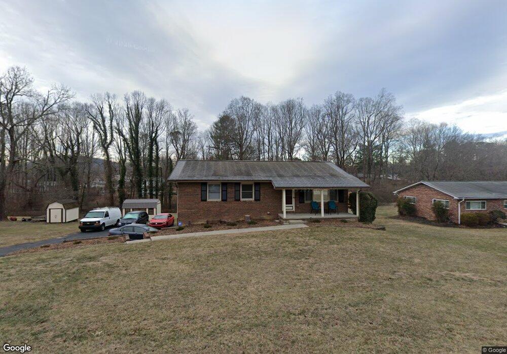
117 Wynnbrook Dr Hendersonville, NC 28792
Estimated Value: $312,000 - $402,000
3
Beds
2
Baths
1,222
Sq Ft
$287/Sq Ft
Est. Value
About This Home
This home is located at 117 Wynnbrook Dr, Hendersonville, NC 28792 and is currently estimated at $350,605, approximately $286 per square foot. 117 Wynnbrook Dr is a home located in Henderson County with nearby schools including Clear Creek Elementary School, Apple Valley Middle School, and North Henderson High School.
Ownership History
Date
Name
Owned For
Owner Type
Purchase Details
Closed on
Aug 18, 2016
Sold by
Baldwin Marian V
Bought by
Graham Carl J and Graham Kimberly T
Current Estimated Value
Home Financials for this Owner
Home Financials are based on the most recent Mortgage that was taken out on this home.
Original Mortgage
$186,500
Outstanding Balance
$152,013
Interest Rate
4.25%
Mortgage Type
New Conventional
Estimated Equity
$198,592
Create a Home Valuation Report for This Property
The Home Valuation Report is an in-depth analysis detailing your home's value as well as a comparison with similar homes in the area
Home Values in the Area
Average Home Value in this Area
Purchase History
| Date | Buyer | Sale Price | Title Company |
|---|---|---|---|
| Graham Carl J | $185,000 | -- |
Source: Public Records
Mortgage History
| Date | Status | Borrower | Loan Amount |
|---|---|---|---|
| Open | Graham Carl J | $186,500 |
Source: Public Records
Tax History Compared to Growth
Tax History
| Year | Tax Paid | Tax Assessment Tax Assessment Total Assessment is a certain percentage of the fair market value that is determined by local assessors to be the total taxable value of land and additions on the property. | Land | Improvement |
|---|---|---|---|---|
| 2025 | $1,463 | $268,000 | $68,200 | $199,800 |
| 2024 | $1,463 | $268,000 | $68,200 | $199,800 |
| 2023 | $1,463 | $268,000 | $68,200 | $199,800 |
| 2022 | $1,329 | $195,100 | $55,400 | $139,700 |
| 2021 | $1,329 | $195,100 | $55,400 | $139,700 |
| 2020 | $1,329 | $195,100 | $0 | $0 |
| 2019 | $1,271 | $186,700 | $0 | $0 |
| 2018 | $804 | $117,300 | $0 | $0 |
| 2017 | $804 | $117,300 | $0 | $0 |
| 2016 | $402 | $58,650 | $0 | $0 |
| 2015 | -- | $58,650 | $0 | $0 |
| 2014 | -- | $56,550 | $0 | $0 |
Source: Public Records
Map
Nearby Homes
- 65 Brookside Dr Unit 35
- 1042 Brookside Camp Rd
- 103 Oakwood Place Unit 3
- 103 Oakwood Place Unit 4
- 231 Kimberly Ann Dr
- 125 Fulton Dr
- 111 Laura Trace
- 208 Bragg Ct
- 324 Whispering Hills Dr
- 49 Gosling Cir E
- 0 Empress Ln
- 3204 Hickory Hill Rd
- 701 Salisbury Rd
- 21 Fox Run Dr
- 3119 Hickory Hill Rd
- 3224 Hickory Hill Rd
- 3017 Chestnut Tree Rd
- 256 Burge Mountain Rd
- 2049 Brookside Camp Rd
- 530 Burge Mountain Rd
- 105 Wynnbrook Dr
- 119 Wynnbrook Dr
- 116 Wynnbrook Dr
- 101 Wynnbrook Dr
- 120 Wynnbrook Dr
- 125 Wynnbrook Dr
- 113 Joyce Rd
- 126 Wynnbrook Dr
- 114 Joanne Ln
- 806 Brookside Camp Rd
- 102 Wynnbrook Dr
- 74 Brookside Dr
- 131 Wynnbrook Dr
- 100 Brookside Dr
- 116 Joanne Ln
- 132 Wynnbrook Dr
- 124 Brookside Dr
- 112 Joyce Rd
- 54 Brookside Dr
- 50 Brookside Dr