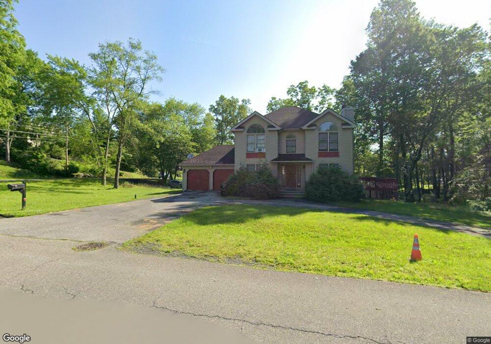
1170 Butternut Ln Stroudsburg, PA 18360
Estimated Value: $384,668 - $446,000
4
Beds
4
Baths
1,888
Sq Ft
$221/Sq Ft
Est. Value
About This Home
This home is located at 1170 Butternut Ln, Stroudsburg, PA 18360 and is currently estimated at $418,167, approximately $221 per square foot. 1170 Butternut Ln is a home with nearby schools including Stroudsburg Junior High School, Stroudsburg High School, and Stroudsburg Seventh-day Adventist School.
Ownership History
Date
Name
Owned For
Owner Type
Purchase Details
Closed on
Apr 23, 2024
Sold by
Frisby Rondu
Bought by
Rondu Gary Frisby Living Trust and Frisby
Current Estimated Value
Purchase Details
Closed on
Nov 5, 2007
Sold by
Taylor Sharon M
Bought by
Frisby Rondu
Home Financials for this Owner
Home Financials are based on the most recent Mortgage that was taken out on this home.
Original Mortgage
$172,250
Interest Rate
6.41%
Mortgage Type
New Conventional
Create a Home Valuation Report for This Property
The Home Valuation Report is an in-depth analysis detailing your home's value as well as a comparison with similar homes in the area
Home Values in the Area
Average Home Value in this Area
Purchase History
| Date | Buyer | Sale Price | Title Company |
|---|---|---|---|
| Rondu Gary Frisby Living Trust | -- | -- | |
| Frisby Rondu | $298,000 | None Available |
Source: Public Records
Mortgage History
| Date | Status | Borrower | Loan Amount |
|---|---|---|---|
| Previous Owner | Frisby Rondu | $172,250 |
Source: Public Records
Tax History Compared to Growth
Tax History
| Year | Tax Paid | Tax Assessment Tax Assessment Total Assessment is a certain percentage of the fair market value that is determined by local assessors to be the total taxable value of land and additions on the property. | Land | Improvement |
|---|---|---|---|---|
| 2025 | $1,511 | $183,300 | $41,000 | $142,300 |
| 2024 | $1,236 | $183,300 | $41,000 | $142,300 |
| 2023 | $6,119 | $183,300 | $41,000 | $142,300 |
| 2022 | $6,247 | $183,300 | $41,000 | $142,300 |
| 2021 | $6,056 | $183,300 | $41,000 | $142,300 |
| 2020 | $5,973 | $183,300 | $41,000 | $142,300 |
| 2019 | $6,577 | $34,880 | $6,000 | $28,880 |
| 2018 | $7,016 | $34,880 | $6,000 | $28,880 |
| 2017 | $7,016 | $34,880 | $6,000 | $28,880 |
| 2016 | $1,320 | $34,880 | $6,000 | $28,880 |
| 2015 | -- | $34,880 | $6,000 | $28,880 |
| 2014 | -- | $34,880 | $6,000 | $28,880 |
Source: Public Records
Map
Nearby Homes
- 1191 Appenzeller Ave
- 1184 Appenzeller Ave
- 00 Phillips St
- 2215 Sutton Dr
- 412 N 8th St
- 110 Kraemer Ave
- 144 W Broad St
- LOT Edgemont Rd
- 712 Scott St
- 830 Scott St
- 520 Scott St
- 3 Oakland Ave
- 1 Oakland Ave
- 64 N 2nd St Unit A
- 720 Stokes Mill Rd
- 712 Thomas St
- 818 Thomas St
- 607 Thomas St
- 507 Thomas St
- 25 N 2nd St