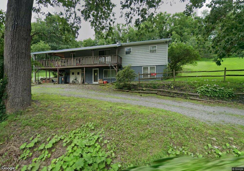
1170 State Route 1018 Dayton, PA 16222
Wayne Township NeighborhoodEstimated Value: $112,459 - $204,000
2
Beds
1
Bath
1,274
Sq Ft
$125/Sq Ft
Est. Value
About This Home
This home is located at 1170 State Route 1018, Dayton, PA 16222 and is currently estimated at $159,865, approximately $125 per square foot. 1170 State Route 1018 is a home located in Armstrong County with nearby schools including Dayton Elementary School, Shannock Valley Elementary Schoo, and Elderton Elementary School.
Ownership History
Date
Name
Owned For
Owner Type
Purchase Details
Closed on
Sep 29, 2017
Sold by
Bussard Ricky L and Bussard Jacqueline S
Bought by
Placek Edward
Current Estimated Value
Home Financials for this Owner
Home Financials are based on the most recent Mortgage that was taken out on this home.
Original Mortgage
$103,030
Outstanding Balance
$86,220
Interest Rate
3.89%
Mortgage Type
New Conventional
Estimated Equity
$73,645
Purchase Details
Closed on
Sep 24, 1999
Bought by
Bussard Ricky L and Bussard Jacqueline S
Create a Home Valuation Report for This Property
The Home Valuation Report is an in-depth analysis detailing your home's value as well as a comparison with similar homes in the area
Home Values in the Area
Average Home Value in this Area
Purchase History
| Date | Buyer | Sale Price | Title Company |
|---|---|---|---|
| Placek Edward | $101,000 | None Available | |
| Bussard Ricky L | $55,000 | -- |
Source: Public Records
Mortgage History
| Date | Status | Borrower | Loan Amount |
|---|---|---|---|
| Open | Placek Edward | $103,030 |
Source: Public Records
Tax History Compared to Growth
Tax History
| Year | Tax Paid | Tax Assessment Tax Assessment Total Assessment is a certain percentage of the fair market value that is determined by local assessors to be the total taxable value of land and additions on the property. | Land | Improvement |
|---|---|---|---|---|
| 2025 | $1,625 | $19,290 | $11,200 | $8,090 |
| 2024 | $1,529 | $19,290 | $11,200 | $8,090 |
| 2023 | $1,269 | $19,290 | $11,200 | $8,090 |
| 2022 | $1,269 | $19,290 | $11,200 | $8,090 |
| 2021 | $1,269 | $19,290 | $11,200 | $8,090 |
| 2020 | $1,269 | $19,290 | $11,200 | $8,090 |
| 2019 | $1,269 | $19,290 | $11,200 | $8,090 |
| 2018 | $1,267 | $16,007 | $4,445 | $11,562 |
| 2017 | $1,257 | $19,290 | $11,200 | $8,090 |
| 2016 | $1,257 | $19,290 | $11,200 | $8,090 |
| 2015 | $1,117 | $19,290 | $11,200 | $8,090 |
| 2014 | $1,117 | $19,290 | $11,200 | $8,090 |
Source: Public Records
Map
Nearby Homes
- 273 Government Rd
- 0 Boat Launch Rd
- 00 Boat Launch Rd
- 00 N Loop Rd
- 160 W Main St
- 0 Sinktown Rd Unit 1722109
- 0 Sinktown Rd Unit 1722108
- 0 Sinktown Rd Unit 1722107
- 2444/2448 Dayton Rd
- 1175 State Route 1028
- 515 Hoover Rd
- 0 Maple Rd
- 109 3rd St
- 0 Lower Mudlic Rd
- 319 Farm Rd
- 217 Salem Rd
- 622 State Route 839
- 539 Ridge Rd
- 3162 Route 28 66
- 119 Kohlersburg Rd
- 1170 State Route 1018
- 1170 State Route 1018
- 1159 State Route 1018
- 1188 State Route 1018
- 156 Reform Rd
- 100 School House Rd
- 649 Country Rd
- 153 State Route 1025
- 233 Belknap Rd
- 158 State Route 1025
- 167 State Route 1025
- 248 Belknap Rd
- 1099 State Route 1018
- 1097 State Route 1018
- 597 Country Rd
- 582 Country Rd
- 275 Belknap Rd
- 280 Belknap Rd
- 1270 State Route 1018
- 121 School House Rd