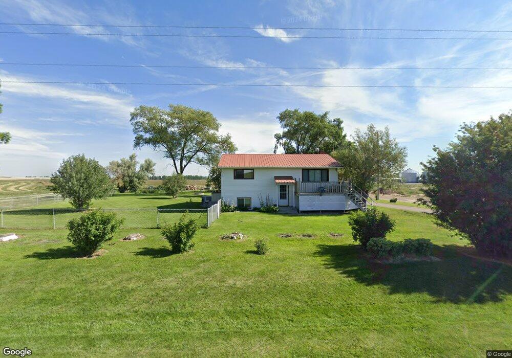
1170 W 81st N Idaho Falls, ID 83402
Estimated Value: $375,000 - $452,000
4
Beds
2
Baths
1,701
Sq Ft
$243/Sq Ft
Est. Value
About This Home
This home is located at 1170 W 81st N, Idaho Falls, ID 83402 and is currently estimated at $413,604, approximately $243 per square foot. 1170 W 81st N is a home located in Bonneville County with nearby schools including Westside Elementary School, Eagle Rock Middle School, and Skyline Senior High School.
Ownership History
Date
Name
Owned For
Owner Type
Purchase Details
Closed on
Jan 11, 2023
Sold by
Morris Lorraine V
Bought by
Lorraine V Morris Family Trust
Current Estimated Value
Purchase Details
Closed on
Nov 18, 2022
Sold by
Morris Lorraine V
Bought by
Lorraine V Morris Family Trust
Purchase Details
Closed on
Jun 30, 2022
Sold by
Morris Lorraine V
Bought by
Morris Lorraine V
Create a Home Valuation Report for This Property
The Home Valuation Report is an in-depth analysis detailing your home's value as well as a comparison with similar homes in the area
Home Values in the Area
Average Home Value in this Area
Purchase History
| Date | Buyer | Sale Price | Title Company |
|---|---|---|---|
| Lorraine V Morris Family Trust | -- | -- | |
| Lorraine V Morris Family Trust | -- | -- | |
| Morris Lorraine V | -- | None Listed On Document |
Source: Public Records
Tax History Compared to Growth
Tax History
| Year | Tax Paid | Tax Assessment Tax Assessment Total Assessment is a certain percentage of the fair market value that is determined by local assessors to be the total taxable value of land and additions on the property. | Land | Improvement |
|---|---|---|---|---|
| 2025 | $759 | $318,650 | $1,200 | $317,450 |
| 2024 | $759 | $285,970 | $690 | $285,280 |
| 2023 | $820 | $315,770 | $64,190 | $251,580 |
| 2022 | $1,050 | $264,660 | $59,190 | $205,470 |
| 2021 | $758 | $173,810 | $59,190 | $114,620 |
| 2019 | $827 | $146,180 | $47,190 | $98,990 |
| 2018 | $760 | $146,820 | $46,190 | $100,630 |
| 2017 | $725 | $130,150 | $41,190 | $88,960 |
| 2016 | $683 | $123,350 | $38,190 | $85,160 |
| 2015 | $647 | $106,910 | $38,190 | $68,720 |
| 2014 | $2,717 | $106,910 | $31,190 | $75,720 |
| 2013 | $681 | $113,870 | $31,190 | $82,680 |
Source: Public Records
Map
Nearby Homes
- TBD N Riverfront Dr
- 8073 N Riverfront Dr
- TBD N River Rd
- 200 W Commons Rd
- 408 Tapitio Dr
- 6111 Bay Hill Dr
- 974 W Riverview Dr
- 299 Lacosta Dr
- 6469 Ender Ln
- 6455 Ender Ln
- 6439 Ender Ln
- 6425 Ender Ln
- 6409 Ender Ln
- 6395 Ender Ln
- 275 Birdie Thompson Dr
- 6349 Ender Ln
- 6410 Ender Ln
- 6394 Ender Ln
- L19&20B4 Achilles Ave
- L24&25B5 Achilles Ave