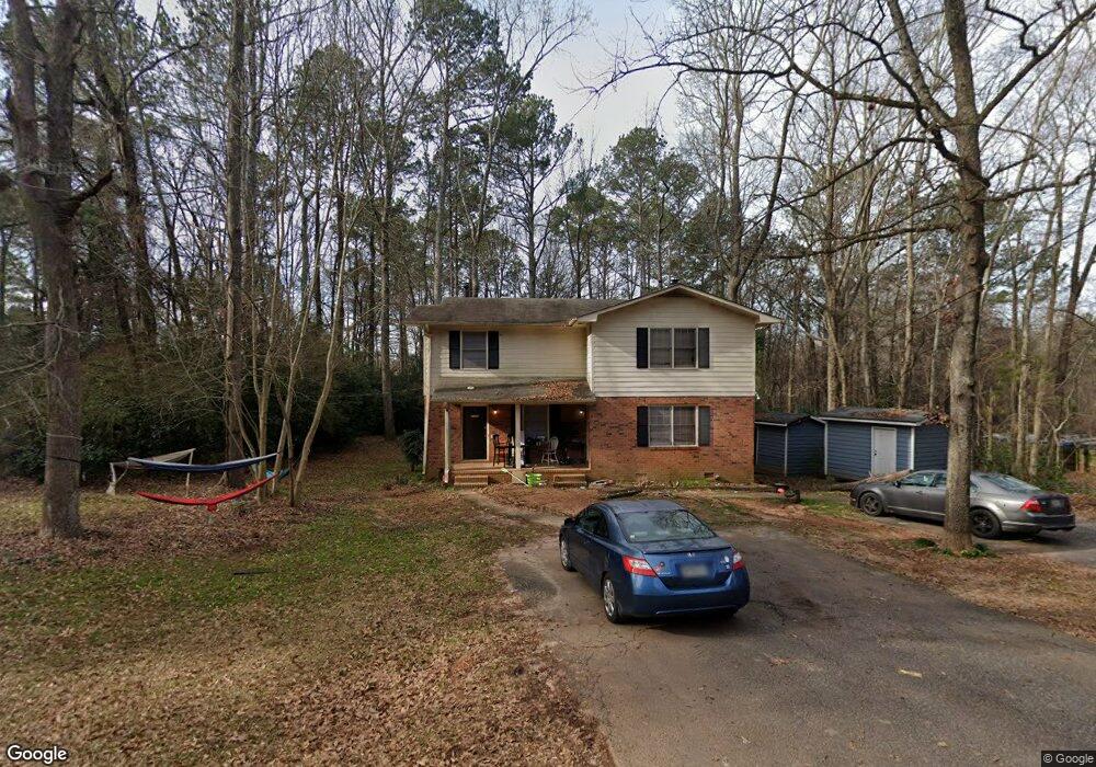
1170 Whit Davis Rd Athens, GA 30605
Estimated Value: $296,106 - $394,000
--
Bed
3
Baths
2,380
Sq Ft
$141/Sq Ft
Est. Value
About This Home
This home is located at 1170 Whit Davis Rd, Athens, GA 30605 and is currently estimated at $335,527, approximately $140 per square foot. 1170 Whit Davis Rd is a home located in Clarke County with nearby schools including Whit Davis Road Elementary School, Hilsman Middle School, and Cedar Shoals High School.
Ownership History
Date
Name
Owned For
Owner Type
Purchase Details
Closed on
Feb 9, 2016
Sold by
Souths Best Development Co
Bought by
Pleasant Point Properties Inc
Current Estimated Value
Purchase Details
Closed on
Jun 24, 2004
Sold by
1170 1172 Wdr Land Trust
Bought by
Souths Best Development Corp
Purchase Details
Closed on
Oct 25, 2002
Sold by
Souths Best Development Corpor
Bought by
1170 1172 Wdr Land Trust
Purchase Details
Closed on
Apr 2, 1999
Sold by
1150 1152 1160 1162 1170 1172 W D R
Bought by
Souths Best Development Corporation
Purchase Details
Closed on
Apr 18, 1995
Sold by
Souths Best Development Corp
Bought by
1150 1152 1160 1162 1170 1172 W D R
Create a Home Valuation Report for This Property
The Home Valuation Report is an in-depth analysis detailing your home's value as well as a comparison with similar homes in the area
Home Values in the Area
Average Home Value in this Area
Purchase History
| Date | Buyer | Sale Price | Title Company |
|---|---|---|---|
| Pleasant Point Properties Inc | -- | -- | |
| Souths Best Development Corp | -- | -- | |
| 1170 1172 Wdr Land Trust | -- | -- | |
| Souths Best Development Corporation | -- | -- | |
| 1150 1152 1160 1162 1170 1172 W D R | -- | -- |
Source: Public Records
Tax History Compared to Growth
Tax History
| Year | Tax Paid | Tax Assessment Tax Assessment Total Assessment is a certain percentage of the fair market value that is determined by local assessors to be the total taxable value of land and additions on the property. | Land | Improvement |
|---|---|---|---|---|
| 2024 | $3,011 | $92,857 | $12,000 | $80,857 |
| 2023 | $2,902 | $80,431 | $12,000 | $68,431 |
| 2022 | $2,146 | $67,258 | $10,400 | $56,858 |
| 2021 | $1,811 | $53,740 | $8,000 | $45,740 |
| 2020 | $1,624 | $48,187 | $8,000 | $40,187 |
| 2019 | $1,416 | $41,705 | $8,000 | $33,705 |
| 2018 | $1,059 | $31,202 | $8,000 | $23,202 |
| 2017 | $1,039 | $30,605 | $8,000 | $22,605 |
| 2016 | $904 | $26,620 | $8,000 | $18,620 |
| 2015 | $900 | $26,472 | $8,000 | $18,472 |
| 2014 | $928 | $27,246 | $8,000 | $19,246 |
Source: Public Records
Map
Nearby Homes
- 190 Honeytree Dr
- 108 Buckeye Branch
- 309 Twin Creek Ct
- 440 Wood Ln
- 146 Dunwoody Dr
- 1600 Whit Davis Rd
- 309 Twin Creek Shores
- 439 River Chase Dr
- 400 Sandstone Dr
- 355 Jockey Club Dr
- 3520 Old Lexington Rd
- 260 Pettit Ln
- 1283 Cedar Shoals Dr
- 365 Discovery Trail
- 355 Discovery Trail
- 360 Discovery Trail
- 350 Discovery Trail
- 165 Emerald Dr
- 125 Saint Andrews Ct
- 1180 Whit Davis Rd Unit 1182
- 309 Highland Park Dr
- 1160 Whit Davis Rd Unit 2
- 1160 Whit Davis Rd
- 318 Highland Park Dr
- 1150 Whit Davis Rd
- 1186 Whit Davis Rd
- 316 Highland Park Dr
- 0 Whit Davis Rd Unit CM927135
- 0 Whit Davis Rd Unit CM165499
- 0 Whit Davis Rd Unit CM927127
- 0 Whit Davis Rd Unit CM927272
- Lot 20 Whit Davis Rd
- 0 Whit Davis Rd Unit 7173428
- 0 Whit Davis Rd Unit 8804359
- 0 Whit Davis Rd Unit 8681577
- 0 Whit Davis Rd Unit 8524832
- 0 Whit Davis Rd Unit 8343208
- 0 Whit Davis Rd Unit 8195682
- 0 Whit Davis Rd Unit 8125355