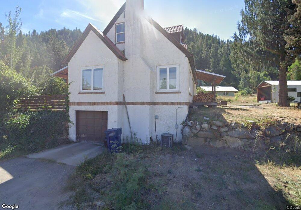
11701 Duncan Rd Leavenworth, WA 98826
Estimated Value: $755,098 - $967,000
3
Beds
2
Baths
1,752
Sq Ft
$503/Sq Ft
Est. Value
About This Home
This home is located at 11701 Duncan Rd, Leavenworth, WA 98826 and is currently estimated at $880,699, approximately $502 per square foot. 11701 Duncan Rd is a home located in Chelan County with nearby schools including Cascade High School and Upper Valley Christian School.
Ownership History
Date
Name
Owned For
Owner Type
Purchase Details
Closed on
Jun 6, 2012
Sold by
Smith Robert S and Smith Anne B
Bought by
Smith Todd A and Smith Julie K
Current Estimated Value
Home Financials for this Owner
Home Financials are based on the most recent Mortgage that was taken out on this home.
Original Mortgage
$180,000
Outstanding Balance
$124,805
Interest Rate
3.84%
Mortgage Type
Seller Take Back
Estimated Equity
$755,894
Purchase Details
Closed on
Jul 19, 2011
Sold by
Duncan Johnson Joyce
Bought by
Smith Robert S and Smith Anne B
Purchase Details
Closed on
Apr 7, 2010
Sold by
Duncan Robert D and Duncan Joanne H
Bought by
Mckerlie John R and Aylesworth Lori K
Purchase Details
Closed on
Apr 6, 2010
Sold by
Johnson Joyce Duncan
Bought by
Mckerlie John R and Aylesworth Lori K
Create a Home Valuation Report for This Property
The Home Valuation Report is an in-depth analysis detailing your home's value as well as a comparison with similar homes in the area
Home Values in the Area
Average Home Value in this Area
Purchase History
| Date | Buyer | Sale Price | Title Company |
|---|---|---|---|
| Smith Todd A | $225,000 | North Meridian Title & Escro | |
| Smith Robert S | $225,000 | North Meridian Title & Escro | |
| Mckerlie John R | -- | North Meridian Title & Escro | |
| Mckerlie John R | $35,000 | North Meridian Title & Escro |
Source: Public Records
Mortgage History
| Date | Status | Borrower | Loan Amount |
|---|---|---|---|
| Open | Smith Todd A | $180,000 |
Source: Public Records
Tax History Compared to Growth
Tax History
| Year | Tax Paid | Tax Assessment Tax Assessment Total Assessment is a certain percentage of the fair market value that is determined by local assessors to be the total taxable value of land and additions on the property. | Land | Improvement |
|---|---|---|---|---|
| 2021 | $5,044 | $521,526 | $152,500 | $369,026 |
| 2020 | $4,092 | $452,897 | $152,500 | $300,397 |
| 2019 | $3,774 | $381,139 | $151,250 | $229,889 |
| 2018 | $3,848 | $341,265 | $128,750 | $212,515 |
| 2017 | $2,694 | $320,210 | $125,000 | $195,210 |
| 2016 | $2,176 | $246,733 | $120,000 | $126,733 |
| 2015 | $2,176 | $255,902 | $115,000 | $140,902 |
| 2013 | $2,176 | $187,099 | $72,000 | $115,099 |
Source: Public Records
Map
Nearby Homes
- 11709 Pear Tree Ct
- 9864 E Leavenworth Rd
- 981 Nighthawk Ridge Ln
- 9696 E Leavenworth Rd
- 9645 E Leavenworth Rd
- 9690 E Leavenworth Rd
- 1313 Front St
- 325 Division St Unit 207
- 1 Chumstick Hwy
- 824 Cedar St
- 1111 Chumstick Hwy
- 2 Cedar St
- 9511 E Leavenworth Rd
- 0 U S Route 2
- 130 Birch St
- 11430 U S Highway 2
- 648 Central Ave
- 315 Commercial St
- 231 Benton St
- 714 Cascade St
- 11749 Pear Tree Ct
- 9780 Mountain Home Rd
- 11769 Pear Tree Ct
- 9761 Mountain Home Rd
- 9799 Mountain Home Rd
- 11719 Pear Tree Ct
- 9791 Mountain Home Rd
- 9725 Mountain Home Rd
- 9768 Mountain Home Rd
- 11750 Pear Tree Ct
- 11770 Pear Tree Ct
- 9846 Mountain Home Rd
- 11720 Pear Tree Ct
- 9767 Mountain Home Rd
- 9787 Mountain Home Rd
- 9791 Hill St
- 11752 D Anjou Ln
- 11772 D Anjou Ln
- 9846 Dye Rd
- 9845 Mountain Home Rd