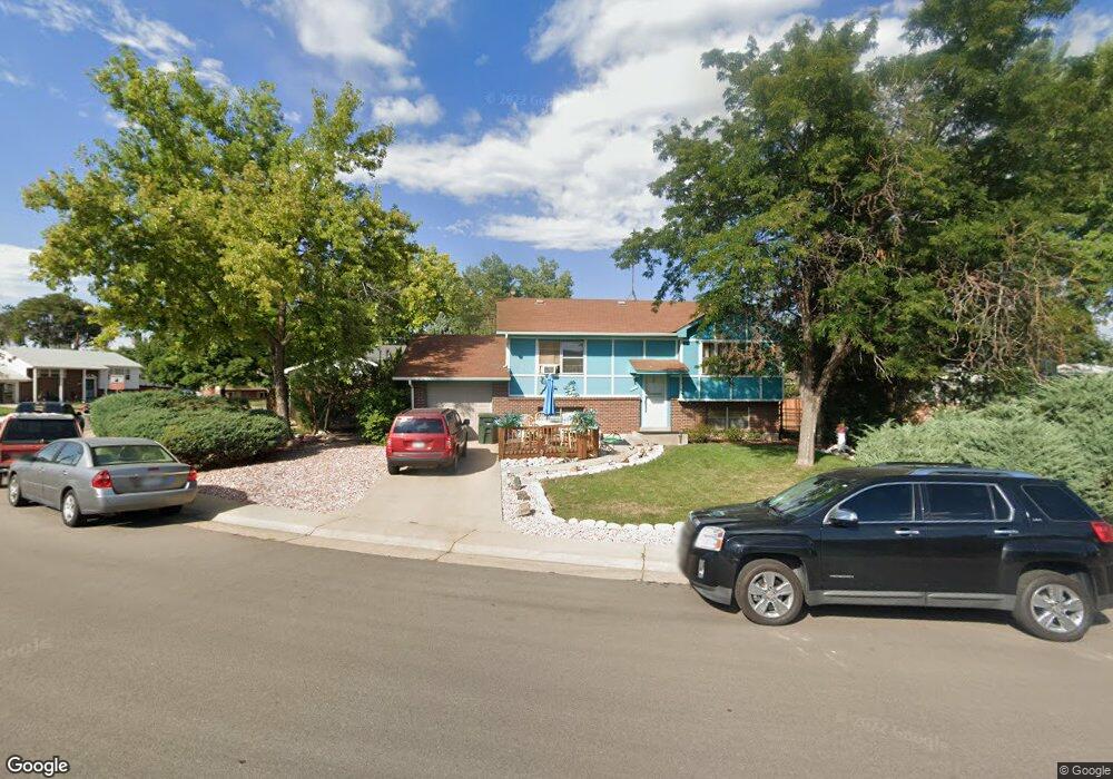
11705 Spring Dr Northglenn, CO 80233
Estimated Value: $441,452 - $500,000
3
Beds
2
Baths
1,834
Sq Ft
$255/Sq Ft
Est. Value
About This Home
This home is located at 11705 Spring Dr, Northglenn, CO 80233 and is currently estimated at $467,113, approximately $254 per square foot. 11705 Spring Dr is a home located in Adams County with nearby schools including Malley Drive Elementary School, Northglenn Middle School, and Mountain Range High School.
Ownership History
Date
Name
Owned For
Owner Type
Purchase Details
Closed on
Nov 12, 1993
Sold by
Lind Jim E and Lind Lori L
Bought by
Aranda Daniel D and Aranda Sherry L
Current Estimated Value
Home Financials for this Owner
Home Financials are based on the most recent Mortgage that was taken out on this home.
Original Mortgage
$87,342
Interest Rate
6.88%
Mortgage Type
FHA
Purchase Details
Closed on
Aug 26, 1991
Create a Home Valuation Report for This Property
The Home Valuation Report is an in-depth analysis detailing your home's value as well as a comparison with similar homes in the area
Home Values in the Area
Average Home Value in this Area
Purchase History
| Date | Buyer | Sale Price | Title Company |
|---|---|---|---|
| Aranda Daniel D | $88,000 | Stewart Title | |
| -- | $73,500 | -- |
Source: Public Records
Mortgage History
| Date | Status | Borrower | Loan Amount |
|---|---|---|---|
| Closed | Aranda Daniel D | $87,342 |
Source: Public Records
Tax History
| Year | Tax Paid | Tax Assessment Tax Assessment Total Assessment is a certain percentage of the fair market value that is determined by local assessors to be the total taxable value of land and additions on the property. | Land | Improvement |
|---|---|---|---|---|
| 2025 | $2,415 | $28,970 | $6,260 | $22,710 |
| 2024 | $2,415 | $26,630 | $5,750 | $20,880 |
| 2023 | $2,393 | $30,710 | $5,610 | $25,100 |
| 2022 | $2,183 | $24,240 | $5,770 | $18,470 |
| 2021 | $2,253 | $24,240 | $5,770 | $18,470 |
| 2020 | $2,103 | $23,610 | $5,930 | $17,680 |
| 2019 | $3,018 | $23,610 | $5,930 | $17,680 |
| 2018 | $2,351 | $17,920 | $5,400 | $12,520 |
| 2017 | $2,163 | $17,920 | $5,400 | $12,520 |
| 2016 | $1,784 | $14,430 | $3,020 | $11,410 |
| 2015 | $1,781 | $14,430 | $3,020 | $11,410 |
| 2014 | $1,540 | $12,160 | $2,390 | $9,770 |
Source: Public Records
Map
Nearby Homes
- 11723 Quam Dr
- 11735 Spring Dr
- 11760 Grant St
- 11748 Grant St
- 11668 Lincoln St
- 424 E 116th Ave
- 404 E 116th Ave
- 11966 Spring Dr
- 11470 Clarkson St
- 11474 Marion St
- 11632 Community Center Dr Unit 53
- 11518 Community Center Dr Unit 20
- 11280 Marion St
- 11258 Larson Ln
- 12142 Bannock Cir Unit B
- 11360 Irma Dr
- 1988 E 116th Ave
- 12237 Creamery St
- 12208 Creamery St
- 12380 Irma Dr
- 11715 Spring Dr
- 11704 Quam Dr
- 11714 Quam Dr
- 11706 Spring Dr
- 11725 Spring Dr
- 11716 Spring Dr
- 11722 Spring Dr
- 11712 Spring Dr
- 11724 Quam Dr
- 11702 Spring Dr
- 11713 Quam Dr
- 11726 Spring Dr
- 11703 Quam Dr
- 11734 Quam Dr
- 11717 Keough Dr
- 11732 Spring Dr
- 11733 Quam Dr
- 11743 Quam Dr
- 11725 Keough Dr
- 11753 Quam Dr
Your Personal Tour Guide
Ask me questions while you tour the home.