Estimated Value: $623,000 - $1,177,510
3
Beds
3
Baths
3,398
Sq Ft
$266/Sq Ft
Est. Value
About This Home
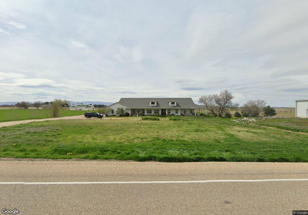
This home is located at 1171 Can Ada Rd, Melba, ID 83641 and is currently estimated at $903,170, approximately $265 per square foot. 1171 Can Ada Rd is a home located in Canyon County with nearby schools including Melba Elementary School and Melba High School.
Ownership History
Date
Name
Owned For
Owner Type
Purchase Details
Closed on
Aug 12, 2021
Sold by
Mortell Michael T and Mortell Patricia A
Bought by
Mortell Michael T and Mortell Patricia A
Current Estimated Value
Purchase Details
Closed on
Apr 20, 2005
Sold by
Bowers Curtis James and Bowers Lauren Mc Alvany
Bought by
Mortell Michael T and Mortell Patricia A
Create a Home Valuation Report for This Property
The Home Valuation Report is an in-depth analysis detailing your home's value as well as a comparison with similar homes in the area
Home Values in the Area
Average Home Value in this Area
Purchase History
| Date | Buyer | Sale Price | Title Company |
|---|---|---|---|
| Mortell Michael T | -- | None Available | |
| Mortell Michael T | -- | Title One |
Source: Public Records
Tax History Compared to Growth
Tax History
| Year | Tax Paid | Tax Assessment Tax Assessment Total Assessment is a certain percentage of the fair market value that is determined by local assessors to be the total taxable value of land and additions on the property. | Land | Improvement |
|---|---|---|---|---|
| 2025 | $2,101 | $960,960 | $161,060 | $799,900 |
| 2024 | $2,101 | $935,880 | $161,780 | $774,100 |
| 2023 | $2,966 | $924,480 | $162,580 | $761,900 |
| 2022 | $3,747 | $942,750 | $172,250 | $770,500 |
| 2021 | $4,739 | $789,050 | $96,350 | $692,700 |
| 2020 | $4,362 | $619,060 | $75,760 | $543,300 |
| 2019 | $4,477 | $602,960 | $66,860 | $536,100 |
| 2018 | $4,343 | $0 | $0 | $0 |
| 2017 | $3,969 | $0 | $0 | $0 |
| 2016 | $3,627 | $0 | $0 | $0 |
| 2015 | $3,435 | $0 | $0 | $0 |
| 2014 | $2,843 | $369,210 | $35,310 | $333,900 |
Source: Public Records
Map
Nearby Homes
- TBD Loomis Ave
- 417 Randolph Dr
- TBD S Southside
- 103 Matthew Ct
- TBD Can Ada
- 6431 Raptor Ridge Ln
- 7978 Base Line Rd
- TBD Parcel 6 Rio Ridge
- TBD Parcel 10 Rio Ridge
- TBD N Melba Rd
- 6900 Yeti Ln
- 408 Hill Rd S
- 3480 Little Foot Ln
- 491 Hill Rd S
- 0 Rose Ln
- 6803 Glendale Rd
- 0 Victory Ln
- 0 Melba Road Map Rock Rd Unit 98960910
- 0 Melba Road Map Rock Rd Unit 98960907
- 8481 Big Foot Rd
- 1091 Can Ada Rd
- TBD Melba Rd and Can Ada Rd
- 1019 Can Ada Rd
- 6068 Melba Rd
- 1019 S Can Ada Rd
- 10700 S Can Ada Rd
- 6258 Melba Rd
- 6289 Melba Rd
- 6305 Melba Rd
- 1587 Can Ada Rd
- 6528 Melba Rd
- 6525 Melba Rd
- 6530 Melba Rd
- 6278 Bonita Ln
- Lot 1 Tbd Bonita Ln
- Lot 1 Tbd Botina Ln
- 10350 Can Ada Rd
- 6201 Bonita Ln
- 10544 S Can Ada Rd
- 6269 Bonita Ln