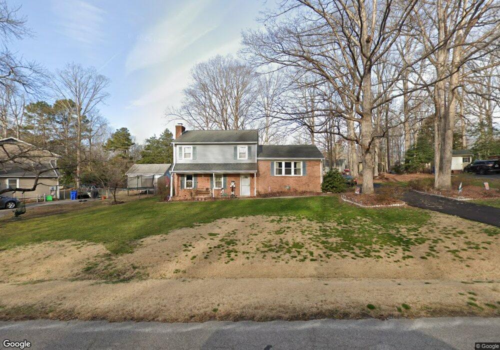
11712 Birdie Ln Chester, VA 23831
Estimated Value: $314,470 - $377,000
3
Beds
2
Baths
1,754
Sq Ft
$196/Sq Ft
Est. Value
About This Home
This home is located at 11712 Birdie Ln, Chester, VA 23831 and is currently estimated at $344,368, approximately $196 per square foot. 11712 Birdie Ln is a home located in Chesterfield County with nearby schools including Ecoff Elementary School, George W. Carver Middle School, and Lloyd C Bird High School.
Ownership History
Date
Name
Owned For
Owner Type
Purchase Details
Closed on
Feb 11, 2002
Bought by
Rusbasan Thomas E and Rusbasan Janice E
Current Estimated Value
Home Financials for this Owner
Home Financials are based on the most recent Mortgage that was taken out on this home.
Original Mortgage
$40,000
Outstanding Balance
$16,621
Interest Rate
7.13%
Mortgage Type
New Conventional
Estimated Equity
$327,747
Create a Home Valuation Report for This Property
The Home Valuation Report is an in-depth analysis detailing your home's value as well as a comparison with similar homes in the area
Home Values in the Area
Average Home Value in this Area
Purchase History
| Date | Buyer | Sale Price | Title Company |
|---|---|---|---|
| Rusbasan Thomas E | -- | -- |
Source: Public Records
Mortgage History
| Date | Status | Borrower | Loan Amount |
|---|---|---|---|
| Open | Rusbasan Thomas E | $40,000 |
Source: Public Records
Tax History Compared to Growth
Tax History
| Year | Tax Paid | Tax Assessment Tax Assessment Total Assessment is a certain percentage of the fair market value that is determined by local assessors to be the total taxable value of land and additions on the property. | Land | Improvement |
|---|---|---|---|---|
| 2025 | $2,345 | $260,700 | $60,000 | $200,700 |
| 2024 | $2,345 | $249,500 | $58,000 | $191,500 |
| 2023 | $2,162 | $237,600 | $58,000 | $179,600 |
| 2022 | $1,863 | $202,500 | $47,000 | $155,500 |
| 2021 | $1,990 | $202,500 | $47,000 | $155,500 |
| 2020 | $1,835 | $193,200 | $45,000 | $148,200 |
| 2019 | $1,630 | $171,600 | $42,000 | $129,600 |
| 2018 | $1,620 | $170,500 | $42,000 | $128,500 |
| 2017 | $1,586 | $165,200 | $42,000 | $123,200 |
| 2016 | $1,586 | $165,200 | $42,000 | $123,200 |
| 2015 | $1,592 | $163,200 | $42,000 | $121,200 |
| 2014 | $1,540 | $157,800 | $42,000 | $115,800 |
Source: Public Records
Map
Nearby Homes
- 4831 Empire Pkwy
- 11325 Vulcan Ln
- 11219 Sparwood Rd
- 5119 Vulcan Ct
- 5001 Stavely Rd
- Millcreek at Womack Green Plan at Womack Green
- Magnolia Plan at Womack Green
- Azalea Ranch Plan at Womack Green
- 5013 Stavely Rd
- 5130 Vulcan Ct
- 5142 Vulcan Ct
- 5019 Stavely Rd
- 11508 Womack Rd
- 4428 Village Garden Cir
- 4401 Village Garden Cir
- 11713 Village Garden Ct
- 5620 Ellingshire Dr Unit 41-4
- 4701 Ecoff Ave
- 11537 Claimont Mill Dr
- 11555 Claimont Mill Dr
- 11706 Birdie Ln
- 4914 Empire Pkwy
- 11718 Birdie Ln
- 4920 Empire Pkwy
- 11713 Birdie Ln
- 4901 Mcallister Dr
- 4907 Mcallister Dr
- 4903 Mcallister Dr
- 11707 Birdie Ln
- 4842 Empire Pkwy
- 4928 Empire Pkwy
- 4913 Empire Pkwy
- 4849 Mcallister Dr
- 0 Birdie Ln
- 4919 Empire Pkwy
- 11800 Birdie Ln
- 4907 Empire Pkwy
- 4936 Empire Pkwy
- 4836 Empire Pkwy
- 4900 Mcallister Dr