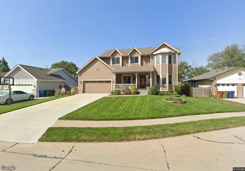
11720 S 27th Cir Bellevue, NE 68123
Estimated Value: $351,000 - $395,000
5
Beds
5
Baths
3,020
Sq Ft
$124/Sq Ft
Est. Value
About This Home
This home is located at 11720 S 27th Cir, Bellevue, NE 68123 and is currently estimated at $373,387, approximately $123 per square foot. 11720 S 27th Cir is a home located in Sarpy County with nearby schools including LeMay Elementary School, Logan Fontenelle Middle School, and Bellevue West High School.
Ownership History
Date
Name
Owned For
Owner Type
Purchase Details
Closed on
May 1, 2025
Sold by
Robinson Edward P and Robinson Ruth E
Bought by
Edward P And Ruth E Robinson Revocable Trust and Robinson
Current Estimated Value
Purchase Details
Closed on
Aug 22, 2000
Sold by
Henry Postel Bruce
Bought by
Robinson Edward P and Robinson Ruth E
Home Financials for this Owner
Home Financials are based on the most recent Mortgage that was taken out on this home.
Original Mortgage
$202,950
Interest Rate
7.99%
Purchase Details
Closed on
Aug 14, 1999
Sold by
Parker Jeany
Bought by
Postel Bruce Henry
Create a Home Valuation Report for This Property
The Home Valuation Report is an in-depth analysis detailing your home's value as well as a comparison with similar homes in the area
Home Values in the Area
Average Home Value in this Area
Purchase History
| Date | Buyer | Sale Price | Title Company |
|---|---|---|---|
| Edward P And Ruth E Robinson Revocable Trust | -- | None Listed On Document | |
| Robinson Edward P | $200,000 | -- | |
| Postel Bruce Henry | -- | -- |
Source: Public Records
Mortgage History
| Date | Status | Borrower | Loan Amount |
|---|---|---|---|
| Previous Owner | Robinson Edward P | $202,950 |
Source: Public Records
Tax History
| Year | Tax Paid | Tax Assessment Tax Assessment Total Assessment is a certain percentage of the fair market value that is determined by local assessors to be the total taxable value of land and additions on the property. | Land | Improvement |
|---|---|---|---|---|
| 2025 | -- | $344,851 | $51,000 | $293,851 |
| 2024 | -- | $333,443 | $51,000 | $282,443 |
| 2023 | -- | $308,564 | $43,000 | $265,564 |
| 2022 | $0 | $291,809 | $38,000 | $253,809 |
| 2021 | $0 | $267,616 | $38,000 | $229,616 |
| 2020 | $4,347 | $261,775 | $38,000 | $223,775 |
| 2019 | $4,347 | $251,811 | $38,000 | $213,811 |
| 2018 | $0 | $248,123 | $29,000 | $219,123 |
| 2017 | $0 | $239,259 | $29,000 | $210,259 |
| 2016 | $4,775 | $229,525 | $29,000 | $200,525 |
| 2015 | $4,347 | $210,164 | $29,000 | $181,164 |
| 2014 | $4,079 | $195,939 | $29,000 | $166,939 |
| 2012 | -- | $192,955 | $29,000 | $163,955 |
Source: Public Records
Map
Nearby Homes
- 2809 Ponderosa Dr
- 3302 E Dutchman Cir
- 3422 Nugget Cir
- 3405 Castile Dr
- 3715 Gayle Ave
- 40.48 Acres
- 12712 S 28th Ave
- 11706 Fisher House Rd
- 2604 Hogantown Dr
- 12806 S 33rd St
- 2804 Greensboro Ave
- 10707 Winding River Dr
- 11814 Quail Dr
- 4210 Barksdale Cir
- 2711 Lynnwood Dr
- 2504 Century Rd
- 4305 Barksdale Dr
- 4212 Longview St
- 12735 S 38th St
- 11406 S 43rd St
- 11722 S 27th Cir
- 11718 S 27th Cir
- 2706 Joann Ave
- 2705 Alpine Cir
- 11716 S 27th Cir
- 2612 Joann Ave
- 2707 Alpine Cir
- 11714 S 27th Cir
- 2708 Joann Ave
- 2704 Alpine Cir
- 2705 Joann Ave
- 2703 Joann Ave
- 11716 S 26th Ave
- 2701 Joann Ave
- 11714 S 26th Ave
- 2707 Joann Ave
- 2610 Joann Ave
- 11717 S 27th St
- 2613 Joann Ave
- 11712 S 26th Ave
Your Personal Tour Guide
Ask me questions while you tour the home.