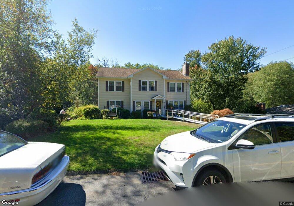
1173 Amostown Rd West Springfield, MA 01089
Estimated Value: $433,194 - $491,000
4
Beds
2
Baths
2,685
Sq Ft
$171/Sq Ft
Est. Value
About This Home
This home is located at 1173 Amostown Rd, West Springfield, MA 01089 and is currently estimated at $459,549, approximately $171 per square foot. 1173 Amostown Rd is a home located in Hampden County with nearby schools including Hampden Charter School of Science West and St Thomas The Apostle School.
Ownership History
Date
Name
Owned For
Owner Type
Purchase Details
Closed on
Jan 31, 1996
Sold by
Fnma
Bought by
Mitchell Mark H and Mitchell Melanie J
Current Estimated Value
Purchase Details
Closed on
Jul 28, 1995
Sold by
Eisenbeiser John H
Bought by
Federal National Mortgage Association
Purchase Details
Closed on
Dec 13, 1990
Sold by
Lussier Mark D
Bought by
Eisenbeiser John H
Purchase Details
Closed on
Oct 31, 1988
Sold by
Stine Steven H
Bought by
Lussier Mark D
Create a Home Valuation Report for This Property
The Home Valuation Report is an in-depth analysis detailing your home's value as well as a comparison with similar homes in the area
Home Values in the Area
Average Home Value in this Area
Purchase History
| Date | Buyer | Sale Price | Title Company |
|---|---|---|---|
| Mitchell Mark H | $110,000 | -- | |
| Federal National Mortgage Association | $115,600 | -- | |
| Eisenbeiser John H | $135,000 | -- | |
| Lussier Mark D | $144,000 | -- |
Source: Public Records
Mortgage History
| Date | Status | Borrower | Loan Amount |
|---|---|---|---|
| Open | Lussier Mark D | $73,000 | |
| Closed | Lussier Mark D | $40,000 |
Source: Public Records
Tax History Compared to Growth
Tax History
| Year | Tax Paid | Tax Assessment Tax Assessment Total Assessment is a certain percentage of the fair market value that is determined by local assessors to be the total taxable value of land and additions on the property. | Land | Improvement |
|---|---|---|---|---|
| 2025 | $5,126 | $344,700 | $102,400 | $242,300 |
| 2024 | $5,047 | $340,800 | $102,400 | $238,400 |
| 2023 | $4,732 | $304,500 | $102,400 | $202,100 |
| 2022 | $4,262 | $270,400 | $93,100 | $177,300 |
| 2021 | $4,323 | $255,800 | $87,800 | $168,000 |
| 2020 | $4,346 | $255,800 | $87,800 | $168,000 |
| 2019 | $4,338 | $255,800 | $87,800 | $168,000 |
| 2018 | $4,361 | $255,800 | $87,800 | $168,000 |
| 2017 | $4,361 | $255,800 | $87,800 | $168,000 |
| 2016 | $4,329 | $254,800 | $84,400 | $170,400 |
| 2015 | $4,244 | $249,800 | $82,700 | $167,100 |
| 2014 | $1,031 | $249,800 | $82,700 | $167,100 |
Source: Public Records
Map
Nearby Homes
- 34 High Meadow Dr
- 43 Wishing Well Way
- 283 Forest Glen
- 86 Birnie Ave
- 42 Gregory Ln
- 31 Stone Path Ln
- 514 Dewey St
- 260 Wolcott Ave
- 81 Laurence Dr
- 36 Shady Brook
- 64 Apple Ridge Rd
- 61 Clarence St
- 16 North St
- 65 Verdugo St
- 180 Wolcott Ave
- 7 Brewster Rd
- 142 Morton St
- 32 Lotus Ave
- 139 Upper Beverly Hills
- 19 Cora St
- 1181 Amostown Rd
- 1161 Amostown Rd
- 1151 Amostown Rd
- 1172 Amostown Rd
- 1180 Amostown Rd
- 1193 Amostown Rd
- 1198 Amostown Rd
- 1156 Amostown Rd
- 1141 Amostown Rd
- 177 Sawmill Rd
- 187 Sawmill Rd
- 1209 Amostown Rd
- 1210 Amostown Rd
- 1127 Amostown Rd
- 199 Sawmill Rd
- 1132 Amostown Rd
- 1218 Amostown Rd
- 1190 Amostown Rd
- 188 Sawmill Rd
- 1192 Amostown Rd