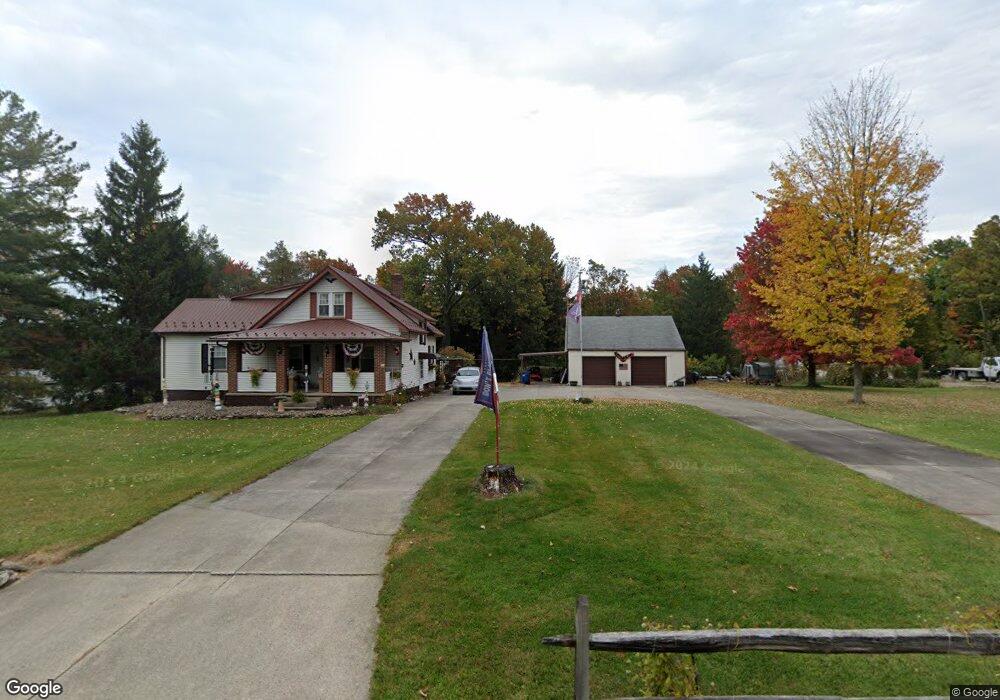
11743 Clarke Rd Columbia Station, OH 44028
Estimated Value: $145,000 - $425,000
3
Beds
2
Baths
1,552
Sq Ft
$185/Sq Ft
Est. Value
About This Home
This home is located at 11743 Clarke Rd, Columbia Station, OH 44028 and is currently estimated at $287,277, approximately $185 per square foot. 11743 Clarke Rd is a home located in Lorain County with nearby schools including Strongsville High School and Sts Joseph & John Interparochial School.
Ownership History
Date
Name
Owned For
Owner Type
Purchase Details
Closed on
Aug 31, 2004
Sold by
Greener Patrick H and Greener Rosanne
Bought by
Greener Patrick G and Greener Rosanne
Current Estimated Value
Home Financials for this Owner
Home Financials are based on the most recent Mortgage that was taken out on this home.
Original Mortgage
$92,000
Outstanding Balance
$45,470
Interest Rate
5.95%
Mortgage Type
New Conventional
Estimated Equity
$241,807
Purchase Details
Closed on
Jun 6, 1996
Sold by
Lake Walter J
Bought by
Greener Patrick H and Greener Rosanne
Home Financials for this Owner
Home Financials are based on the most recent Mortgage that was taken out on this home.
Original Mortgage
$98,600
Interest Rate
7.97%
Mortgage Type
New Conventional
Create a Home Valuation Report for This Property
The Home Valuation Report is an in-depth analysis detailing your home's value as well as a comparison with similar homes in the area
Home Values in the Area
Average Home Value in this Area
Purchase History
| Date | Buyer | Sale Price | Title Company |
|---|---|---|---|
| Greener Patrick G | -- | -- | |
| Greener Patrick H | $116,000 | -- |
Source: Public Records
Mortgage History
| Date | Status | Borrower | Loan Amount |
|---|---|---|---|
| Open | Greener Patrick G | $92,000 | |
| Closed | Greener Patrick H | $98,600 |
Source: Public Records
Tax History Compared to Growth
Tax History
| Year | Tax Paid | Tax Assessment Tax Assessment Total Assessment is a certain percentage of the fair market value that is determined by local assessors to be the total taxable value of land and additions on the property. | Land | Improvement |
|---|---|---|---|---|
| 2024 | $2,289 | $54,453 | $23,534 | $30,919 |
| 2023 | $2,809 | $50,516 | $22,047 | $28,469 |
| 2022 | $2,709 | $50,516 | $22,047 | $28,469 |
| 2021 | $2,723 | $50,516 | $22,047 | $28,469 |
| 2020 | $2,813 | $46,220 | $20,170 | $26,050 |
| 2019 | $2,793 | $46,220 | $20,170 | $26,050 |
| 2018 | $2,511 | $46,220 | $20,170 | $26,050 |
| 2017 | $2,498 | $42,550 | $18,690 | $23,860 |
| 2016 | $2,513 | $42,550 | $18,690 | $23,860 |
| 2015 | $2,522 | $42,550 | $18,690 | $23,860 |
| 2014 | $2,498 | $42,550 | $18,690 | $23,860 |
| 2013 | $2,496 | $42,550 | $18,690 | $23,860 |
Source: Public Records
Map
Nearby Homes
- 23686 Wally's Way
- 11055 David's Ct
- 23567 Victory Ln
- 11030 Southwind Ct
- 23688 Rebecca Ln
- 10800 Meadow Trail
- 23755 Rebecca Ln
- 23769 Wally's Way
- 23465 Kim's Trail
- 23409 Kim's Trail
- 23446 Kim's Trail
- 23789 Snell Rd
- 23863 Heatherstone Trail
- 10001 N Marks Rd
- 12150 N Boone Rd
- 21648 Oak Bark Trail
- 21359 Briar Bush Ln
- 9989 Plum Brook Ln
- 1078 Greenhouse Trail
- 9829 Plum Brook Ln
- 11509 Reserve Way
- 11517 Reserve Way
- 11525 Reserve Way
- 11501 Reserve Way
- 11731 Clarke Rd
- 11731 Clarke Rd
- 11533 Reserve Way
- 11493 Reserve Way
- 11541 Reserve Way
- 11669 Clarke Rd
- 11837 Clarke Rd
- 11485 Reserve Way
- 11520 Reserve Way
- 11500 Reserve Way
- 11549 Reserve Way
- 11859 Clarke Rd
- 11528 Reserve Way
- 11476 Reserve Way
- 11536 Reserve Way
- 11477 Reserve Way