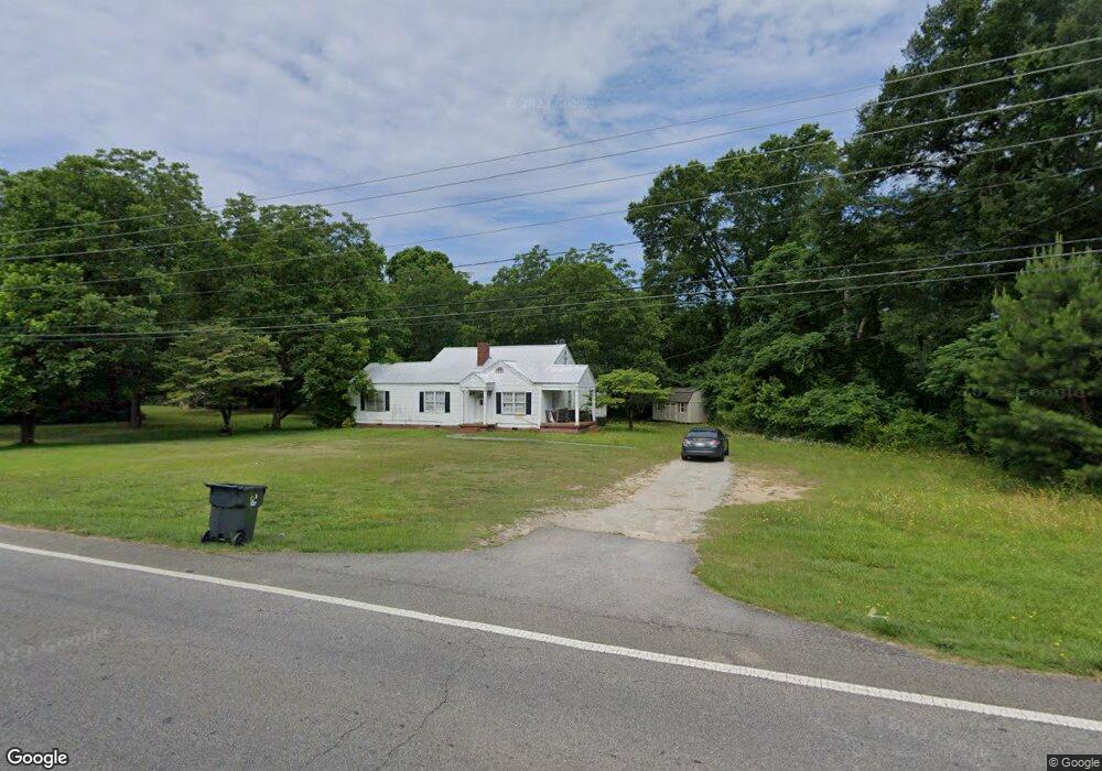
1175 N Cherokee Rd Social Circle, GA 30025
Estimated Value: $173,000 - $348,000
--
Bed
--
Bath
1,632
Sq Ft
$157/Sq Ft
Est. Value
About This Home
This home is located at 1175 N Cherokee Rd, Social Circle, GA 30025 and is currently estimated at $257,002, approximately $157 per square foot. 1175 N Cherokee Rd is a home located in Walton County with nearby schools including Social Circle Primary School, Social Circle Elementary School, and Social Circle Middle School.
Ownership History
Date
Name
Owned For
Owner Type
Purchase Details
Closed on
Jan 10, 2019
Sold by
Fortson Kyle B
Bought by
Mitchell Timothy R and Mitchell Paige W
Current Estimated Value
Purchase Details
Closed on
Jan 18, 2002
Sold by
Kilgore Allen G
Bought by
Fortson Kyle B
Home Financials for this Owner
Home Financials are based on the most recent Mortgage that was taken out on this home.
Original Mortgage
$7,500
Interest Rate
6.85%
Mortgage Type
New Conventional
Create a Home Valuation Report for This Property
The Home Valuation Report is an in-depth analysis detailing your home's value as well as a comparison with similar homes in the area
Home Values in the Area
Average Home Value in this Area
Purchase History
| Date | Buyer | Sale Price | Title Company |
|---|---|---|---|
| Mitchell Timothy R | $85,000 | -- | |
| Fortson Kyle B | -- | -- |
Source: Public Records
Mortgage History
| Date | Status | Borrower | Loan Amount |
|---|---|---|---|
| Previous Owner | Fortson Kyle B | $7,500 |
Source: Public Records
Tax History Compared to Growth
Tax History
| Year | Tax Paid | Tax Assessment Tax Assessment Total Assessment is a certain percentage of the fair market value that is determined by local assessors to be the total taxable value of land and additions on the property. | Land | Improvement |
|---|---|---|---|---|
| 2024 | $2,187 | $61,480 | $18,400 | $43,080 |
| 2023 | $599 | $57,560 | $16,560 | $41,000 |
| 2022 | $529 | $50,800 | $14,720 | $36,080 |
| 2021 | $442 | $42,480 | $10,120 | $32,360 |
| 2020 | $363 | $39,800 | $7,800 | $32,000 |
| 2019 | $357 | $32,120 | $7,800 | $24,320 |
| 2018 | $350 | $32,120 | $7,800 | $24,320 |
| 2017 | $1,172 | $28,040 | $5,960 | $22,080 |
| 2016 | $292 | $25,800 | $5,960 | $19,840 |
| 2015 | $257 | $22,840 | $5,960 | $16,880 |
| 2014 | $244 | $20,560 | $5,960 | $14,600 |
Source: Public Records
Map
Nearby Homes
- 1302 N Cherokee Rd
- 684 N Cherokee Rd
- 1526 N Cherokee Rd
- 690 Park Place Way
- 695 Park Place Way
- 670 Park Place Way
- 960 Park Place St
- 741 Jackson Ct
- 931 Park Place St
- 939 Park Place St
- 1244 Morrow Dr
- 310 Crossroads Dr
- 815 Crossroads Ct
- 821 Crossroads Ct
- 843 Crossroads Ct
- 853 Crossroads Ct
- 228 Oak Dr NE
- 381 Crossroads Dr
- 413 Crossroads Dr
- 443 Windsong Ln
- 1155 N Cherokee Rd
- 1166 N Cherokee Rd
- 1180 N Cherokee Rd
- 1172 N Cherokee Rd
- 1192 N Cherokee Rd
- 1200 N Cherokee Rd
- 1210 N Cherokee Rd
- 1148 N Cherokee Rd
- 1148 N Cherokee Rd
- 1134 N Cherokee Rd
- 0 Malcom Unit 5973423
- 0 Malcom Unit 7607334
- 0 Malcom Unit 8144385
- 0 Malcom Unit 7024321
- 0 Malcom Unit 20029869
- 0 Malcom Unit 8551156
- 1122 N Cherokee Rd
- 500 Meadows Ln
- 1262 N Cherokee Rd
- 503 Meadows Ln