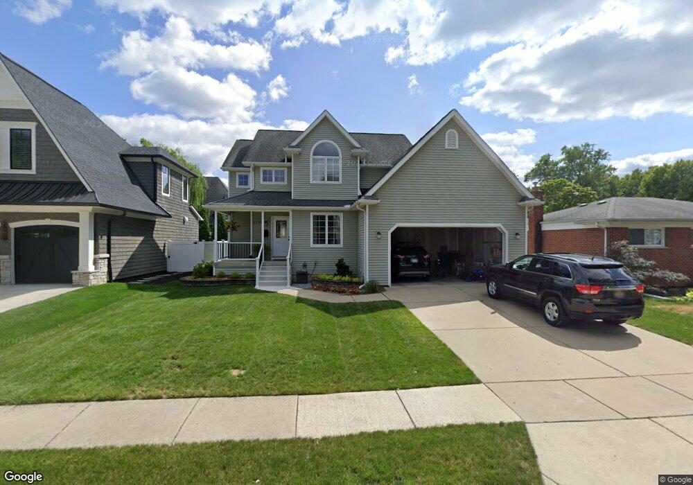
1175 Sutherland St Plymouth, MI 48170
Estimated Value: $548,000 - $725,000
3
Beds
3
Baths
2,078
Sq Ft
$306/Sq Ft
Est. Value
About This Home
This home is located at 1175 Sutherland St, Plymouth, MI 48170 and is currently estimated at $636,503, approximately $306 per square foot. 1175 Sutherland St is a home located in Wayne County with nearby schools including Canton High School, Smith Elementary School, and West Middle School.
Ownership History
Date
Name
Owned For
Owner Type
Purchase Details
Closed on
Nov 15, 2007
Sold by
Tellier Robert B and Evans Margaret A
Bought by
Toth Mark J
Current Estimated Value
Home Financials for this Owner
Home Financials are based on the most recent Mortgage that was taken out on this home.
Original Mortgage
$220,000
Outstanding Balance
$139,841
Interest Rate
6.47%
Mortgage Type
Purchase Money Mortgage
Estimated Equity
$496,662
Purchase Details
Closed on
Oct 10, 2007
Sold by
Evans Margaret A and Tellier Robert B
Bought by
Lasalle Bank Na
Home Financials for this Owner
Home Financials are based on the most recent Mortgage that was taken out on this home.
Original Mortgage
$220,000
Outstanding Balance
$139,841
Interest Rate
6.47%
Mortgage Type
Purchase Money Mortgage
Estimated Equity
$496,662
Purchase Details
Closed on
Apr 15, 2002
Sold by
Parsons George C
Bought by
Evans Margaret A
Create a Home Valuation Report for This Property
The Home Valuation Report is an in-depth analysis detailing your home's value as well as a comparison with similar homes in the area
Home Values in the Area
Average Home Value in this Area
Purchase History
| Date | Buyer | Sale Price | Title Company |
|---|---|---|---|
| Toth Mark J | $275,000 | Fidelity National Title | |
| Lasalle Bank Na | $179,676 | None Available | |
| Evans Margaret A | $95,000 | -- |
Source: Public Records
Mortgage History
| Date | Status | Borrower | Loan Amount |
|---|---|---|---|
| Open | Toth Mark J | $220,000 |
Source: Public Records
Tax History Compared to Growth
Tax History
| Year | Tax Paid | Tax Assessment Tax Assessment Total Assessment is a certain percentage of the fair market value that is determined by local assessors to be the total taxable value of land and additions on the property. | Land | Improvement |
|---|---|---|---|---|
| 2025 | $6,342 | $317,300 | $0 | $0 |
| 2024 | $6,342 | $288,000 | $0 | $0 |
| 2023 | $6,177 | $256,100 | $0 | $0 |
| 2022 | $6,548 | $240,900 | $0 | $0 |
| 2021 | $6,345 | $237,500 | $0 | $0 |
| 2020 | $6,328 | $230,500 | $0 | $0 |
| 2019 | $5,571 | $225,300 | $0 | $0 |
| 2018 | $5,411 | $216,700 | $0 | $0 |
| 2017 | $1,146 | $217,900 | $0 | $0 |
| 2016 | $5,895 | $206,500 | $0 | $0 |
| 2015 | $13,502 | $160,030 | $0 | $0 |
| 2013 | $13,081 | $140,080 | $0 | $0 |
| 2011 | -- | $125,120 | $0 | $0 |
Source: Public Records
Map
Nearby Homes
- 1125 Sutherland St
- 844 Ross St
- 1338 S Harvey St
- 638 S Harvey St
- 1199 S Sheldon Rd Unit 77
- 553 Jener Place
- 775 Deer Ct Unit 104
- 685 Ross St
- 44571 Clare Blvd
- 801 W Ann Arbor Trail Unit 306
- 543 Deer St
- 684 Harding St
- 9453 Brookline Ave
- 9405 Northern Ave
- 660 Maple St
- 668 Maple St
- 636 Maple St
- 644 Maple St
- 44736 Lynn Dr
- 628 Maple St
- 1191 Sutherland St
- 1151 Sutherland St
- 1184 Palmer St
- 1174 Palmer St Unit Bldg-Unit
- 1174 Palmer St
- 1200 Palmer St
- 1184 Sutherland St
- 1133 Sutherland St
- 1168 Sutherland St
- 1150 Palmer St
- 1154 Sutherland St Unit Bldg-Unit
- 1154 Sutherland St
- 1201 Palmer St
- 1201 Carol Ave
- 1220 Palmer St
- 1134 Sutherland St
- 1128 Palmer St
- 1221 Palmer St
- 1122 Sutherland St
- 1217 Carol Ave