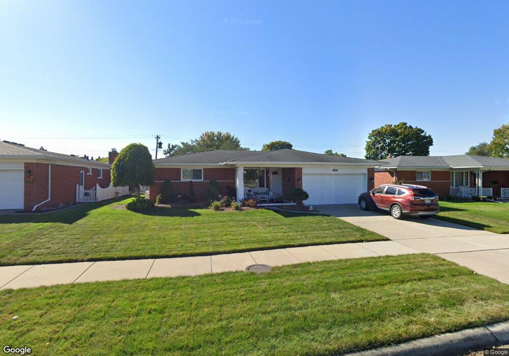
11750 Robinwood Blvd Warren, MI 48093
Northeast Warren NeighborhoodEstimated Value: $289,000 - $302,000
--
Bed
2
Baths
1,603
Sq Ft
$184/Sq Ft
Est. Value
About This Home
This home is located at 11750 Robinwood Blvd, Warren, MI 48093 and is currently estimated at $294,972, approximately $184 per square foot. 11750 Robinwood Blvd is a home located in Macomb County with nearby schools including Wilkerson Elementary School, Carter Middle School, and Paul K. Cousino High School.
Ownership History
Date
Name
Owned For
Owner Type
Purchase Details
Closed on
Apr 19, 2024
Sold by
Weaver Robert and Weaver Robert
Bought by
Weaver Robert D
Current Estimated Value
Home Financials for this Owner
Home Financials are based on the most recent Mortgage that was taken out on this home.
Original Mortgage
$236,800
Outstanding Balance
$233,167
Interest Rate
6.74%
Mortgage Type
New Conventional
Estimated Equity
$61,805
Create a Home Valuation Report for This Property
The Home Valuation Report is an in-depth analysis detailing your home's value as well as a comparison with similar homes in the area
Home Values in the Area
Average Home Value in this Area
Purchase History
| Date | Buyer | Sale Price | Title Company |
|---|---|---|---|
| Weaver Robert D | $296,000 | None Listed On Document | |
| Weaver Robert D | $296,000 | None Listed On Document |
Source: Public Records
Mortgage History
| Date | Status | Borrower | Loan Amount |
|---|---|---|---|
| Open | Weaver Robert D | $236,800 | |
| Closed | Weaver Robert D | $236,800 |
Source: Public Records
Tax History Compared to Growth
Tax History
| Year | Tax Paid | Tax Assessment Tax Assessment Total Assessment is a certain percentage of the fair market value that is determined by local assessors to be the total taxable value of land and additions on the property. | Land | Improvement |
|---|---|---|---|---|
| 2025 | $3,531 | $135,090 | $0 | $0 |
| 2024 | $3,431 | $121,030 | $0 | $0 |
| 2023 | $3,253 | $109,680 | $0 | $0 |
| 2022 | $3,143 | $95,820 | $0 | $0 |
| 2021 | $3,198 | $88,290 | $0 | $0 |
| 2020 | $3,083 | $82,300 | $0 | $0 |
| 2019 | $2,973 | $79,050 | $0 | $0 |
| 2018 | $85 | $75,280 | $0 | $0 |
| 2017 | $2,981 | $66,940 | $10,460 | $56,480 |
| 2016 | $2,978 | $66,940 | $0 | $0 |
| 2015 | -- | $54,750 | $0 | $0 |
| 2012 | -- | $52,460 | $0 | $0 |
Source: Public Records
Map
Nearby Homes
- 30329 Blancke Dr
- 11616 Lynch Ct
- 29819 Bonnie Dr
- 30154 Pinto Dr
- 30218 Palomino Dr
- 29723 Roan Dr
- 31057 Hoover Rd Unit 8
- 12490 E 13 Mile Rd
- 29820 Palomino Dr
- 11720 Canterbury Dr
- 30419 Iroquois Dr
- 29654 Hoover Rd Unit 129
- 11562 Helen Dr
- 29638 Hoover Rd Unit 638
- 29626 Hoover Rd Unit 626
- 31036 Palomino Ave
- 11377 Irene Ave
- 29366 Wagner Dr
- 30590 Campbell St
- 31310 Pinto Dr
- 11738 Robinwood Blvd
- 11816 Robinwood Blvd
- 11733 Aleta Cir
- 11721 Aleta Cir
- 11726 Robinwood Blvd
- 11745 Aleta Cir
- 11709 Aleta Cir
- 11811 Aleta Cir
- 11815 Robinwood Blvd
- 11733 Robinwood Blvd
- 11714 Robinwood Blvd
- 11840 Robinwood Blvd
- 11827 Robinwood Blvd
- 11655 Aleta Cir
- 11721 Robinwood Blvd
- 11823 Aleta Cir
- 11839 Robinwood Blvd
- 11654 Robinwood Blvd
- 30316 Mcgrath Dr
- 30315 Mcgrath Dr