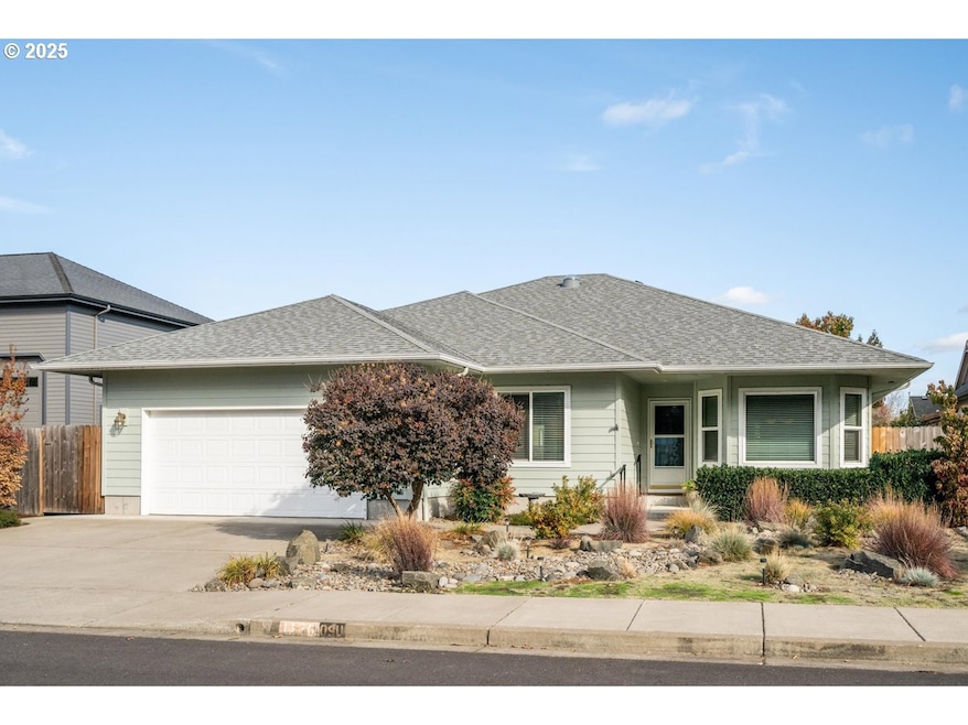
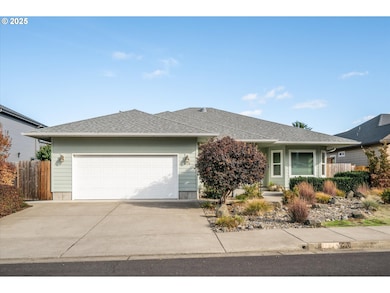
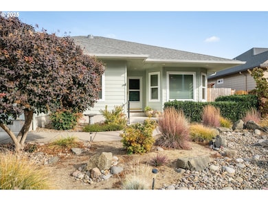
1176 Unity Dr Junction City, OR 97448
Estimated payment $2,973/month
Highlights
- Custom Home
- Wood Flooring
- No HOA
- View of Trees or Woods
- Private Yard
- Covered Patio or Porch
About This Home
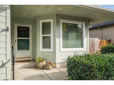
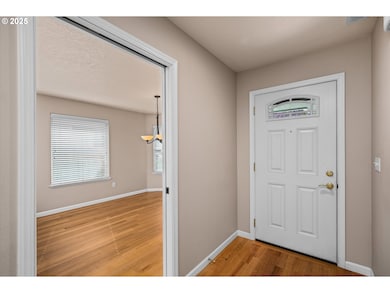
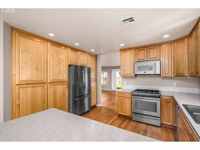
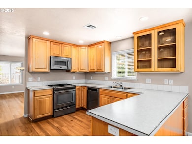
Immaculate Custom One-Level Home, First Time on the Market. Built by local builder Larry Vannortwick, this one-owner home offers exceptional craftsmanship, and a wonderful functional layout. The large kitchen features gorgeous Alder cabinetry by Davis Cabinets of Junction City, stainless steel appliances including a gas cooktop. built-in microwave, tons of storage, and a free-standing refrigerator included. An inviting eating area off the kitchen framed by a beautiful bay window. Quarter-sawn red oak floors, high ceilings and recessed lighting throughout. The large formal dining room and inviting living room with a gas fireplace with remote control. The large primary suite features a walk-in closet with a window, dual vanity with marble countertops, a walk-in shower with marble surround, and a slider to the back patio. Wide hallways and doorways make this home easily accessible. Two additional bedrooms include extra outlets and cable. The main bathroom features marble countertops and an extra-deep bathtub. Indoor utility room with sink and cabinets. Large, fenced backyard with custom Solara covered patio with remote-controlled opening panels, a gas BBQ hookup, and hot tub with cover and proper drainage. Whole-house carbon water filtration system. 2 attached finished garage with storage above. Christmas light outlet under the eaves with the control in the garage for easy holiday décor. Handicap-friendly design. Around the corner from Oak Meadows Park. This home has been meticulously cared for; you can feel the quality the moment you walk in.
Listing Agent
Berkshire Hathaway HomeServices Real Estate Professionals Brokerage Phone: 541-485-1400 License #200308139 Listed on: 10/24/2025

Co-Listing Agent
Berkshire Hathaway HomeServices Real Estate Professionals Brokerage Phone: 541-485-1400 License #791000004
Home Details
Home Type
- Single Family
Est. Annual Taxes
- $4,525
Year Built
- Built in 2011
Lot Details
- 7,405 Sq Ft Lot
- Fenced
- Level Lot
- Sprinkler System
- Landscaped with Trees
- Private Yard
- Garden
Parking
- 2 Car Attached Garage
- Garage on Main Level
- Driveway
Home Design
- Custom Home
- Composition Roof
- Cement Siding
Interior Spaces
- 1,927 Sq Ft Home
- 1-Story Property
- Built-In Features
- Recessed Lighting
- Gas Fireplace
- Natural Light
- Double Pane Windows
- Vinyl Clad Windows
- Entryway
- Family Room
- Living Room
- Dining Room
- First Floor Utility Room
- Laundry Room
- Utility Room
- Wood Flooring
- Views of Woods
- Crawl Space
Kitchen
- Eat-In Kitchen
- Built-In Range
- Microwave
- Dishwasher
- Disposal
Bedrooms and Bathrooms
- 3 Bedrooms
- 2 Full Bathrooms
- Built-In Bathroom Cabinets
- Solar Tube
Accessible Home Design
- Accessible Hallway
- Accessibility Features
- Accessible Doors
- Level Entry For Accessibility
Outdoor Features
- Covered Patio or Porch
Schools
- Laurel Elementary School
- Oaklea Middle School
- Junction City High School
Utilities
- Cooling Available
- Forced Air Heating System
- Heating System Uses Gas
- Heat Pump System
- Electric Water Heater
- High Speed Internet
Community Details
- No Home Owners Association
Listing and Financial Details
- Assessor Parcel Number 1843091
Map
Home Values in the Area
Average Home Value in this Area
Tax History
| Year | Tax Paid | Tax Assessment Tax Assessment Total Assessment is a certain percentage of the fair market value that is determined by local assessors to be the total taxable value of land and additions on the property. | Land | Improvement |
|---|---|---|---|---|
| 2025 | $4,689 | $273,519 | -- | -- |
| 2024 | $4,525 | $265,553 | -- | -- |
| 2023 | $4,525 | $257,819 | $0 | $0 |
| 2022 | $4,222 | $250,310 | $0 | $0 |
| 2021 | $4,137 | $243,020 | $0 | $0 |
| 2020 | $4,005 | $235,942 | $0 | $0 |
| 2019 | $3,864 | $229,070 | $0 | $0 |
| 2018 | $3,753 | $215,921 | $0 | $0 |
| 2017 | $3,621 | $215,921 | $0 | $0 |
| 2016 | $3,521 | $209,632 | $0 | $0 |
| 2015 | $3,117 | $203,526 | $0 | $0 |
| 2014 | $3,128 | $197,598 | $0 | $0 |
Property History
| Date | Event | Price | List to Sale | Price per Sq Ft |
|---|---|---|---|---|
| 01/13/2026 01/13/26 | Price Changed | $500,000 | -9.1% | $259 / Sq Ft |
| 10/24/2025 10/24/25 | For Sale | $550,000 | -- | $285 / Sq Ft |
Purchase History
| Date | Type | Sale Price | Title Company |
|---|---|---|---|
| Interfamily Deed Transfer | -- | First American | |
| Interfamily Deed Transfer | -- | First American Title | |
| Interfamily Deed Transfer | -- | None Available | |
| Warranty Deed | $70,000 | Cascade Title Company |
Mortgage History
| Date | Status | Loan Amount | Loan Type |
|---|---|---|---|
| Open | $220,500 | New Conventional |
Source: Regional Multiple Listing Service (RMLS)
MLS Number: 761552022
APN: 1843091
Disclaimer: Certain information contained herein is derived from information provided by parties other than Homes.com. All information provided is deemed reliable, but is not guaranteed to be accurate and should be independently verified.
![]() The content relating to real estate for sale on this web site comes in part from the IDX program of the RMLS™ of Portland, Oregon. Real estate listings held by brokerage firms other than Ten-X are marked with the RMLS™ logo, and detailed information about these properties includes the names of the listing brokers. Listing content is copyright © 2025 RMLS™, Portland, Oregon. Some properties which appear for sale on this web site may subsequently have sold or may no longer be available. All information provided is deemed reliable but is not guaranteed and should be independently verified.
The content relating to real estate for sale on this web site comes in part from the IDX program of the RMLS™ of Portland, Oregon. Real estate listings held by brokerage firms other than Ten-X are marked with the RMLS™ logo, and detailed information about these properties includes the names of the listing brokers. Listing content is copyright © 2025 RMLS™, Portland, Oregon. Some properties which appear for sale on this web site may subsequently have sold or may no longer be available. All information provided is deemed reliable but is not guaranteed and should be independently verified.
- 1011 Rose St
- 2213 W 10th Ave
- 2249 W 10th Ave
- 2269 W 10th Ave
- 2289 W 10th Ave
- 1225 W 10th Ave Unit 18
- 1225 W 10th Ave Unit 50
- 1225 W 10th Ave
- 1225 W 10th Ave Unit 53
- 2313 W 10th Ave
- 1036 Oak St
- 970 W 10th Ave
- 2347 W 10th Ave
- 2363 W 10th Ave
- 2331 W 10th Ave
- 2379 W 10th Ave
- 887 Darlington Dr
- 920 W 10th Ave
- 1090 Nyssa St
- The 1783 Plan at Rolling Meadows
- 2272 W 10th Ave
- 955 W 17th Ave
- 4075 Aerial Way
- 910 Westsprings Dr
- 1367 Umpqua Ave
- 1440 John Day Dr
- 3610 Goodpasture Loop
- 3950 Goodpasture Loop
- 1220 Jacobs Dr
- 777 St Charles St
- 2050 Goodpasture Loop
- 721 Throne Dr
- 4300 Goodpasture Loop
- 2863 Applewood Ln
- 1150 Darlene Ln
- 655 Goodpasture Island Rd
- 1884 Happy Ln
- 470 Alexander Loop
- 435 Alexander Loop
- 3335 Coburg Rd