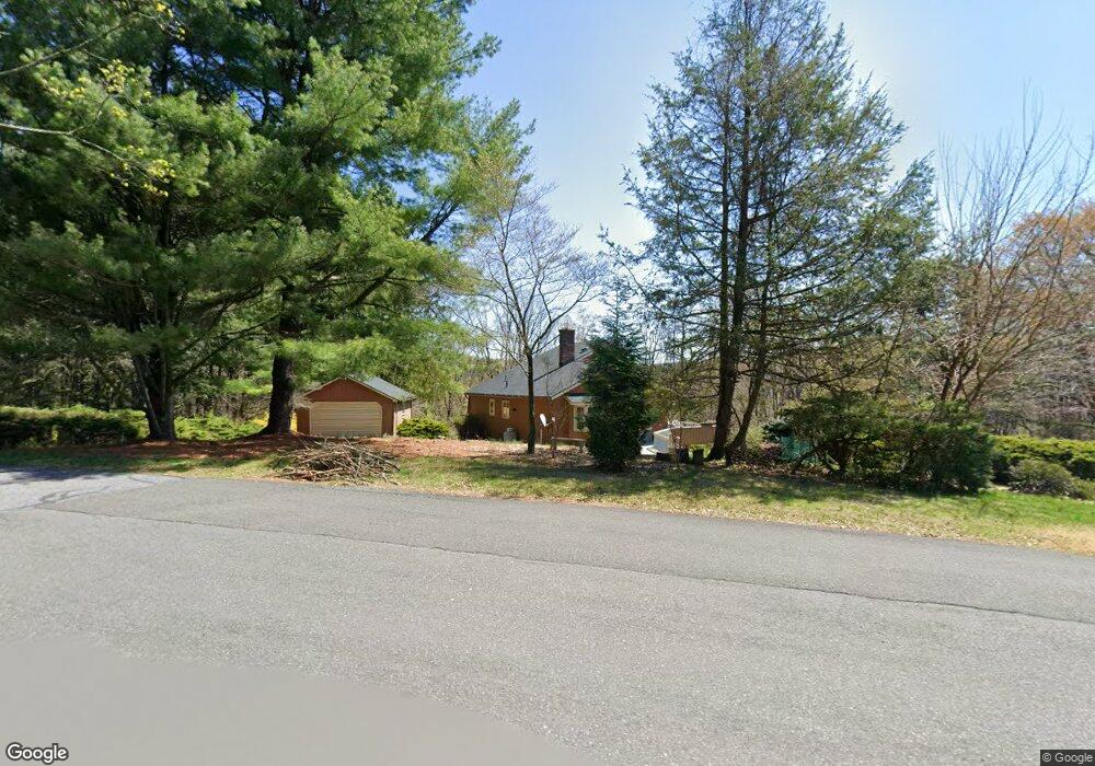
118 Antietam Trace Reading, PA 19606
Estimated Value: $368,000 - $395,000
3
Beds
2
Baths
1,544
Sq Ft
$247/Sq Ft
Est. Value
About This Home
This home is located at 118 Antietam Trace, Reading, PA 19606 and is currently estimated at $380,922, approximately $246 per square foot. 118 Antietam Trace is a home located in Berks County with nearby schools including Mt Penn Primary Center, Mount Penn Primary Center, and Mount Penn Elementary Center.
Ownership History
Date
Name
Owned For
Owner Type
Purchase Details
Closed on
Feb 28, 2007
Sold by
Voigt Wilhelm H and Voigt Christia K
Bought by
Townsend Debra D
Current Estimated Value
Home Financials for this Owner
Home Financials are based on the most recent Mortgage that was taken out on this home.
Original Mortgage
$40,000
Interest Rate
6.12%
Mortgage Type
Stand Alone Second
Create a Home Valuation Report for This Property
The Home Valuation Report is an in-depth analysis detailing your home's value as well as a comparison with similar homes in the area
Home Values in the Area
Average Home Value in this Area
Purchase History
| Date | Buyer | Sale Price | Title Company |
|---|---|---|---|
| Townsend Debra D | $240,000 | None Available |
Source: Public Records
Mortgage History
| Date | Status | Borrower | Loan Amount |
|---|---|---|---|
| Closed | Townsend Debra D | $40,000 | |
| Open | Townsend Debra D | $160,000 |
Source: Public Records
Tax History Compared to Growth
Tax History
| Year | Tax Paid | Tax Assessment Tax Assessment Total Assessment is a certain percentage of the fair market value that is determined by local assessors to be the total taxable value of land and additions on the property. | Land | Improvement |
|---|---|---|---|---|
| 2025 | $2,984 | $145,100 | $49,800 | $95,300 |
| 2024 | $9,432 | $145,100 | $49,800 | $95,300 |
| 2023 | $9,115 | $145,100 | $49,800 | $95,300 |
| 2022 | $8,826 | $145,100 | $49,800 | $95,300 |
| 2021 | $8,640 | $145,100 | $49,800 | $95,300 |
| 2020 | $8,401 | $145,100 | $49,800 | $95,300 |
| 2019 | $8,137 | $145,100 | $49,800 | $95,300 |
| 2018 | $8,051 | $145,100 | $49,800 | $95,300 |
| 2017 | $7,812 | $145,100 | $49,800 | $95,300 |
| 2016 | $2,179 | $145,100 | $49,800 | $95,300 |
| 2015 | $2,179 | $145,100 | $49,800 | $95,300 |
| 2014 | $2,069 | $145,100 | $49,800 | $95,300 |
Source: Public Records
Map
Nearby Homes
- 1717 Friedensburg Rd
- 1440 Friedensburg Rd
- 41 Aldine Ave
- 174 Taft Ave
- 1519 Friedensburg Rd
- 1280 Fox Run
- 1261 Fox Run
- 1125 Deer Run
- 923 Carsonia Ave
- 1020 Sterling Ave
- 1034 Butter Ln
- 20 Overlook Dr
- 240 Spies Church Rd Unit 216
- 115 Mayer St
- 2509 Park St
- 222 Opal Ave
- 9 Wyndham Hill Dr
- 2571 Hill Rd
- 606 Brighton Ave
- 2615 Antietam Ave
- 120 Antietam Trace
- 104 Antietam Trace
- 116 Antietam Trace
- 19 Lewis Rd
- 17 Lewis Rd
- 108 Antietam Trace
- 100 Antietam Trace
- 26 Lewis Rd
- 106 Antietam Trace
- 181 Lewis Rd
- 1727 Friedensburg Rd
- 28 Lewis Rd
- 15 Lewis Rd
- 1722 Friedensburg Rd
- 1726 Friedensburg Rd
- 1720 Friedensburg Rd
- 1728 Friedensburg Rd
- 1712 Friedensburg Rd
- 34 Lewis Rd
- 114 Antietam Trace