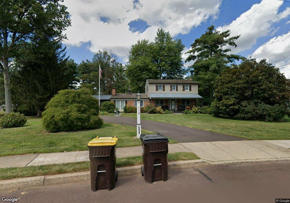
118 Bates Dr Chalfont, PA 18914
Estimated Value: $587,000 - $643,000
--
Bed
3
Baths
2,214
Sq Ft
$278/Sq Ft
Est. Value
About This Home
This home is located at 118 Bates Dr, Chalfont, PA 18914 and is currently estimated at $616,306, approximately $278 per square foot. 118 Bates Dr is a home located in Bucks County with nearby schools including Simon Butler Elementary, Unami Middle School, and Central Bucks High School - South.
Ownership History
Date
Name
Owned For
Owner Type
Purchase Details
Closed on
Jan 28, 2021
Sold by
Tracy Kelley M and Estate Of William David Myers
Bought by
Cusate Anthony and Cusate Nicole
Current Estimated Value
Home Financials for this Owner
Home Financials are based on the most recent Mortgage that was taken out on this home.
Original Mortgage
$449,100
Outstanding Balance
$401,462
Interest Rate
2.67%
Mortgage Type
New Conventional
Estimated Equity
$214,844
Purchase Details
Closed on
Jul 27, 1971
Bought by
Myres Wm David and Myres Alexandra T
Create a Home Valuation Report for This Property
The Home Valuation Report is an in-depth analysis detailing your home's value as well as a comparison with similar homes in the area
Home Values in the Area
Average Home Value in this Area
Purchase History
| Date | Buyer | Sale Price | Title Company |
|---|---|---|---|
| Cusate Anthony | $499,000 | Professional Group Abstract | |
| Myres Wm David | -- | -- |
Source: Public Records
Mortgage History
| Date | Status | Borrower | Loan Amount |
|---|---|---|---|
| Open | Cusate Anthony | $449,100 |
Source: Public Records
Tax History Compared to Growth
Tax History
| Year | Tax Paid | Tax Assessment Tax Assessment Total Assessment is a certain percentage of the fair market value that is determined by local assessors to be the total taxable value of land and additions on the property. | Land | Improvement |
|---|---|---|---|---|
| 2025 | $5,269 | $30,400 | $6,200 | $24,200 |
| 2024 | $5,269 | $30,400 | $6,200 | $24,200 |
| 2023 | $5,101 | $30,400 | $6,200 | $24,200 |
| 2022 | $5,000 | $30,400 | $6,200 | $24,200 |
| 2021 | $4,943 | $30,400 | $6,200 | $24,200 |
| 2020 | $4,943 | $30,400 | $6,200 | $24,200 |
| 2019 | $4,883 | $30,400 | $6,200 | $24,200 |
| 2018 | $4,883 | $30,400 | $6,200 | $24,200 |
| 2017 | $4,845 | $30,400 | $6,200 | $24,200 |
| 2016 | $4,845 | $30,400 | $6,200 | $24,200 |
| 2015 | -- | $30,400 | $6,200 | $24,200 |
| 2014 | -- | $30,400 | $6,200 | $24,200 |
Source: Public Records
Map
Nearby Homes
- 200 Cornwall Dr
- 0 S Limekiln Pike
- 10 Kerns Ave
- 40 E Butler Ave
- 722 Upper State Rd
- The Brentwood Plan at Barclay Hill
- The Banbury Plan at Barclay Hill
- The Brookhaven Plan at Barclay Hill
- 129 Cambridge Place
- 136 Tartan Terrace
- 103 Bonnie Lark Ct
- 14 Woodside Ave
- 26 Park Ave Unit A16
- 201 Coventry Rd
- 116 Tartan Terrace
- 202 Shepard Ln
- 214 Prince William Way
- 241 Coventry Rd
- 113 Hamilton St
- 300 Brookside Ct
- 116 Bates Dr
- 120 Bates Dr
- 121 Bates Dr
- 206 New Jersey Ave
- 122 Bates Dr
- 210 New Jersey Ave
- 122 S Taft Ave
- 202 New Jersey Ave
- 218 New Jersey Ave
- 123 Bates Dr
- 164 New Jersey Ave
- 124 S Taft Ave
- 101 North Ln
- 124 Bates Dr
- 222 New Jersey Ave
- 125 Bates Dr
- 119 Hampshire Dr
- 160 New Jersey Ave
- 117 Hampshire Dr
- 126 S Taft Ave