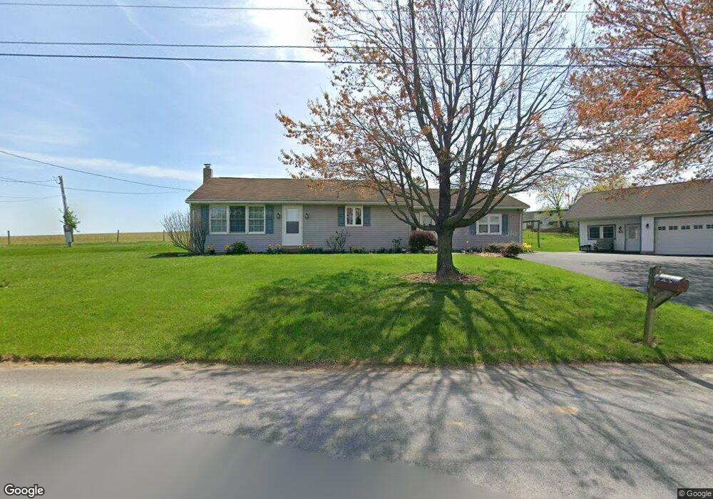
118 Brendle Rd East Earl, PA 17519
Estimated Value: $313,727 - $390,000
2
Beds
1
Bath
1,440
Sq Ft
$247/Sq Ft
Est. Value
About This Home
This home is located at 118 Brendle Rd, East Earl, PA 17519 and is currently estimated at $355,682, approximately $247 per square foot. 118 Brendle Rd is a home located in Lancaster County with nearby schools including Garden Spot Middle School, Garden Spot Senior High School, and Spring Grove School.
Ownership History
Date
Name
Owned For
Owner Type
Purchase Details
Closed on
Sep 25, 2008
Sold by
Martin William D and Martin Tracy L
Bought by
Brubaker Eva
Current Estimated Value
Purchase Details
Closed on
Mar 11, 2003
Sold by
Martin William D and Martin Tracy L
Bought by
Martin William D and Martin Tracy L
Home Financials for this Owner
Home Financials are based on the most recent Mortgage that was taken out on this home.
Original Mortgage
$68,500
Interest Rate
5.91%
Purchase Details
Closed on
Oct 7, 2002
Sold by
Martin William D
Bought by
Martin William D
Create a Home Valuation Report for This Property
The Home Valuation Report is an in-depth analysis detailing your home's value as well as a comparison with similar homes in the area
Home Values in the Area
Average Home Value in this Area
Purchase History
| Date | Buyer | Sale Price | Title Company |
|---|---|---|---|
| Brubaker Eva | $210,000 | None Available | |
| Martin William D | -- | -- | |
| Martin William D | -- | -- |
Source: Public Records
Mortgage History
| Date | Status | Borrower | Loan Amount |
|---|---|---|---|
| Previous Owner | Martin William D | $68,500 |
Source: Public Records
Tax History Compared to Growth
Tax History
| Year | Tax Paid | Tax Assessment Tax Assessment Total Assessment is a certain percentage of the fair market value that is determined by local assessors to be the total taxable value of land and additions on the property. | Land | Improvement |
|---|---|---|---|---|
| 2025 | $2,849 | $159,100 | $46,700 | $112,400 |
| 2024 | $2,849 | $159,100 | $46,700 | $112,400 |
| 2023 | $2,808 | $159,100 | $46,700 | $112,400 |
| 2022 | $2,778 | $159,100 | $46,700 | $112,400 |
| 2021 | $2,734 | $159,100 | $46,700 | $112,400 |
| 2020 | $2,734 | $159,100 | $46,700 | $112,400 |
| 2019 | $2,704 | $159,100 | $46,700 | $112,400 |
| 2018 | $3,813 | $159,100 | $46,700 | $112,400 |
| 2017 | $2,689 | $129,100 | $27,500 | $101,600 |
| 2016 | $2,689 | $129,100 | $27,500 | $101,600 |
| 2015 | $747 | $129,100 | $27,500 | $101,600 |
| 2014 | $1,796 | $129,100 | $27,500 | $101,600 |
Source: Public Records
Map
Nearby Homes
- 2085 Main St
- 1487 Ironstone Dr
- 1411 Martin St
- 1276 Martin St
- 2140 Main St
- 1220 Shetland Cir
- 1215 Shetland Cir
- 5907 Wertztown Rd
- 1022 Elwood St
- 1923 Barnett St
- 1328 Union Grove Rd
- 1145 Brownstone Ridge
- 302 E Main St
- 5884 Mast Rd
- 103 Lynwood Dr
- 412 Linden St
- 671 Gault Rd
- 0 Laurel Rd
- 2287 Laurel Rd
- 420 Linden St
- 119 Brendle Rd
- 1651 Main St
- 0 Wolf Cir Unit 1004690793
- 0 Wolf Cir Unit 1004690727
- 0 Wolf Cir Unit 142258
- 0 Wolf Cir Unit 142255
- 1653 Main St
- 1649 Main St
- 1655 Main St
- 1653 Main St
- 1647 Main St
- 1657 Main St
- 1659 Main St
- 1661 Main St
- 1660 Main St
- 1665 Main St
- 1629 Main St
- 104 Bridgeville Rd
- 1673 Main St
- 1625 Main St