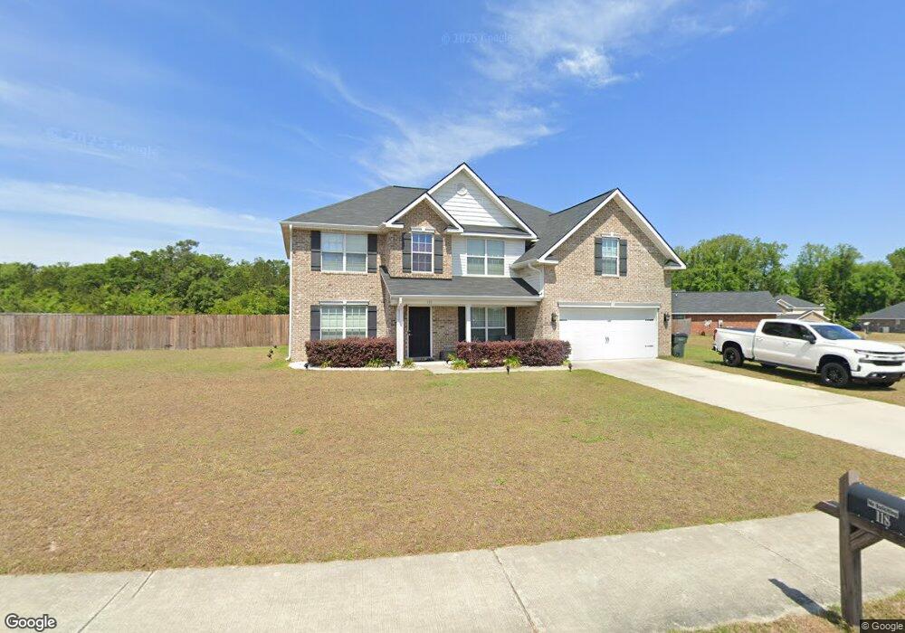
118 Broad Lead Rd Allenhurst, GA 31301
Estimated Value: $317,120 - $337,000
3
Beds
3
Baths
2,879
Sq Ft
$113/Sq Ft
Est. Value
About This Home
This home is located at 118 Broad Lead Rd, Allenhurst, GA 31301 and is currently estimated at $325,780, approximately $113 per square foot. 118 Broad Lead Rd is a home located in Liberty County with nearby schools including Frank Long Elementary School, Lewis Frasier Middle School, and Liberty County High School.
Ownership History
Date
Name
Owned For
Owner Type
Purchase Details
Closed on
Jun 17, 2025
Sold by
Dryden Enterprise Inc
Bought by
Baxter Breanna J and Baxter Geoffery Miller
Current Estimated Value
Purchase Details
Closed on
Apr 18, 2024
Sold by
Baptiste-Auld Edgar
Bought by
Streb Peter
Home Financials for this Owner
Home Financials are based on the most recent Mortgage that was taken out on this home.
Original Mortgage
$316,562
Interest Rate
6.87%
Mortgage Type
New Conventional
Purchase Details
Closed on
Nov 13, 2014
Sold by
Dryden Enterprises Inc
Bought by
Baptiste Auld Edgar
Home Financials for this Owner
Home Financials are based on the most recent Mortgage that was taken out on this home.
Original Mortgage
$221,665
Interest Rate
4%
Mortgage Type
VA
Purchase Details
Closed on
Aug 30, 2013
Sold by
Dryden Claude L and Dryden Loretta R
Bought by
Dryden Enterprises Inc
Create a Home Valuation Report for This Property
The Home Valuation Report is an in-depth analysis detailing your home's value as well as a comparison with similar homes in the area
Home Values in the Area
Average Home Value in this Area
Purchase History
| Date | Buyer | Sale Price | Title Company |
|---|---|---|---|
| Baxter Breanna J | $323,900 | -- | |
| Streb Peter | $309,900 | -- | |
| Baptiste Auld Edgar | $217,000 | -- | |
| Dryden Enterprises Inc | -- | -- |
Source: Public Records
Mortgage History
| Date | Status | Borrower | Loan Amount |
|---|---|---|---|
| Previous Owner | Streb Peter | $316,562 | |
| Previous Owner | Baptiste Auld Edgar | $221,665 |
Source: Public Records
Tax History Compared to Growth
Tax History
| Year | Tax Paid | Tax Assessment Tax Assessment Total Assessment is a certain percentage of the fair market value that is determined by local assessors to be the total taxable value of land and additions on the property. | Land | Improvement |
|---|---|---|---|---|
| 2024 | $16 | $122,301 | $16,000 | $106,301 |
| 2023 | $16 | $109,775 | $16,000 | $93,775 |
| 2022 | $15 | $91,307 | $16,000 | $75,307 |
| 2021 | $15 | $83,058 | $16,000 | $67,058 |
| 2020 | $15 | $83,751 | $16,000 | $67,751 |
| 2019 | $15 | $81,184 | $16,000 | $65,184 |
| 2018 | $43 | $81,843 | $16,000 | $65,843 |
| 2017 | $3,665 | $86,389 | $16,000 | $70,389 |
| 2016 | $2,976 | $85,908 | $12,000 | $73,908 |
| 2015 | $209 | $85,908 | $12,000 | $73,908 |
| 2014 | $209 | $6,000 | $6,000 | $0 |
Source: Public Records
Map
Nearby Homes
- 40 Red Blossom Ct
- 128 Nashview Trail
- 1801 Dunlevie Rd
- 50 Harold's Nook
- 1600 Dunlevie Rd Unit 16
- 1600 Dunlevie Rd Unit 50
- 151 Hunters Branch Dr
- 169 Wellspring Terrace
- 1343 Talmadge Rd
- 996 Dunlevie Rd
- 304 Thompson Rd
- 29 Douglas Rd
- 194 Mccumber Dr
- 744 Dunlevie Rd
- 480 Mccumber Dr
- 166 Stephanie Dr
- 619 Mccumber Dr
- 801 Talmadge Rd
- 118 Broad Leaf Rd
- 162 Broad Leaf Rd
- 109 Broad Leaf Rd
- 94 Broad Leaf Rd
- 121 Broad Leaf Rd
- 118 Broad Leaf Rd
- 38 Broad Leaf Rd
- 109 Broad Leaf Rd
- 57 Broad Leaf Trail
- 153 Broad Leaf Rd
- 941 Broad Leaf Rd
- 139 Broad Leaf Rd
- 87 Broad Leaf Rd
- 74 Broad Leaf Rd Unit n/a
- 74 Broad Leaf Rd
- 188 Broad Leaf Rd
- 13 Nashview Trail
- 609 Nashview Trail
- 56 Broad Leaf Rd
- 60 Red Blossom Ct