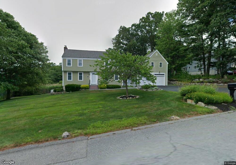
118 Cranberry Rd Dracut, MA 01826
Estimated Value: $692,000 - $798,000
3
Beds
2
Baths
2,004
Sq Ft
$367/Sq Ft
Est. Value
About This Home
This home is located at 118 Cranberry Rd, Dracut, MA 01826 and is currently estimated at $736,429, approximately $367 per square foot. 118 Cranberry Rd is a home located in Middlesex County with nearby schools including Joseph A. Campbell Elementary School, Richardson Middle School, and Dracut Senior High School.
Ownership History
Date
Name
Owned For
Owner Type
Purchase Details
Closed on
May 11, 2021
Sold by
Bourassa David C and Bourassa Brenda M
Bought by
Bourassa Ft
Current Estimated Value
Purchase Details
Closed on
Dec 15, 1987
Sold by
Difonzo Frank S
Bought by
Mancini Margaret A
Purchase Details
Closed on
Apr 11, 1986
Bought by
Bourassa David C and Bourassa Brenda M
Create a Home Valuation Report for This Property
The Home Valuation Report is an in-depth analysis detailing your home's value as well as a comparison with similar homes in the area
Home Values in the Area
Average Home Value in this Area
Purchase History
| Date | Buyer | Sale Price | Title Company |
|---|---|---|---|
| Bourassa Ft | -- | None Available | |
| Mancini Margaret A | $259,900 | -- | |
| Bourassa David C | $151,000 | -- |
Source: Public Records
Mortgage History
| Date | Status | Borrower | Loan Amount |
|---|---|---|---|
| Previous Owner | Bourassa David C | $240,000 | |
| Previous Owner | Bourassa David C | $50,000 | |
| Previous Owner | Bourassa David C | $115,000 |
Source: Public Records
Tax History
| Year | Tax Paid | Tax Assessment Tax Assessment Total Assessment is a certain percentage of the fair market value that is determined by local assessors to be the total taxable value of land and additions on the property. | Land | Improvement |
|---|---|---|---|---|
| 2025 | $6,762 | $668,200 | $242,800 | $425,400 |
| 2024 | $6,591 | $630,700 | $231,400 | $399,300 |
| 2023 | $6,382 | $551,100 | $201,400 | $349,700 |
| 2022 | $6,143 | $499,800 | $183,200 | $316,600 |
| 2021 | $6,060 | $465,800 | $166,300 | $299,500 |
| 2020 | $5,857 | $438,700 | $161,300 | $277,400 |
| 2019 | $5,591 | $406,600 | $153,600 | $253,000 |
| 2018 | $5,592 | $395,500 | $153,600 | $241,900 |
| 2017 | $5,542 | $395,500 | $153,600 | $241,900 |
| 2016 | $5,564 | $374,900 | $154,400 | $220,500 |
| 2015 | -- | $359,000 | $154,400 | $204,600 |
| 2014 | $4,956 | $342,000 | $154,400 | $187,600 |
Source: Public Records
Map
Nearby Homes
- 277 Loon Hill Rd
- 84 Tellier Way
- 935 Methuen St Unit 13
- 30 Parker Rd
- 10 Lanseigne St
- 144 Thissell Ave Unit 11
- 315 Broadway Rd Unit 1
- 315 Broadway Rd Unit 7
- 11 Joseph Ave
- 4 Hazelwood Ave Unit 12
- 89 Newbury St
- 287 Fox Ave
- 668 Robbins Ave Unit 1
- 785 Broadway Rd
- 700 Robbins Ave Unit 6
- 31 Varnum Ave
- 194 River Rd
- 20 Mount Pleasant St
- 69 Arlington St
- 40 Arlington Ave
- 14 Trout Brook Rd
- 119 Cranberry Rd
- 24 Trout Brook Rd
- 109 Cranberry Rd
- 108 Cranberry Rd
- 140 Cranberry Rd
- 139 Cranberry Rd
- 139 Cranberry Rd Unit 139
- 34 Trout Brook Rd
- 17 Trout Brook Rd
- 27 Trout Brook Rd
- 92 Cranberry Rd
- 44 Trout Brook Rd
- 35 Trout Brook Rd
- 149 Cranberry Rd
- 82 Cranberry Rd
- 93 Cranberry Rd
- 15 Mulberry Rd
- 44 Chestnut Rd
- 54 Trout Brook Rd
Your Personal Tour Guide
Ask me questions while you tour the home.