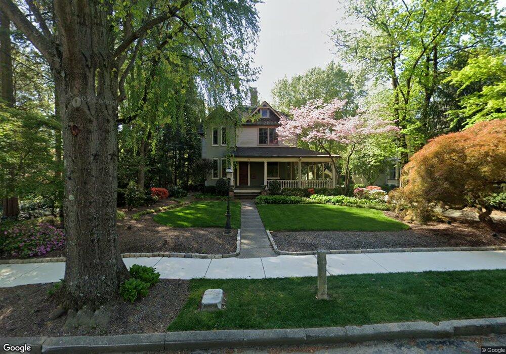
118 E Maple Ave Moorestown, NJ 08057
Estimated Value: $825,664 - $1,087,000
Studio
--
Bath
2,937
Sq Ft
$326/Sq Ft
Est. Value
About This Home
This home is located at 118 E Maple Ave, Moorestown, NJ 08057 and is currently estimated at $956,916, approximately $325 per square foot. 118 E Maple Ave is a home located in Burlington County with nearby schools including George C. Baker Elementary School, Moorestown Upper Elementary School, and William Allen Middle School.
Ownership History
Date
Name
Owned For
Owner Type
Purchase Details
Closed on
Sep 14, 2005
Sold by
Hoffman Catherine
Bought by
Hoffman David
Current Estimated Value
Home Financials for this Owner
Home Financials are based on the most recent Mortgage that was taken out on this home.
Original Mortgage
$89,000
Outstanding Balance
$47,406
Interest Rate
5.78%
Mortgage Type
Fannie Mae Freddie Mac
Estimated Equity
$909,510
Purchase Details
Closed on
Apr 14, 2004
Sold by
Hoffman Jennifer L
Bought by
Hoffman David
Create a Home Valuation Report for This Property
The Home Valuation Report is an in-depth analysis detailing your home's value as well as a comparison with similar homes in the area
Home Values in the Area
Average Home Value in this Area
Purchase History
| Date | Buyer | Sale Price | Title Company |
|---|---|---|---|
| Hoffman David | -- | Surety Title Corp | |
| Hoffman David | -- | -- |
Source: Public Records
Mortgage History
| Date | Status | Borrower | Loan Amount |
|---|---|---|---|
| Open | Hoffman David | $89,000 |
Source: Public Records
Tax History
| Year | Tax Paid | Tax Assessment Tax Assessment Total Assessment is a certain percentage of the fair market value that is determined by local assessors to be the total taxable value of land and additions on the property. | Land | Improvement |
|---|---|---|---|---|
| 2025 | $12,415 | $437,600 | $198,700 | $238,900 |
| 2024 | $12,038 | $437,600 | $198,700 | $238,900 |
| 2023 | $12,038 | $437,600 | $198,700 | $238,900 |
| 2022 | $11,916 | $437,600 | $198,700 | $238,900 |
| 2021 | $11,758 | $437,600 | $198,700 | $238,900 |
| 2020 | $11,684 | $437,600 | $198,700 | $238,900 |
| 2019 | $11,478 | $437,600 | $198,700 | $238,900 |
| 2018 | $11,168 | $437,600 | $198,700 | $238,900 |
| 2017 | $11,264 | $437,600 | $198,700 | $238,900 |
| 2016 | $11,224 | $437,600 | $198,700 | $238,900 |
| 2015 | $11,089 | $437,600 | $198,700 | $238,900 |
| 2014 | $10,529 | $437,600 | $198,700 | $238,900 |
Source: Public Records
Map
Nearby Homes
- 205 E Central Ave
- 133 Plum St Unit 6
- 80 E 3rd St
- 66 E 3rd St
- 308 Elm St
- 700 Lippincott Ave
- 127 Schooley St
- 408 N Stanwick Rd
- 228 Mill St
- 863 Golf View Rd
- 104 Mount Laurel Rd
- 325 E 2nd St
- 744 Signal Light Rd
- 337 E 2nd St
- 437 Windrow Clusters Dr
- 543 Bethel Ave
- 451 E 2nd St
- 15 W Close Unit 15
- 22 E Close Unit 22
- 8 S Close Unit 8
- 116 E Maple Ave
- 126 E Maple Ave
- 125 E Oak Ave
- 129 E Oak Ave
- 121 E Oak Ave
- 130 E Maple Ave
- 133 E Oak Ave
- 119 E Maple Ave
- 119 E Oak Ave
- 123 E Maple Ave
- 117 E Maple Ave
- 137 E Oak Ave
- 117 E Oak Ave
- 125 E Maple Ave
- 515 Chester Ave
- 517 Chester Ave
- 134 E Maple Ave
- 520 Chestnut St
- 601 Chester Ave
- 509 Chester Ave
Your Personal Tour Guide
Ask me questions while you tour the home.