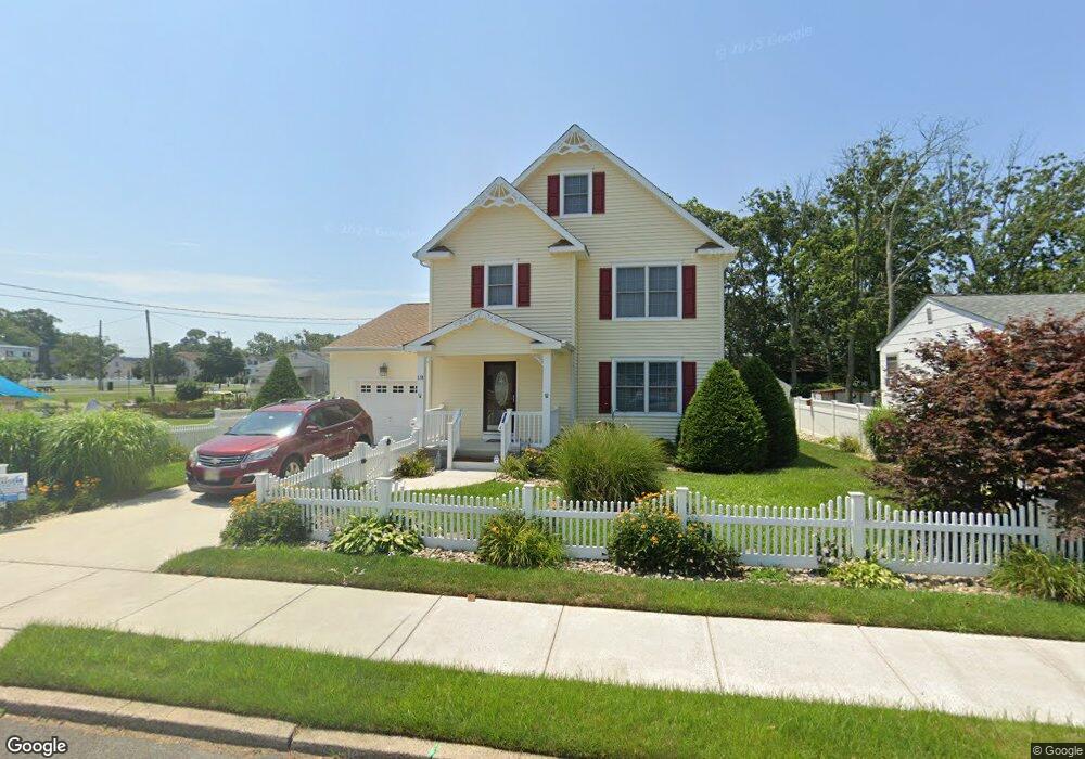
118 W Groveland Ave Somers Point, NJ 08244
Estimated Value: $543,290 - $720,000
--
Bed
--
Bath
2,795
Sq Ft
$233/Sq Ft
Est. Value
About This Home
This home is located at 118 W Groveland Ave, Somers Point, NJ 08244 and is currently estimated at $650,573, approximately $232 per square foot. 118 W Groveland Ave is a home located in Atlantic County with nearby schools including Mainland Regional High School, ChARTer TECH High School for the Performing Arts, and Saint Joseph Regional School.
Ownership History
Date
Name
Owned For
Owner Type
Purchase Details
Closed on
Jul 29, 2024
Sold by
Miller Kathryn Ak and Miller Michael L
Bought by
Miller Michael L
Current Estimated Value
Purchase Details
Closed on
Dec 14, 2007
Sold by
Sammartino Ralph J and Sammartino Joanne
Bought by
Miller Kathryn A K and Miller Michael L
Purchase Details
Closed on
Feb 23, 2007
Sold by
Martin Joseph
Bought by
Sammartino Ralph and Sammartino Joanne
Create a Home Valuation Report for This Property
The Home Valuation Report is an in-depth analysis detailing your home's value as well as a comparison with similar homes in the area
Home Values in the Area
Average Home Value in this Area
Purchase History
| Date | Buyer | Sale Price | Title Company |
|---|---|---|---|
| Miller Michael L | -- | None Listed On Document | |
| Miller Kathryn A K | $344,275 | None Available | |
| Sammartino Ralph | $135,000 | -- |
Source: Public Records
Tax History Compared to Growth
Tax History
| Year | Tax Paid | Tax Assessment Tax Assessment Total Assessment is a certain percentage of the fair market value that is determined by local assessors to be the total taxable value of land and additions on the property. | Land | Improvement |
|---|---|---|---|---|
| 2025 | $10,413 | $291,200 | $67,600 | $223,600 |
| 2024 | $10,413 | $291,200 | $67,600 | $223,600 |
| 2023 | $9,729 | $291,200 | $67,600 | $223,600 |
| 2022 | $9,729 | $291,200 | $67,600 | $223,600 |
| 2021 | $9,583 | $291,200 | $67,600 | $223,600 |
| 2020 | $9,388 | $291,200 | $67,600 | $223,600 |
| 2019 | $9,123 | $291,200 | $67,600 | $223,600 |
| 2018 | $8,931 | $291,200 | $67,600 | $223,600 |
| 2017 | $9,184 | $310,600 | $67,600 | $243,000 |
| 2016 | $8,768 | $310,600 | $67,600 | $243,000 |
| 2015 | $8,678 | $310,600 | $67,600 | $243,000 |
| 2014 | $8,386 | $310,600 | $67,600 | $243,000 |
Source: Public Records
Map
Nearby Homes
- 421 Shore Rd
- 1102 Jesse Dr
- 2102 Angelina Ln
- 25 W Pierson Ave
- 109 E Cedar Ave
- 101 E Johnson Ave
- 1020 Pleasant Ave
- 1013 Pleasant Ave
- 1014 Pleasant Ave
- 1024 Pleasant Ave
- 1015 Pleasant Ave
- 29 E Pierson Ave
- 123 E Cedar Ave
- 303 Garden Terrace
- 112 E Pierson Ave
- 114 E Pierson Ave
- 33 W Meyran Ave
- 226 Bethel Rd
- 1002 Pleasant Ave
- 215 Fox Terrace
- 451 1st St
- 120 W Groveland Ave
- 122 W Groveland Ave
- 427 1st St Unit 427
- 425 1st St
- 103 W Maryland Ave
- 455 1st St
- 431 1st St Unit 431
- 429 1st St Unit 429
- 1 Landing Ln
- 113 W Groveland Ave
- 126 W Groveland Ave
- 115 W Groveland Ave
- 459 1st St
- 119 W Groveland Ave
- 129 W Groveland Ave
- 116 W Maryland Ave
- 448 Bethel Rd
- 424 Bethel Rd
- 454 Atlantic Ave