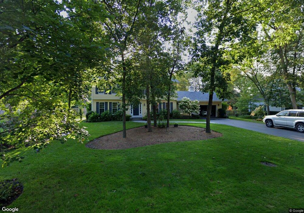
1180 Harlan Ct Lake Forest, IL 60045
Estimated Value: $888,000 - $945,194
4
Beds
3
Baths
2,787
Sq Ft
$325/Sq Ft
Est. Value
About This Home
This home is located at 1180 Harlan Ct, Lake Forest, IL 60045 and is currently estimated at $905,799, approximately $325 per square foot. 1180 Harlan Ct is a home located in Lake County with nearby schools including Cherokee Elementary School, Deer Path Middle School East, and Lake Forest High School.
Ownership History
Date
Name
Owned For
Owner Type
Purchase Details
Closed on
Oct 29, 2009
Sold by
Dayton Nick A and Dayton Marcia C
Bought by
Dayton Nick A and Dayton Marcia C
Current Estimated Value
Purchase Details
Closed on
Oct 7, 1996
Sold by
Burnette William W and Burnette Joann K
Bought by
Dayton Lewis A and Dayton Marcia C
Home Financials for this Owner
Home Financials are based on the most recent Mortgage that was taken out on this home.
Original Mortgage
$195,000
Interest Rate
8%
Create a Home Valuation Report for This Property
The Home Valuation Report is an in-depth analysis detailing your home's value as well as a comparison with similar homes in the area
Home Values in the Area
Average Home Value in this Area
Purchase History
| Date | Buyer | Sale Price | Title Company |
|---|---|---|---|
| Dayton Nick A | -- | None Available | |
| Dayton Lewis A | $490,000 | First American Title |
Source: Public Records
Mortgage History
| Date | Status | Borrower | Loan Amount |
|---|---|---|---|
| Closed | Dayton Lewis A | $195,000 |
Source: Public Records
Tax History Compared to Growth
Tax History
| Year | Tax Paid | Tax Assessment Tax Assessment Total Assessment is a certain percentage of the fair market value that is determined by local assessors to be the total taxable value of land and additions on the property. | Land | Improvement |
|---|---|---|---|---|
| 2024 | $14,114 | $250,730 | $97,125 | $153,605 |
| 2023 | $14,062 | $233,615 | $90,495 | $143,120 |
| 2022 | $14,062 | $240,249 | $85,246 | $155,003 |
| 2021 | $13,289 | $231,633 | $82,189 | $149,444 |
| 2020 | $12,944 | $232,120 | $82,362 | $149,758 |
| 2019 | $12,516 | $231,726 | $82,222 | $149,504 |
| 2018 | $12,876 | $250,280 | $87,149 | $163,131 |
| 2017 | $12,628 | $249,482 | $86,871 | $162,611 |
| 2016 | $12,238 | $240,048 | $83,586 | $156,462 |
| 2015 | $12,054 | $225,545 | $78,536 | $147,009 |
| 2014 | $9,981 | $190,003 | $79,097 | $110,906 |
| 2012 | $9,644 | $188,327 | $78,399 | $109,928 |
Source: Public Records
Map
Nearby Homes
- 687 W Old Elm Rd
- 1150 Highland Ave
- 124 W Old Elm Rd
- 1022 Estes Ave
- 1124 Fairview Ave
- 930 S Ridge Rd
- 1156 Mount Vernon Ave
- 555 W Everett Rd
- 710 Buena Rd
- 620 W Old Elm Rd
- 104 E Louis Ave
- 1627 S Ridge Rd
- 3464 Old Mill Rd
- 3390 Old Mill Rd
- 510 Buena Rd
- 499 W Old Mill Rd
- 1090 Evergreen Dr
- 1010 S Green Bay Rd
- 1020 Evergreen Dr
- 1330 Kurtis Ln
- 1190 Harlan Ct
- 1160 Harlan Ct
- 1175 Breckenridge Ave
- 1185 Breckenridge Ave
- 1155 Breckenridge Ave
- 1140 Harlan Ct
- 1167 Harlan Ct
- 1181 Harlan Ct
- 1141 Breckenridge Ave
- 1130 Harlan Ct
- 1137 Harlan Ct
- 1123 Breckenridge Ave
- 200 W Old Elm Rd
- 1230 Harlan Ln
- 1180 Breckenridge Ave
- 1190 Breckenridge Ave
- 1221 Breckenridge Ct
- 1160 Breckenridge Ave
- 249 Wilshire Rd
- 1158 S Ridge Rd