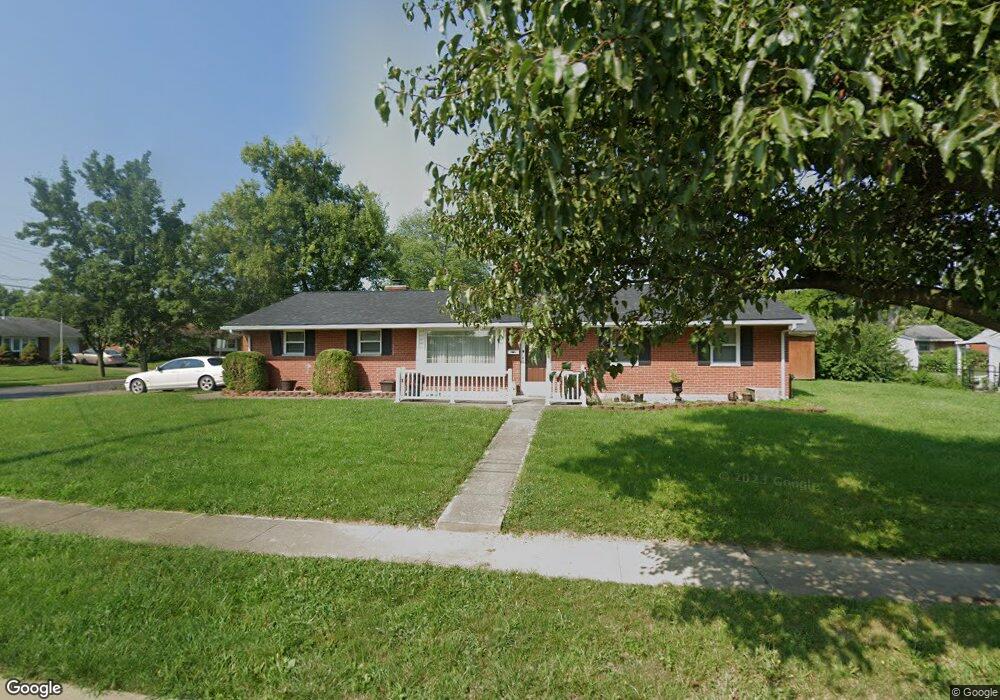
11807 Ramsdale Ct Cincinnati, OH 45246
Estimated Value: $225,641 - $239,000
3
Beds
2
Baths
1,362
Sq Ft
$171/Sq Ft
Est. Value
About This Home
This home is located at 11807 Ramsdale Ct, Cincinnati, OH 45246 and is currently estimated at $232,910, approximately $171 per square foot. 11807 Ramsdale Ct is a home located in Hamilton County with nearby schools including Springdale Elementary School, Princeton Community Middle School, and Princeton High School.
Ownership History
Date
Name
Owned For
Owner Type
Purchase Details
Closed on
Jul 10, 2019
Sold by
M & E Hall Homes Llc
Bought by
Blunt Richard
Current Estimated Value
Home Financials for this Owner
Home Financials are based on the most recent Mortgage that was taken out on this home.
Original Mortgage
$144,620
Outstanding Balance
$126,700
Interest Rate
3.82%
Mortgage Type
VA
Estimated Equity
$106,210
Purchase Details
Closed on
Apr 9, 2011
Sold by
Hall Edwin C and Hall Martha R
Bought by
M & E Hall Homes Llc
Purchase Details
Closed on
Aug 31, 2010
Sold by
Scholle Amy
Bought by
Hall Edwin C and Hall Martha R
Home Financials for this Owner
Home Financials are based on the most recent Mortgage that was taken out on this home.
Original Mortgage
$70,875
Interest Rate
4.19%
Mortgage Type
New Conventional
Purchase Details
Closed on
Aug 31, 2002
Sold by
Davis Edna L
Bought by
Davis Edna L and Scholle Amy
Create a Home Valuation Report for This Property
The Home Valuation Report is an in-depth analysis detailing your home's value as well as a comparison with similar homes in the area
Home Values in the Area
Average Home Value in this Area
Purchase History
| Date | Buyer | Sale Price | Title Company |
|---|---|---|---|
| Blunt Richard | $140,000 | American Homeland Title Agcy | |
| M & E Hall Homes Llc | -- | Attorney | |
| Hall Edwin C | $94,500 | Attorney | |
| Davis Edna L | -- | -- |
Source: Public Records
Mortgage History
| Date | Status | Borrower | Loan Amount |
|---|---|---|---|
| Open | Blunt Richard | $144,620 | |
| Previous Owner | Hall Edwin C | $70,875 |
Source: Public Records
Tax History Compared to Growth
Tax History
| Year | Tax Paid | Tax Assessment Tax Assessment Total Assessment is a certain percentage of the fair market value that is determined by local assessors to be the total taxable value of land and additions on the property. | Land | Improvement |
|---|---|---|---|---|
| 2024 | $2,405 | $55,822 | $13,790 | $42,032 |
| 2023 | $2,411 | $55,822 | $13,790 | $42,032 |
| 2022 | $2,602 | $49,001 | $9,993 | $39,008 |
| 2021 | $2,530 | $49,001 | $9,993 | $39,008 |
| 2020 | $2,562 | $49,001 | $9,993 | $39,008 |
| 2019 | $1,990 | $33,943 | $8,540 | $25,403 |
| 2018 | $1,877 | $33,943 | $8,540 | $25,403 |
| 2017 | $1,790 | $33,943 | $8,540 | $25,403 |
| 2016 | $1,672 | $31,091 | $8,883 | $22,208 |
| 2015 | $1,663 | $31,091 | $8,883 | $22,208 |
| 2014 | $1,665 | $31,091 | $8,883 | $22,208 |
| 2013 | $1,732 | $33,075 | $9,450 | $23,625 |
Source: Public Records
Map
Nearby Homes
- 11837 Mangrove Ln
- 11839 Mangrove Ln
- 11760 Van Camp Ln
- 107 Harter Ave
- 11907 Lawnview Ave
- 256 Centerbury Ct Unit 67
- 278 Centerbury Ct
- 275 Bennington Way
- 365 Northland Blvd
- 11566 Rose Ln
- 230 Edinburgh Ln Unit 47
- 228 Edinburgh Ln
- 415 Lisbon Ln
- 18 Oakwood Ct
- 403 Lisbon Ln Unit 131
- 43 Oakwood Ct
- 515 Grandin Ave
- 21 Aspen Ct
- 576 Grandin Ave
- 186 Garfield Ave
- 210 Ruskin Dr
- 11813 Ramsdale Ct
- 11806 Ramsdale Ct
- 11819 Ramsdale Ct
- 203 Ruskin Dr
- 11806 Lawnview Ave
- 211 Ruskin Dr
- 11810 Lawnview Ave
- 11814 Ramsdale Ct
- 219 Ruskin Dr
- 195 Ruskin Dr
- 182 Ruskin Dr
- 11816 Lawnview Ave
- 187 Ruskin Dr
- 227 Ruskin Dr
- 11825 Ramsdale Ct
- 11822 Ramsdale Ct
- 186 Balsam Ct
- 11820 Lawnview Ave
- 11774 Lawnview Ave