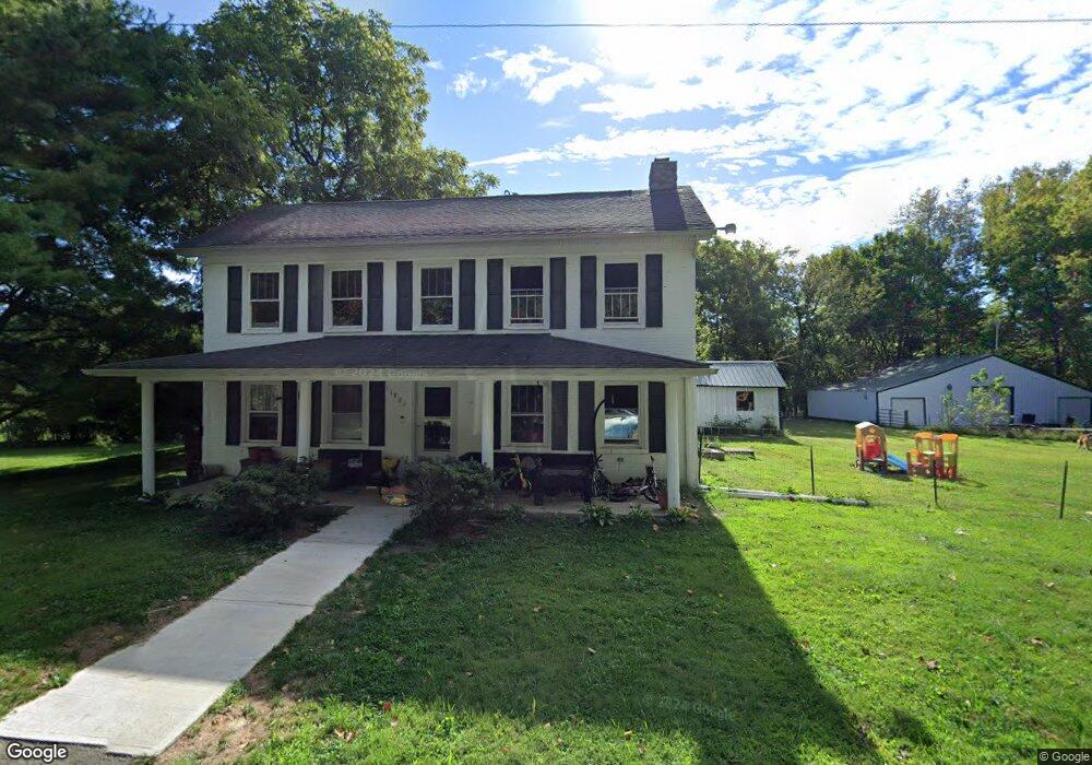
11808 Hauke Rd N Georgetown, OH 45121
Estimated Value: $204,000 - $340,000
3
Beds
1
Bath
2,592
Sq Ft
$101/Sq Ft
Est. Value
About This Home
This home is located at 11808 Hauke Rd N, Georgetown, OH 45121 and is currently estimated at $262,349, approximately $101 per square foot. 11808 Hauke Rd N is a home located in Brown County with nearby schools including Western Brown High School.
Ownership History
Date
Name
Owned For
Owner Type
Purchase Details
Closed on
Dec 2, 2022
Sold by
Roush Shawn and Roush Charles E
Bought by
Roush Charles E and Roush Shawn R
Current Estimated Value
Purchase Details
Closed on
Jan 27, 2009
Sold by
Wells Fargo Bank Na
Bought by
Roush Shawn and Roush Charles
Purchase Details
Closed on
Apr 3, 2008
Sold by
Leadmon Michael and Leadmon Michael S
Bought by
Wells Fargo Bank Na and Ownit Mortgage Loan Trust Mortgage Loan
Purchase Details
Closed on
Dec 20, 2005
Sold by
Cowdrey Lillian and Cowdrey Lillian Elnore
Bought by
Leadmon Michael
Home Financials for this Owner
Home Financials are based on the most recent Mortgage that was taken out on this home.
Original Mortgage
$76,000
Interest Rate
6.4%
Mortgage Type
Fannie Mae Freddie Mac
Create a Home Valuation Report for This Property
The Home Valuation Report is an in-depth analysis detailing your home's value as well as a comparison with similar homes in the area
Home Values in the Area
Average Home Value in this Area
Purchase History
| Date | Buyer | Sale Price | Title Company |
|---|---|---|---|
| Roush Charles E | $125 | -- | |
| Roush Shawn | $33,000 | Prism Title & Closing Servic | |
| Wells Fargo Bank Na | $43,334 | None Available | |
| Leadmon Michael | $96,000 | American Homeland Title Ags |
Source: Public Records
Mortgage History
| Date | Status | Borrower | Loan Amount |
|---|---|---|---|
| Previous Owner | Leadmon Michael | $76,000 |
Source: Public Records
Tax History Compared to Growth
Tax History
| Year | Tax Paid | Tax Assessment Tax Assessment Total Assessment is a certain percentage of the fair market value that is determined by local assessors to be the total taxable value of land and additions on the property. | Land | Improvement |
|---|---|---|---|---|
| 2024 | $1,401 | $51,350 | $7,140 | $44,210 |
| 2023 | $1,401 | $35,620 | $5,170 | $30,450 |
| 2022 | $1,028 | $35,620 | $5,170 | $30,450 |
| 2021 | $1,016 | $35,620 | $5,170 | $30,450 |
| 2020 | $911 | $30,980 | $4,500 | $26,480 |
| 2019 | $981 | $30,980 | $4,500 | $26,480 |
| 2018 | $972 | $30,980 | $4,500 | $26,480 |
| 2017 | $880 | $27,870 | $4,950 | $22,920 |
| 2016 | $880 | $27,870 | $4,950 | $22,920 |
| 2015 | $900 | $27,870 | $4,950 | $22,920 |
| 2014 | $900 | $27,420 | $4,500 | $22,920 |
| 2013 | $898 | $27,420 | $4,500 | $22,920 |
Source: Public Records
Map
Nearby Homes
- 7253 Main St
- 11864 Main St
- 11866 Main St
- 11868 Main St
- 12353 U S 68
- 4940 Goose Run Rd
- AC Stony Hollow Rd
- 12821 Beckelheimer Rd
- 10667 Hamer Rd
- 10702 Smoky Row Rd
- 10898 Parker Lane Rd
- 4656 Oakland Rd
- 11026 Stratton Rd
- 114 Tammera Ln
- 781 S High St
- 422 Liming Farm Rd
- 419 Liming Farm Rd
- 108 Brookshire Way
- 13523 Lake Grant Rd
- 4641 Wahlsburg East Rd
- 11819 Hauke Rd N
- 6292 Main St
- 7186 Main St
- 7064 Main St
- 6422 Main St
- 11863 New Hope-White Oak Station Rd
- 6463 Main St
- 7151 Main St
- 11871 Main St
- 11884 Walnut St
- 11874 Walnut St
- 1 Us Rt 68
- 11877 Main St
- 12463 St Rt 68
- 4042 Sterling Rd
- 6263 Main St
- .45Ac Main St
- 6664 Main St
- 11927 New Hope White Oak Station Rd
- 11923 New Hope-White Oak Station Rd