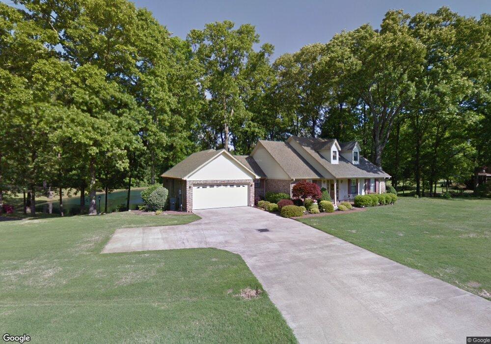
1185 Fronie Dr Nesbit, MS 38651
Estimated Value: $362,000 - $416,000
3
Beds
3
Baths
2,069
Sq Ft
$183/Sq Ft
Est. Value
About This Home
This home is located at 1185 Fronie Dr, Nesbit, MS 38651 and is currently estimated at $379,044, approximately $183 per square foot. 1185 Fronie Dr is a home located in DeSoto County with nearby schools including Oak Grove Central Elementary School, Hernando Hills Elementary, and Hernando Elementary School.
Ownership History
Date
Name
Owned For
Owner Type
Purchase Details
Closed on
May 18, 2021
Sold by
Barton Larry G and Barton Peggy
Bought by
Barton Larry G and Barton Peggy J
Current Estimated Value
Purchase Details
Closed on
Feb 6, 2009
Sold by
Brown Carl R and Brown Linda F
Bought by
Barton Larry G and Barton Peggy
Home Financials for this Owner
Home Financials are based on the most recent Mortgage that was taken out on this home.
Original Mortgage
$180,000
Outstanding Balance
$41,895
Interest Rate
5.08%
Mortgage Type
Credit Line Revolving
Estimated Equity
$337,149
Create a Home Valuation Report for This Property
The Home Valuation Report is an in-depth analysis detailing your home's value as well as a comparison with similar homes in the area
Home Values in the Area
Average Home Value in this Area
Purchase History
We collect this data history from publicly available records. To have your information removed, we recommend requesting removal directly through your county’s website.
| Date | Buyer | Sale Price | Title Company |
|---|---|---|---|
| Barton Larry G | -- | None Available | |
| Barton Larry G | -- | Fnf Title Svs Llc |
Source: Public Records
Mortgage History
We collect this data history from publicly available records. To have your information removed, we recommend requesting removal directly through your county’s website.
| Date | Status | Borrower | Loan Amount |
|---|---|---|---|
| Open | Barton Larry G | $180,000 |
Source: Public Records
Tax History
| Year | Tax Paid | Tax Assessment Tax Assessment Total Assessment is a certain percentage of the fair market value that is determined by local assessors to be the total taxable value of land and additions on the property. | Land | Improvement |
|---|---|---|---|---|
| 2025 | $809 | $14,446 | $2,500 | $11,946 |
| 2024 | $964 | $14,446 | $2,500 | $11,946 |
| 2023 | $964 | $14,446 | $0 | $0 |
| 2022 | $964 | $14,446 | $2,500 | $11,946 |
| 2021 | $964 | $14,446 | $2,500 | $11,946 |
| 2020 | $964 | $14,446 | $2,500 | $11,946 |
| 2019 | $964 | $14,446 | $2,500 | $11,946 |
| 2017 | $895 | $25,338 | $13,919 | $11,419 |
| 2016 | $858 | $13,919 | $2,500 | $11,419 |
| 2015 | $1,860 | $25,338 | $13,919 | $11,419 |
| 2014 | $837 | $13,919 | $0 | $0 |
| 2013 | $837 | $13,919 | $0 | $0 |
Source: Public Records
Map
Nearby Homes
- 0 Jackson Rd
- 0 Highway 51 Unit 2319030
- 1461 Dogwood Hollow Dr
- 970 Coahoma Ct
- 433 Sunflower St
- 940 Coahoma Ct
- 902 Coahoma Ct
- 878 Coahoma Ct
- 854 Coahoma Ct
- 502 Bolivar Dr
- 514 Bolivar Dr
- 842 Coahoma Ct
- 836 Coahoma Ct
- 538 Bolivar Dr
- 0 Old Highway 51 N Unit 4141927
- 767 Coahoma Ct
- 838 Quitman Ct W
- 828 Quitman Ct W
- 779 Quitman Ct W
- 773 Quitman Ct W
Your Personal Tour Guide
Ask me questions while you tour the home.