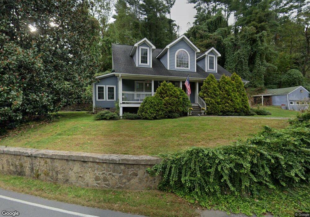
1185 Hayes Run Rd Marshall, NC 28753
Estimated Value: $532,000 - $822,003
Studio
1
Bath
2,788
Sq Ft
$243/Sq Ft
Est. Value
About This Home
This home is located at 1185 Hayes Run Rd, Marshall, NC 28753 and is currently estimated at $677,001, approximately $242 per square foot. 1185 Hayes Run Rd is a home located in Madison County with nearby schools including Madison Middle School.
Ownership History
Date
Name
Owned For
Owner Type
Purchase Details
Closed on
Aug 31, 2005
Sold by
Martin Thomas Edsel and Gregory Susan
Bought by
Price William and Price Frances J
Current Estimated Value
Home Financials for this Owner
Home Financials are based on the most recent Mortgage that was taken out on this home.
Original Mortgage
$197,303
Outstanding Balance
$105,026
Interest Rate
5.77%
Mortgage Type
VA
Estimated Equity
$571,975
Create a Home Valuation Report for This Property
The Home Valuation Report is an in-depth analysis detailing your home's value as well as a comparison with similar homes in the area
Home Values in the Area
Average Home Value in this Area
Purchase History
| Date | Buyer | Sale Price | Title Company |
|---|---|---|---|
| Price William | $191,000 | None Available |
Source: Public Records
Mortgage History
| Date | Status | Borrower | Loan Amount |
|---|---|---|---|
| Open | Price William | $197,303 |
Source: Public Records
Tax History
| Year | Tax Paid | Tax Assessment Tax Assessment Total Assessment is a certain percentage of the fair market value that is determined by local assessors to be the total taxable value of land and additions on the property. | Land | Improvement |
|---|---|---|---|---|
| 2024 | $3,009 | $643,022 | $125,404 | $517,618 |
| 2023 | $2,205 | $349,169 | $84,985 | $264,184 |
| 2022 | $2,205 | $349,169 | $84,985 | $264,184 |
| 2021 | $2,205 | $349,169 | $84,985 | $264,184 |
| 2020 | $1,926 | $349,169 | $84,985 | $264,184 |
| 2019 | $1,670 | $274,516 | $67,994 | $206,522 |
| 2018 | $1,647 | $0 | $0 | $0 |
| 2017 | $1,647 | $0 | $0 | $0 |
| 2016 | $1,647 | $0 | $0 | $0 |
| 2015 | -- | $0 | $0 | $0 |
| 2014 | -- | $274,516 | $67,994 | $206,522 |
| 2013 | -- | $188,419 | $67,994 | $120,425 |
Source: Public Records
Map
Nearby Homes
- 461 Tweed Rd
- Lot 2 Lunsford Ln
- 0 Anderson Cove Rd
- 140 Rector Corner Cir
- 1126 Rector Corner Rd
- 456 Rector Corner Rd
- 55 Webb Dr
- 55 & 119 Webb Dr
- 99999 Baileys Branch Rd
- 1231 Baileys Branch Rd Unit 3
- 2200 Walnut Creek Rd
- 849 S Ammons Branch Rd
- 131 Ivy Bluffs Rd Unit 3
- 200 Dry Branch Rd
- 1623 Ammons Branch Rd
- 1974 Ammons Branch Rd
- 2776 Bend of Ivy Rd
- 10 Scarlett Ridge Dr
- 2301 Silver Mill Rd
- 235 Petersburg View Dr
- 1202 Hayes Run Rd
- 34 Buckeye Ridge
- 1251 Hayes Run Rd
- 1210 Hayes Run Rd
- 0000 Hwy 213
- 000 Hwy 213
- 00 Hwy 213
- Lot #4 Crossing Pkwy Unit 4
- 4386 Us 25/70 Hwy
- 4223 Us 25/70 Hwy
- 181 Fore Rd
- 1406 Nc 213 Hwy
- 1406 Nc 213 Hwy
- 4226 Us 25/70 Hwy
- 1102 Hayes Run Rd
- 1102 Hayes Run Rd
- 160 Fore Rd
- 130 Ogle Dr
- 99 Long Branch Rd
- 99 Long Branch Rd Unit Lot 5
Your Personal Tour Guide
Ask me questions while you tour the home.