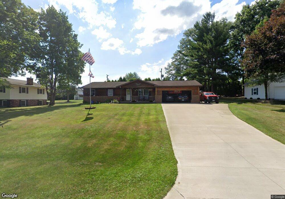
1185 Summerset Dr Wooster, OH 44691
Estimated Value: $245,050 - $290,000
3
Beds
2
Baths
1,288
Sq Ft
$207/Sq Ft
Est. Value
About This Home
This home is located at 1185 Summerset Dr, Wooster, OH 44691 and is currently estimated at $266,013, approximately $206 per square foot. 1185 Summerset Dr is a home located in Wayne County with nearby schools including Triway High School, St Mary Of Immaculate Conception School, and Montessori School of Wooster.
Ownership History
Date
Name
Owned For
Owner Type
Purchase Details
Closed on
Jul 31, 2009
Sold by
Hamilton Deanna Ann
Bought by
Hamilton Scott Allen
Current Estimated Value
Purchase Details
Closed on
Oct 19, 1990
Sold by
Pollmeier Freda
Bought by
Hamilton Scott Allen and Hamilton De
Purchase Details
Closed on
Apr 29, 1988
Sold by
Raber Mark O and Raber Linda M
Bought by
Pollmeier Freda
Purchase Details
Closed on
Jun 24, 1987
Bought by
Raber Mark O and Raber Linda M
Create a Home Valuation Report for This Property
The Home Valuation Report is an in-depth analysis detailing your home's value as well as a comparison with similar homes in the area
Home Values in the Area
Average Home Value in this Area
Purchase History
| Date | Buyer | Sale Price | Title Company |
|---|---|---|---|
| Hamilton Scott Allen | -- | Attorney | |
| Hamilton Scott Allen | $80,000 | -- | |
| Pollmeier Freda | $67,900 | -- | |
| Raber Mark O | $14,000 | -- |
Source: Public Records
Tax History
| Year | Tax Paid | Tax Assessment Tax Assessment Total Assessment is a certain percentage of the fair market value that is determined by local assessors to be the total taxable value of land and additions on the property. | Land | Improvement |
|---|---|---|---|---|
| 2024 | $2,639 | $72,640 | $13,760 | $58,880 |
| 2023 | $2,657 | $72,640 | $13,760 | $58,880 |
| 2022 | $2,280 | $56,320 | $10,670 | $45,650 |
| 2021 | $2,130 | $56,320 | $10,670 | $45,650 |
| 2020 | $2,155 | $56,320 | $10,670 | $45,650 |
| 2019 | $1,748 | $44,030 | $9,990 | $34,040 |
| 2018 | $1,779 | $44,030 | $9,990 | $34,040 |
| 2017 | $1,772 | $44,030 | $9,990 | $34,040 |
| 2016 | $1,723 | $42,330 | $9,600 | $32,730 |
| 2015 | $1,683 | $42,330 | $9,600 | $32,730 |
| 2014 | $1,685 | $42,330 | $9,600 | $32,730 |
| 2013 | $1,753 | $42,270 | $9,630 | $32,640 |
Source: Public Records
Map
Nearby Homes
- 2717 Timothy Place
- 5 E Melrose Unit 5
- 140 Ohio St
- 758 Western Dr
- 2820 Indian Run
- 227 N Walnut St
- 230 Clark Ave
- 801 & 803 Colony Ct
- 423 N Market St
- 223 E Larwill St
- 534 N Buckeye St
- 606 E Henry St
- 134 E Bowman St Unit 1/2
- 1047 Ashwood Dr
- 331 Derr Ave
- 851 Park Blvd
- 419 Nold Ave
- 2535 Millersburg Rd
- 814 N Bever St
- 1704 Carlin Trail
- 1175 Summerset Dr
- 1195 Summerset Dr
- 1190 Summerset Dr
- 1167 Summerset Dr
- 1261 Sunnyview Ln
- 1296 Blachleyville Rd
- 1280 Blachleyville Rd
- 1257 Blachleyville Rd
- 1270 Blachleyville Rd
- 1157 Summerset Dr
- 1314 Blachleyville Rd
- 1253 Sunnyview Ln
- 1320 Blachleyville Rd
- 1249 Blachleyville Rd
- 1256 Sunnyview Ln
- 1145 Summerset Dr
- 1250 Blachleyville Rd
- 1350 Blachleyville Rd
- 1287 Center Dr
- 1245 Sunnyview Ln
Your Personal Tour Guide
Ask me questions while you tour the home.