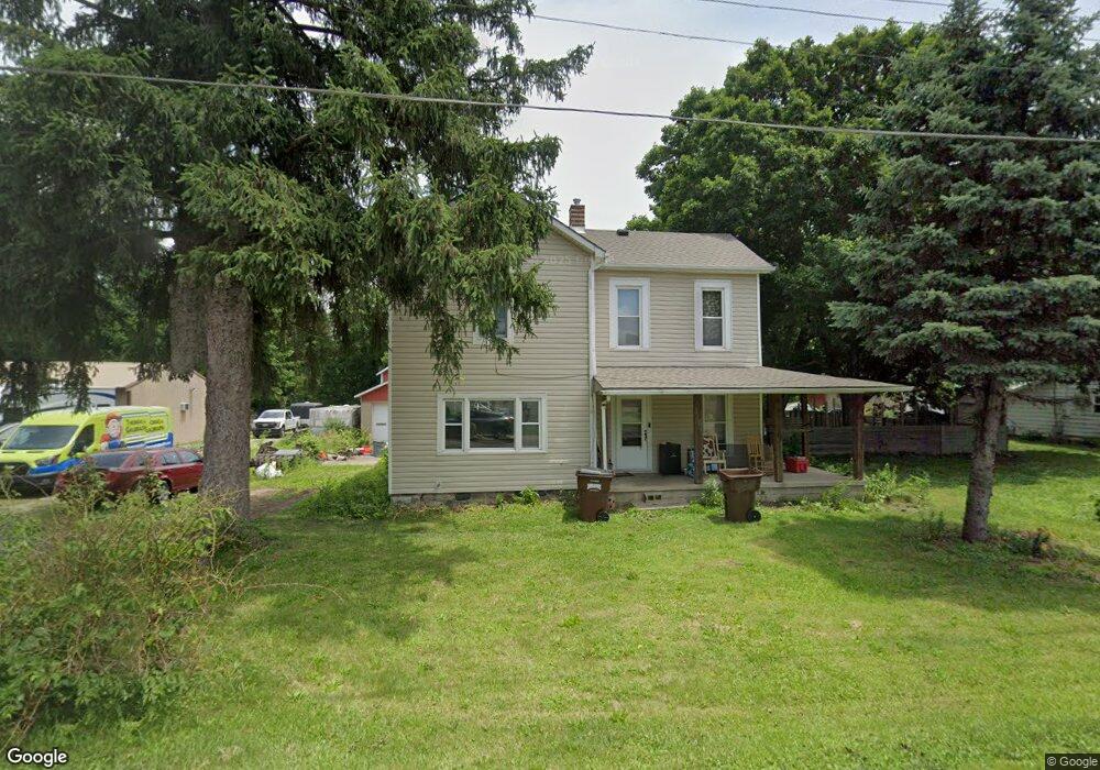
1186 State Route 503 S West Alexandria, OH 45381
Estimated Value: $265,000 - $324,000
4
Beds
2
Baths
1,536
Sq Ft
$189/Sq Ft
Est. Value
About This Home
This home is located at 1186 State Route 503 S, West Alexandria, OH 45381 and is currently estimated at $290,855, approximately $189 per square foot. 1186 State Route 503 S is a home located in Preble County with nearby schools including Twin Valley South Elementary School, Twin Valley South Middle School, and Twin Valley South High School.
Ownership History
Date
Name
Owned For
Owner Type
Purchase Details
Closed on
Apr 20, 2018
Sold by
Hittle Jill E
Bought by
Burkett Donald E and Burkett Sharon L
Current Estimated Value
Purchase Details
Closed on
Sep 22, 2005
Sold by
Dunker Annaliese M
Bought by
Haines Martha Louise and Dunker Henry William
Create a Home Valuation Report for This Property
The Home Valuation Report is an in-depth analysis detailing your home's value as well as a comparison with similar homes in the area
Home Values in the Area
Average Home Value in this Area
Purchase History
| Date | Buyer | Sale Price | Title Company |
|---|---|---|---|
| Burkett Donald E | $14,000 | None Available | |
| Hittle Jill E | -- | None Available | |
| Haines Martha Louise | -- | None Available |
Source: Public Records
Tax History Compared to Growth
Tax History
| Year | Tax Paid | Tax Assessment Tax Assessment Total Assessment is a certain percentage of the fair market value that is determined by local assessors to be the total taxable value of land and additions on the property. | Land | Improvement |
|---|---|---|---|---|
| 2024 | $2,517 | $82,120 | $21,040 | $61,080 |
| 2023 | $2,517 | $82,120 | $21,040 | $61,080 |
| 2022 | $2,057 | $64,580 | $19,740 | $44,840 |
| 2021 | $2,230 | $64,580 | $19,740 | $44,840 |
| 2020 | $2,135 | $64,580 | $19,740 | $44,840 |
| 2019 | $2,141 | $41,760 | $16,450 | $25,310 |
| 2018 | $1,442 | $39,910 | $14,600 | $25,310 |
| 2017 | $3,346 | $205,460 | $180,150 | $25,310 |
| 2016 | $4,307 | $175,460 | $151,730 | $23,730 |
| 2014 | $4,266 | $175,490 | $151,760 | $23,730 |
| 2013 | $2,471 | $139,055 | $115,325 | $23,730 |
Source: Public Records
Map
Nearby Homes
- 4801 Fisher Twin Rd
- 1389 Leon Dr
- 3292 Twin Creek Rd
- 60 Hope Ave
- 37 Smith St
- 1020 Howard Ct
- 10 Western Dr
- 3659 Winston Ln
- 0 U S 35
- 52 E 2nd St
- 36 E 3rd St
- 212 E 3rd St
- 6762 U S 35
- 0 State Rt 35 Unit 935251
- 60 Enterprise Rd
- 1148 State Route 503 N
- 15600 Dechant Rd
- 1111 Bull Rd
- 99 Katherine Dr
- 205 Ada Doty St
- 6130 Factory Rd
- 1987 Mill Rd
- 6318 Factory Rd
- 6318 Factory Rd
- 6151 Factory Rd
- 6203 Factory Rd
- 6131 Factory Rd
- 6028 Factory Rd
- 6315 Factory Rd
- 2108 Mill Rd
- 2108 Mill Rd
- 1716 N Factory Rd
- 1714 N Factory Rd
- 6335 Factory Rd
- 6051 Factory Rd
- 6031 Factory Rd
- 1647 State Route 503 S
- 1599 State Route 503 S
- 1599 S 503 State
- 2144 State Route 503 S