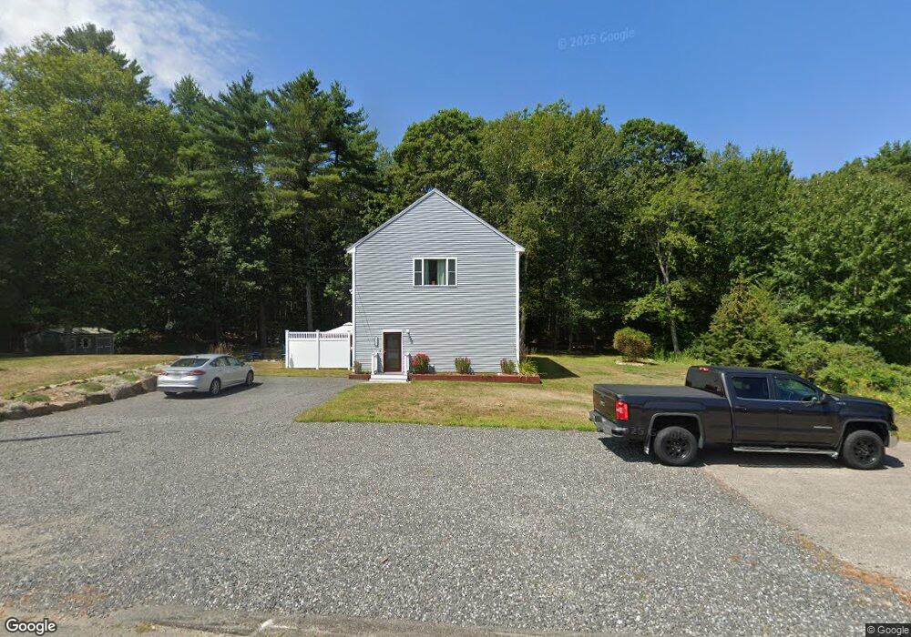
1186 Us Route 1 York, ME 03909
Ogunquit NeighborhoodEstimated Value: $412,000 - $606,000
--
Bed
--
Bath
--
Sq Ft
0.56
Acres
About This Home
This home is located at 1186 Us Route 1, York, ME 03909 and is currently estimated at $538,106. 1186 Us Route 1 is a home located in York County with nearby schools including Coastal Ridge Elementary School, Village Elementary School, and York Middle School.
Ownership History
Date
Name
Owned For
Owner Type
Purchase Details
Closed on
Jul 1, 2013
Sold by
Turgeon Joseph H
Bought by
Turgeon Joseph H and Gilbert Channie L
Current Estimated Value
Purchase Details
Closed on
Jun 27, 2011
Sold by
Brewster 3Rd James E and Brewster Gloria H
Bought by
Brewster April L
Purchase Details
Closed on
Jan 31, 2011
Sold by
Turgeon Joseph H
Bought by
Brewster 3Rd James E and Brewster April L
Purchase Details
Closed on
Jan 16, 2009
Sold by
Brewster Gloria H and Brewster 3Rd James E
Bought by
Brewster April L
Create a Home Valuation Report for This Property
The Home Valuation Report is an in-depth analysis detailing your home's value as well as a comparison with similar homes in the area
Home Values in the Area
Average Home Value in this Area
Purchase History
| Date | Buyer | Sale Price | Title Company |
|---|---|---|---|
| Turgeon Joseph H | -- | -- | |
| Turgeon Joseph H | -- | -- | |
| Brewster April L | -- | -- | |
| Brewster April L | -- | -- | |
| Brewster 3Rd James E | -- | -- | |
| Turgeon Joseph H | -- | -- | |
| Brewster April L | -- | -- | |
| Brewster April L | -- | -- |
Source: Public Records
Mortgage History
| Date | Status | Borrower | Loan Amount |
|---|---|---|---|
| Previous Owner | Brewster April L | $277,000 |
Source: Public Records
Tax History Compared to Growth
Tax History
| Year | Tax Paid | Tax Assessment Tax Assessment Total Assessment is a certain percentage of the fair market value that is determined by local assessors to be the total taxable value of land and additions on the property. | Land | Improvement |
|---|---|---|---|---|
| 2024 | $3,772 | $449,000 | $178,200 | $270,800 |
| 2023 | $3,503 | $414,500 | $143,700 | $270,800 |
| 2022 | $3,373 | $394,500 | $143,700 | $250,800 |
| 2021 | $3,188 | $320,400 | $111,800 | $208,600 |
| 2020 | $3,094 | $278,700 | $111,800 | $166,900 |
| 2019 | $2,861 | $256,600 | $92,600 | $164,000 |
| 2018 | $1,474 | $256,600 | $92,600 | $164,000 |
| 2017 | $2,813 | $256,900 | $92,600 | $164,300 |
| 2016 | $2,793 | $250,500 | $86,200 | $164,300 |
| 2015 | $2,618 | $238,000 | $83,000 | $155,000 |
| 2014 | $2,547 | $238,000 | $83,000 | $155,000 |
| 2013 | $2,461 | $236,000 | $79,900 | $156,100 |
Source: Public Records
Map
Nearby Homes
- 55 Simpson Hill Rd
- 1 Cassidy Way
- 7 Cappy's Ln
- 147 River Rd
- 4 Hamlin Place
- 39 Main St
- 1376 Us Route 1
- Lot # B Newport Ave
- 16 Passaic Rd
- 2 Beach St Unit 16
- 1 Ocean Ave Unit 306/308 Fraction 5
- 1 Ocean Ave Unit 306/308 Fraction 4
- 1 Ocean Ave Unit 406/408 Fraction 4
- 1 Ocean Ave Unit 210/212 Fraction 3
- 1 Ocean Ave Unit 402/404 Fraction 1
- 35 Gunnison Rd
- 384 Ridge Rd
- 4 Surfore Dr
- 8 Surfore Rd
- 10 Pine Mountain Rd
- 1186 Us Route 1
- 1186 U S 1
- 1183 Us Route 1
- 1183 U S 1
- 1191 Us Route 1
- 1 Branley Ln
- 1187 Us Route 1
- 1195 Us Route 1
- 1176 Us Route 1
- 1175 Us Route 1
- 1175 Us Route 1
- 1175 Us Route One
- 1200 U S 1
- 4 Martin Ln
- 1171 Us Route 1
- 1 Steam Mill Road(us Route 1 & C Rd
- 1210 Us Route 1
- 1 Steam Mill Rd
- 1 Steam Mill Rd Unit 1
- 1 Steam Mill Rd Unit 2