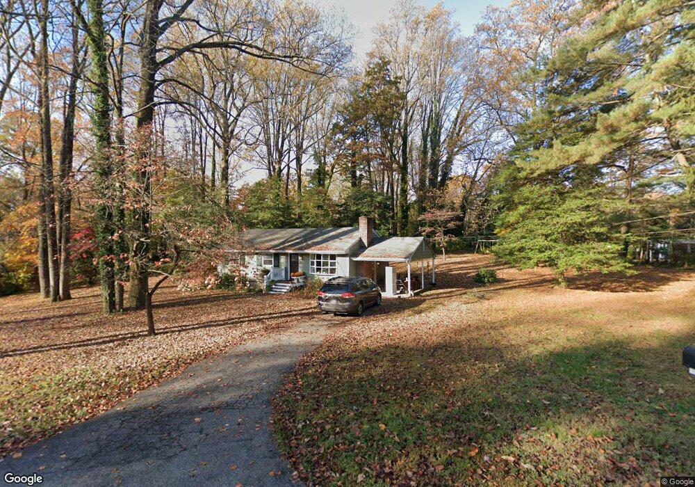
1186 Wright Ave Arnold, MD 21012
Estimated Value: $511,000 - $630,000
4
Beds
2
Baths
1,920
Sq Ft
$295/Sq Ft
Est. Value
About This Home
This home is located at 1186 Wright Ave, Arnold, MD 21012 and is currently estimated at $566,578, approximately $295 per square foot. 1186 Wright Ave is a home located in Anne Arundel County with nearby schools including Arnold Elementary School, Severn River Middle School, and Broadneck High School.
Ownership History
Date
Name
Owned For
Owner Type
Purchase Details
Closed on
Jul 28, 1994
Sold by
Toomey Anna G
Bought by
Kawecli Michael P
Current Estimated Value
Home Financials for this Owner
Home Financials are based on the most recent Mortgage that was taken out on this home.
Original Mortgage
$151,432
Interest Rate
8.25%
Create a Home Valuation Report for This Property
The Home Valuation Report is an in-depth analysis detailing your home's value as well as a comparison with similar homes in the area
Home Values in the Area
Average Home Value in this Area
Purchase History
| Date | Buyer | Sale Price | Title Company |
|---|---|---|---|
| Kawecli Michael P | $153,600 | -- |
Source: Public Records
Mortgage History
| Date | Status | Borrower | Loan Amount |
|---|---|---|---|
| Closed | Kawecli Michael P | $151,432 |
Source: Public Records
Tax History
| Year | Tax Paid | Tax Assessment Tax Assessment Total Assessment is a certain percentage of the fair market value that is determined by local assessors to be the total taxable value of land and additions on the property. | Land | Improvement |
|---|---|---|---|---|
| 2025 | $4,900 | $425,000 | -- | -- |
| 2024 | $4,900 | $401,600 | $296,500 | $105,100 |
| 2023 | $4,788 | $395,100 | $0 | $0 |
| 2022 | $4,491 | $388,600 | $0 | $0 |
| 2020 | $4,180 | $362,633 | $0 | $0 |
| 2019 | $3,980 | $343,167 | $0 | $0 |
| 2018 | $3,282 | $323,700 | $209,500 | $114,200 |
| 2017 | $3,564 | $312,200 | $0 | $0 |
| 2016 | -- | $300,700 | $0 | $0 |
| 2015 | -- | $289,200 | $0 | $0 |
| 2014 | -- | $289,200 | $0 | $0 |
Source: Public Records
Map
Nearby Homes
- 1232 Taylor Ave
- 1277 Ritchie Hwy Unit 195
- 1199 Asquithpines Place
- 394 Kings College Dr
- 1294 Circle Dr
- 1350 Ritchie Hwy
- 1078 Brightleaf Ct
- 1394 Baltimore Annapolis Blvd
- 303 Ternwing Dr
- 208 Admirals Ct
- 1396 Baltimore Annapolis Blvd
- 93 Jones Station Rd
- 136 Collington Ct
- 276 Overleaf Dr
- 785 Macsherry Dr
- 1420 Gilbert Rd
- 1420 Mariner Dr
- 1419 Mariner Dr
- 1230 Balfour Dr
- 371 Freshfield Ln
- 1180 Wright Ave
- 1193 Bunker Ave
- 95 Brooks Rd
- 1185 Wright Ave
- 1189 Bunker Ave
- 1174 Wright Ave
- 1204 Timber Turn
- 1179 Wright Ave
- 1177 Bunker Ave
- 77 Brooks Rd
- 1190 Bunker Ave
- 1188 Bunker Ave
- 1210 Timber Turn
- 1186 Bunker Ave
- 95 Moore Rd
- 1196 Bunker Ave
- 93 Moore Rd
- 1173 Wright Ave
- 1170 Rupert Cir
- 1205 Finneans Run
Your Personal Tour Guide
Ask me questions while you tour the home.